close
Trail Conditions
- Unknown
- Snow Groomed
- Snow Packed
- Snow Covered
- Snow Cover Inadequate
- Freeze/thaw Cycle
- Icy
- Prevalent Mud
- Wet
- Variable
- Ideal
- Dry
- Very Dry
Trail Flow (Ridden Direction)
Trailforks scans users ridelogs to determine the most popular direction each trail is ridden. A good flowing trail network will have most trails flowing in a single direction according to their intension.
The colour categories are based on what percentage of riders are riding a trail in its intended direction.
The colour categories are based on what percentage of riders are riding a trail in its intended direction.
- > 96%
- > 90%
- > 80%
- > 70%
- > 50%
- < 50%
- bi-directional trail
- no data
Trail Last Ridden
Trailforks scans ridelogs to determine the last time a trail was ridden.
- < 2 days
- < 1 week
- < 2 weeks
- < 1 month
- < 6 months
- > 6 months
Trail Ridden Direction
The intended direction a trail should be ridden.
- Downhill Only
- Downhill Primary
- Both Directions
- Uphill Primary
- Uphill Only
- One Direction
Contribute Details
Colors indicate trail is missing specified detail.
- Description
- Photos
- Description & Photos
- Videos
Trail Popularity ?
Trailforks scans ridelogs to determine which trails are ridden the most in the last 9 months.
Trails are compared with nearby trails in the same city region with a possible 25 colour shades.
Think of this as a heatmap, more rides = more kinetic energy = warmer colors.
- most popular
- popular
- less popular
- not popular
ATV/ORV/OHV Filter
Max Vehicle Width
inches
Radar Time
x
Activity Recordings
Trailforks users anonymized public ridelogs from the past 6 months.
- mountain biking recent
- mountain biking (>6 month)
- hiking (1 year)
- moto (1 year)
Activity Recordings
Trailforks users anonymized public skilogs from the past 12 months.
- Downhill Ski
- Backcountry Ski
- Nordic Ski
Jump Magnitude Heatmap
Heatmap of where riders jump on trails. Zoom in to see individual jumps, click circles to view jump details.
Trails Deemphasized
Trails are shown in grey.
Only show trails with NO bikes.
Save the current map location and zoom level as your default home location whenever this page is loaded.
SaveWhile San Diego is considered by many riders to be more mellow than other trails in California, it certainly has something for everyone. Most riding areas in San Diego are a combination of singletrack and fireroads to provide connectivity. Head to Penasqutios Canyon and you'll find a variety of trails that are good for beginner and intermediate riders. Head to Black Mountain if you like the more rocky, technical trails with healthy dose of elevation, and go to Lake Hodges (San Dieguito River Park) if you're into a mix of the aforementioned riding areas. A little over an hour from downtown San Diego will get you to the Cleveland National Forest, featuring Noble Canyon, one of SoCal's best downhill trails. Cuyamaca State Park also offers some awesome singletrack and vistas as well
Activities Click to view
- Mountain Bike
433 trails
- E-Bike
225 trails
- Hike
436 trails
- Trail Running
434 trails
- Horse
15 trails
Region Details
- 60
- 27
- 155
- 156
- 25
- 2
- 2
Region Status
Open as of May 15, 2020Stats
- Avg Trail Rating
- Trails (view details)
- 446
- Trails Mountain Bike
- 433
- Trails E-Bike
- 225
- Trails Hike
- 436
- Trails Trail Running
- 434
- Trails Horse
- 15
- Total Distance
- 306 miles
- Total Descent
- 37,716 ft
- Total Vertical
- 1,576 ft
- Highest Trailhead
- 1,582 ft
- Reports
- 5,016
- Photos
- 1,306
- Ridden Counter
- 104,790
Sub Regions
-
Balboa Park
- 4
- 17
- 30
- 4
-
Black Mountain
- 3
- 32
- 22
- 3
-
City Heights
- 8
- 1
- 1
-
Cowles Mountain
- 1
- 3
-
Downtown
-
Fanita / Melbrooks Trail System
- 1
-
Los Peñasquitos Canyon
- 13
- 52
- 46
- 5
- 1
-
Mission Trails Regional Park
- 20
- 17
- 5
-
Rose Canyon
- 4
- 1
- 1
-
Sycamore Canyon/Goodan Ranch
- 5
- 9
-
Tri-Canyons
- 5
- 11
- 11
- 2
Popular San Diego Mountain Biking Trails
San Diego Mountain Bike Routes
| title | rating | distance |
|---|---|---|
| The East Ender | 21 miles | |
| Flow Equation | 8 miles | |
| Los Penasquitos Canyon Loop aMTB-2 | 12 miles | |
| Tour de Black Mountain | 15 miles | |
| Big PQ Loop w/Ocean Air and Shits | 18 miles | |
| Call Me Black Mountain | 9 miles | |
| Omission Trails | 8 miles | |
| MBB Long Black Mountain RB Loop | 14 miles | |
| PQ Quick Run | 8 miles | |
| Southern Pacific Surprise | 11 miles |
Photos of San Diego Mountain Bike
trail: Gonzales Access Trail
1 |
Jul 2, 2022 @ 6:51am
Jul 2, 2022
trail: Intuit
71 |
Aug 9, 2020 @ 3:54pm
Aug 9, 2020
trail: Intuit
70 |
Aug 9, 2020 @ 3:54pm
Aug 9, 2020
trail: Nighthawk Connector
380 |
Mar 14, 2020 @ 7:33pm
Mar 14, 2020
trail: Black Widow
705 |
Nov 23, 2019 @ 12:11pm
Nov 23, 2019
trail: BD
459 | | 3 comments
Jan 2, 2014 @ 3:13pm
Jan 2, 2014
trail: BD
200 |
Dec 9, 2013 @ 8:57pm
Dec 9, 2013Videos of San Diego Mountain Bike
trail: Gonzales Access Trail
18 |
Mar 21, 2022

trail: September Street Trail
54 |
Jan 7, 2022

75 |
Jun 2, 2021
trail: Stowe Trail
61 |
Apr 5, 2021

trail: Singletrack Willy
210 |
Apr 1, 2021

trail: E-Ticket (Upper)
33 |
Jan 16, 2021
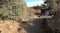
trail: Cobbles
122 |
Oct 31, 2020
trail: PQ Creek Park Access
0:36 |
118 |
Sep 23, 2020
Current Trail Warnings
| status | trail | date | condition | user | info |
|---|---|---|---|---|---|
| Tunnel 4 | Jun 29, 2022 @ 12:30pm Jun 29, 2022 | Ideal | bike4us | E-Bike Please watch for any horse traffic and... | |
| Wagon Wheel Crossing | Jun 19, 2022 @ 5:11pm Jun 19, 2022 | Dry | Pedronorapido |
Recent Trail Reports
| status | trail | date | condition | info | user |
|---|---|---|---|---|---|
| Ahwee Trail | Jul 4, 2022 @ 6:59pm 1 day | Ideal | d1d | ||
| Stowe Trail | Jul 4, 2022 @ 8:40am 2 days | Ideal | cedenburn | ||
| Grasslands Crossing | Jul 2, 2022 @ 6:20am Jul 2, 2022 | Very Dry | SteelySteve | ||
| East Tunnel Escape | Jul 1, 2022 @ 8:56am Jul 1, 2022 | Dry | brianpetry TRAILFORKS | ||
| Black Mountian Summit Road | Jun 22, 2022 @ 6:22am Jun 22, 2022 | Dry | Thebler | ||
| Black Widow | Jun 22, 2022 @ 6:22am Jun 22, 2022 | Dry | Thebler | ||
| Wheelie Drop | Jun 22, 2022 @ 6:22am Jun 22, 2022 | Dry | Thebler | ||
| Martha's Grove Connector | Jun 20, 2022 @ 9:57am Jun 20, 2022 | Dry | cedenburn | ||
| Martha's Doubletrack | Jun 20, 2022 @ 9:57am Jun 20, 2022 | Dry | cedenburn | ||
| West Boundary Trail | Jun 20, 2022 @ 9:57am Jun 20, 2022 | Dry | cedenburn |
Activity Feed
| username | action | type | title | date | |
|---|---|---|---|---|---|
 | MTBDan23 | wishlist | region | Los Peñasquitos Canyon | Jul 5, 2022 @ 4:16pm 10 hours |
| MTBDan23 | ridden | trail | Shepherd Ridge Trail | Jul 5, 2022 @ 3:56pm 10 hours |
| d1d | checkin | trail | Ahwee Trail and 2 more | Jul 4, 2022 @ 6:59pm 1 day |
| d1d | add | report | Ahwee Trail | Jul 4, 2022 @ 6:59pm 1 day |
| d1d | ridden | trail | Ahwee Trail and 2 more | Jul 4, 2022 @ 6:55pm 1 day |
Recent Comments
| username | type | title | comment | date | |
|---|---|---|---|---|---|
| trail | Fun but very hard as a climb. Not sure if... | Jul 4, 2022 @ 7:08am 2 days | ||
 | report | If you have any info, please contact SDMBA... | Jul 1, 2022 @ 12:25pm Jul 1, 2022 | ||
| trail | This is called September Street Trail. | Jun 29, 2022 @ 9:01pm Jun 29, 2022 | ||
| trail | Keller Canyon Trail | Jun 29, 2022 @ 8:59pm Jun 29, 2022 | ||
| trail | MTB Trail review has an older video '18 going... | Jun 28, 2022 @ 9:03pm Jun 28, 2022 |
Local Badges
-

Completionist2 awarded -

Top 10 Trails4 awarded -

Top 10 Trails2 awarded -
10 Green Trails943 awarded -

Completionist3 awarded -

Big Ride 30k13,371 awarded
Bike & Skill Parks
| name | type | city | rating |
|---|---|---|---|
| Carmel Valley Pumptrack | skill park | San Diego | |
| Deerfield BMX | skill park | San Diego | |
| Sweetwater Bike Park | skill park | San Diego |
Activity Type Stats
| activitytype | trails | distance | descent | descent distance | total vertical | rating | global rank | state rank | photos | reports | routes | ridelogs |
|---|---|---|---|---|---|---|---|---|---|---|---|---|
| Mountain Bike | 433 | 292 miles | 36,759 ft | 122 miles | 1,555 ft | #34 | #14 | 1,289 | 5,010 | 60 | 95,928 | |
| E-Bike | 225 | 178 miles | 19,879 ft | 74 miles | 1,549 ft | #18 | #6 | 14 | 4,480 | 23 | 2,799 | |
| Hike | 436 | 301 miles | 36,742 ft | 123 miles | 1,578 ft | #25 | #13 | 3 | 4,967 | 9 | 3,289 | |
| Trail Running | 434 | 300 miles | 36,460 ft | 122 miles | 1,578 ft | #25 | #13 | 4,966 | 8 | 2,092 | ||
| Horse | 15 | 13 miles | 866 ft | 4 miles | 1,017 ft | #130 | #93 | 857 | 2 | 4 |
- By brenthillier
 NSMBA TRAILFORKS & contributors
 - Admins: SDMBA, MountainBikeBill, bmstone, spokeswoman, Jmlascala71, SDMBA, MountainBikeBill, bmstone, dsdonsut, Jmlascala71
- #12909 - 36,613 views
- san diego activity log | embed map of San Diego mountain bike trails | san diego mountain biking points of interest polygons
Downloading of trail gps tracks in kml & gpx formats is enabled for San Diego.
You must login to download files.