3.1 miles
Distance
428 ft
Climb
-805 ft
Descent
00:27:05
Avg time
Details
-
Activities
- Mountain Bike
- Hike
- Trail Running
- Horse
-
Riding AreaEl Corte de Madera Creek Open Space Preserve
Redwood City, California -
Difficulty Rating
-
Voted DifficultyGreen (1 vote)
-
Trail TypeDoubletrack
-
Bike TypeGravel, Adaptive MTB
-
Dogs AllowedYes
-
eBike Allowed
-
Global Ranking
-
Local Popularity50 in Mountain Biking [+]
- 5 in Trail Running
- 90 in Hiking
- 5 in Horseback
-
Land ManagerMidpeninsula Regional Open Space District
No description for El Corte de Madera Creek trail has been added yet! Submit one here.
El Corte de Madera Creek is a 3 mile moderately popular blue doubletrack scenic trail located near Redwood City California. This multi-use trail. On average it takes 27 minutes to complete this trail.
Local Trail Association
-

-
Please consider joining or donating to the local trail association to supportdonate to earn trail karma!
trail development & maintenance.
More Stats for El Corte de Madera Creek bike trail trail
-
Altitude change-377 ft
-
Altitude min1,650 ft
-
Altitude max2,314 ft
-
Altitude start2,283 ft
-
Altitude end1,906 ft
-
Grade-2.3%
-
Grade max-42.6%
-
Grade min36.6%
-
Distance climb1 mile
-
Distance down2 miles
-
Distance flat873 ft
-
Avg time00:27:05
-
Avg reverse time00:45:21
- view trail stats
close
Trail Conditions
- Unknown
- Snow Groomed
- Snow Packed
- Snow Covered
- Snow Cover Inadequate
- Freeze/thaw Cycle
- Icy
- Prevalent Mud
- Wet
- Variable
- Ideal
- Dry
- Very Dry
Trail Flow (Ridden Direction)
Trailforks scans users ridelogs to determine the most popular direction each trail is ridden. A good flowing trail network will have most trails flowing in a single direction according to their intension.
The colour categories are based on what percentage of riders are riding a trail in its intended direction.
The colour categories are based on what percentage of riders are riding a trail in its intended direction.
- > 96%
- > 90%
- > 80%
- > 70%
- > 50%
- < 50%
- bi-directional trail
- no data
Trail Last Ridden
Trailforks scans ridelogs to determine the last time a trail was ridden.
- < 2 days
- < 1 week
- < 2 weeks
- < 1 month
- < 6 months
- > 6 months
Trail Ridden Direction
The intended direction a trail should be ridden.
- Downhill Only
- Downhill Primary
- Both Directions
- Uphill Primary
- Uphill Only
- One Direction
Contribute Details
Colors indicate trail is missing specified detail.
- Description
- Photos
- Description & Photos
- Videos
Trail Popularity ?
Trailforks scans ridelogs to determine which trails are ridden the most in the last 9 months.
Trails are compared with nearby trails in the same city region with a possible 25 colour shades.
Think of this as a heatmap, more rides = more kinetic energy = warmer colors.
- most popular
- popular
- less popular
- not popular
ATV/ORV/OHV Filter
Max Vehicle Width
inches
Radar Time
x
Activity Recordings
Trailforks users anonymized public ridelogs from the past 6 months.
- mountain biking recent
- mountain biking (>6 month)
- hiking (1 year)
- moto (1 year)
Activity Recordings
Trailforks users anonymized public skilogs from the past 12 months.
- Downhill Ski
- Backcountry Ski
- Nordic Ski
Jump Magnitude Heatmap
Heatmap of where riders jump on trails. Zoom in to see individual jumps, click circles to view jump details.
Trails Deemphasized
Trails are shown in grey.
Only show trails with NO bikes.
Save the current map location and zoom level as your default home location whenever this page is loaded.
Save
Directions to el-corte-de-madera-creek trailhead
(37.412290, -122.306920)
update trails status or condition
El Corte de... Trail Reports
view all reports »
Recent Ridelog Activity on Trail
Past Week
- 4 rides
- 10 miles avg distance
6 Months
- 136 rides
- 13 miles avg distance
All
- 1,265 rides
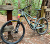
Photos
more »
Trail Lists
-
Bike Na - Skeggs Route (2 Cars)
12 trails
Routes with this trail
more »
-
+ 1
 Kidklayko
(Mar 20, 2022 at 21:13)
Kidklayko
(Mar 20, 2022 at 21:13)
If you go the way suggested the beginning has a sorta jump line, it's only like 3/4 mile but fast as hell, and the climb after isn't bad. Then the downhill kicks in again, but with a flowier feel, only after you climb back out.
[Reply]

 ethanromer
(Nov 6, 2017 at 17:20)
ethanromer
(Nov 6, 2017 at 17:20)
Nice downhill flowy trail with jumps and a minor climb. Recommended
[Reply]
Videos
more »
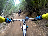
1:56 |
1081 |
Dec 8, 2013 , Redwood City
Nearby Trails
- Fir Trail (upper) 203 ft
- Tafoni Trail (upper) 545 ft
- Sierra Morena Trail 1,627 ft
- Manzanita Trail (upper) 4,426 ft
- Manzanita 4,852 ft
El Corte de Madera Creek Open Space Preserve
- embed El Corte de Madera Creek trail on your website
- By brenthillier
 NSMBA TRAILFORKS & contributors
 - #4905 - 5,310 views
- subscribe
- login to download gpx or kml files.