close
Trail Conditions
- Unknown
- Snow Groomed
- Snow Packed
- Snow Covered
- Snow Cover Inadequate
- Freeze/thaw Cycle
- Icy
- Prevalent Mud
- Wet
- Variable
- Ideal
- Dry
- Very Dry
Trail Flow (Ridden Direction)
Trailforks scans users ridelogs to determine the most popular direction each trail is ridden. A good flowing trail network will have most trails flowing in a single direction according to their intension.
The colour categories are based on what percentage of riders are riding a trail in its intended direction.
The colour categories are based on what percentage of riders are riding a trail in its intended direction.
- > 96%
- > 90%
- > 80%
- > 70%
- > 50%
- < 50%
- bi-directional trail
- no data
Trail Last Ridden
Trailforks scans ridelogs to determine the last time a trail was ridden.
- < 2 days
- < 1 week
- < 2 weeks
- < 1 month
- < 6 months
- > 6 months
Trail Ridden Direction
The intended direction a trail should be ridden.
- Downhill Only
- Downhill Primary
- Both Directions
- Uphill Primary
- Uphill Only
- One Direction
Contribute Details
Colors indicate trail is missing specified detail.
- Description
- Photos
- Description & Photos
- Videos
Trail Popularity ?
Trailforks scans ridelogs to determine which trails are ridden the most in the last 9 months.
Trails are compared with nearby trails in the same city region with a possible 25 colour shades.
Think of this as a heatmap, more rides = more kinetic energy = warmer colors.
- most popular
- popular
- less popular
- not popular
ATV/ORV/OHV Filter
Max Vehicle Width
inches
Radar Time
x
Activity Recordings
Trailforks users anonymized public ridelogs from the past 6 months.
- mountain biking recent
- mountain biking (>6 month)
- hiking (1 year)
- moto (1 year)
Activity Recordings
Trailforks users anonymized public skilogs from the past 12 months.
- Downhill Ski
- Backcountry Ski
- Nordic Ski
Jump Magnitude Heatmap
Heatmap of where riders jump on trails. Zoom in to see individual jumps, click circles to view jump details.
Trails Deemphasized
Trails are shown in grey.
Only show trails with NO bikes.
Save the current map location and zoom level as your default home location whenever this page is loaded.
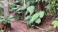
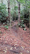
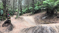
SaveWhakarewarewa Forest on the southern outskirts of Rotorua contains one of the oldest trail systems in the country. These master crafted trails have an unbeatable blend of proximity to the city centre, riding surfaces, topography, and they are surrounded by trees that have size and variety.
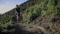
In 2011 and 2012 a major revamp of some of the trails in the original core network began after extensive logging in the forest. The Rotorua Mountain Bike Club started the work and the Rotorua Trails Trust took this over in 2015. The Trails Trust builds, rebuilds and maintains the trails. They are doing this with great success - improving the flow and making great trails even better. It's a major investment of time and dollars - but excellent value for money.
Some of the trails are also maintained by trail adopters and monthly volunteer working bees have all contributed to the work.
Access to the forest is free for riders however, a donation to the Rotorua Trails Trust is greatly appreciated and will help your trail karma.
source: Ride Rotorua
Primary Trail Type: All-Mountain & Downhill
eBikes Allowed:
Yes
Shuttleable: YES
AKA: Redwoods Forest
Land Status: Managed by Local Riding Association
 google parking directions
 Access Info:
The forest has multiple entry points including Waipa and Tarawera Road.
Waipa car park is on the south end of town off State Highway 5 and Waipa State Mill Road.
A new car park, called Te Putake o Tawa has opened off Tarawera Road near Okareka Loop Road.
Waipa car park is on the south end of town off State Highway 5 and Waipa State Mill Road.
A new car park, called Te Putake o Tawa has opened off Tarawera Road near Okareka Loop Road.
Links
Activities Click to view
- Mountain Bike
240 trails
- E-Bike
234 trails
- Hike
108 trails
- Trail Running
108 trails
- Horse
61 trails
Region Details
- 64
- 7
- 52
- 64
- 11
- 22
- 7
Region Status
Open as of May 22, 2022Local Trail Association
Stats
- Avg Trail Rating
- Trails (view details)
- 262
- Trails Mountain Bike
- 240
- Trails E-Bike
- 234
- Trails Hike
- 108
- Trails Trail Running
- 108
- Trails Horse
- 61
- Total Distance
- 198 miles
- Total Descent
- 44,570 ft
- Total Vertical
- 1,576 ft
- Highest Trailhead
- 2,525 ft
- Reports
- 9,632
- Photos
- 3,887
- Ridden Counter
- 214,470
Popular Whakarewarewa Forest Mountain Biking Trails
Whakarewarewa Forest Mountain Bike Routes
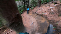
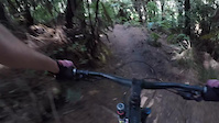
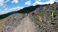
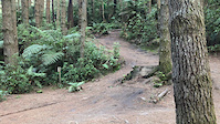
Photos of Whakarewarewa Forest Mountain Bike
trail: Mossy Loop
24 |
May 23, 2022 @ 4:36pm
May 23, 2022
trail: Katore Jumps
132 |
Jan 14, 2021 @ 10:29am
Jan 14, 2021
trail: Huckleberry Hound
135 | | 1 comments
Feb 14, 2019 @ 3:02pm
Feb 14, 2019
trail: Alternate Tokorangi Pa Road
155 |
Apr 24, 2017 @ 10:33pm
Apr 24, 2017
trail: Alternate Tokorangi Pa Road
116 |
Apr 24, 2017 @ 10:31pm
Apr 24, 2017
trail: Old Exit
459 |
Mar 23, 2017 @ 3:06am
Mar 23, 2017
trail: Old Exit
578 |
Mar 23, 2017 @ 3:06am
Mar 23, 2017
trail: Huckleberry Hound
537 | | 1 comments
Oct 9, 2016 @ 1:11am
Oct 9, 2016Videos of Whakarewarewa Forest Mountain Bike
trail: Tūteata
122 |
Apr 20, 2022
trail: Hot X Buns
95 |
Apr 6, 2022
trail: Split Enz
144 |
Dec 22, 2021
trail: Eastern Spice
|
Nov 14, 2021
trail: Taniwha National DH
228 |
Sep 19, 2021
trail: Taniwha National DH
164 |
Jul 31, 2021
trail: Katore Jumps
|
Mar 14, 2021
242 |
Feb 6, 2021
Current Trail Warnings
| status | trail | date | condition | user | info |
|---|---|---|---|---|---|
| Dual Slalom Track | Jun 25, 2022 @ 2:41pm Jun 25, 2022 | Dry | damosbike | In really bad condition. Mud, puddles, holes | |
| Tuhoto Ariki | Jun 17, 2022 @ 1:13pm Jun 17, 2022 | Prevalent Mud | rockroll | Very wet in places | |
| Hatu Patu | Jun 17, 2022 @ 1:13pm Jun 17, 2022 | Prevalent Mud | rockroll | Some bad ruts after last weekend |
Recent Trail Reports
| status | trail | date | condition | info | user |
|---|---|---|---|---|---|
| Box of Birds | Jul 5, 2022 @ 8:24pm 6 hours | Dry | Crawd | ||
| As You Do | Jul 5, 2022 @ 8:04pm 6 hours | Ideal | ScottFraser | ||
| As You Do - Not So Hard Line | Jul 5, 2022 @ 8:04pm 6 hours | Ideal | ScottFraser | ||
| Link: Katore Rd to Box Of Birds and K2 | Jul 5, 2022 @ 8:04pm 6 hours | Ideal | ScottFraser | ||
| Gunna Gotta | Jul 5, 2022 @ 8:04pm 6 hours | Variable | ScottFraser | ||
| Challenge DH | Jul 5, 2022 @ 8:04pm 6 hours | Variable | ScottFraser | ||
| Challenge Rockdrop Link | Jul 5, 2022 @ 8:04pm 6 hours | Variable | ScottFraser | ||
| Te Huinga | Jul 5, 2022 @ 8:04pm 6 hours | Variable | ScottFraser | ||
| New Exit | Jul 5, 2022 @ 8:04pm 6 hours | Variable | ScottFraser | ||
| Long Mile Road | Jul 5, 2022 @ 8:04pm 6 hours | Variable | ScottFraser |
Activity Feed
| username | action | type | title | date | |
|---|---|---|---|---|---|
 | nzdatto | wishlist | route | XTERRA Rotorua Long Course MTB 2022 (1 Lap) | Jul 6, 2022 @ 1:32am 1 hours |
 | ScottFraser | add | report | As You Do and 8 more | Jul 5, 2022 @ 10:14pm 4 hours |
| Crawd | add | report | As You Do and 1 more | Jul 5, 2022 @ 8:23pm 6 hours |
| TVM | add | report | Tumeke and 1 more | Jul 5, 2022 @ 6:08pm 8 hours |
| TracyRTT | add | report | Rockdrop and 1 more | Jul 5, 2022 @ 2:35pm 12 hours |
Recent Comments
| username | type | title | comment | date | |
|---|---|---|---|---|---|
 | trail | Pretty good argument for making this a G5.... | Jun 26, 2022 @ 4:53pm Jun 26, 2022 | ||
 | trail | Upper section is tight, muddy in the winter... | Jun 26, 2022 @ 1:07am Jun 26, 2022 | ||
| trail | A bit more singletrack on the side of the... | Jun 26, 2022 @ 12:52am Jun 26, 2022 | ||
| trail | Wide open steep DH sections and uphill climbs.... | Jun 26, 2022 @ 12:19am Jun 26, 2022 | ||
| trail | Slippery in the wet | Jun 25, 2022 @ 11:41pm Jun 25, 2022 |
Nearby Areas
| name | distance | ||||
|---|---|---|---|---|---|
| Te Ara Ahi | 3 | 2.1 km | |||
| Skyline - Rotorua | 1 | 4 | 5 | 5 | 5.3 km |
| Rainbow Mountain | 1 | 11.8 km | |||
| TECT All Terrain Park | 1 | 7 | 17.9 km | ||
| Cougar MTB Park | 6 | 19 | 1 | 20.3 km |
Local Badges
-

Completionist4 awarded
Bike & Skill Parks
| name | type | city | rating |
|---|---|---|---|
| Dodzy Skills Park | skill park | Rotorua | |
| Te Papa o Te Kauri BMX Track | skill park | Rotorua | |
| Wattles Dual Slalom Course | skill park | Rotorua |
Upcoming Local Events
Local Products
Local Products
Activity Type Stats
| activitytype | trails | distance | descent | descent distance | total vertical | rating | global rank | state rank | photos | reports | routes | ridelogs |
|---|---|---|---|---|---|---|---|---|---|---|---|---|
| Mountain Bike | 240 | 181 miles | 41,611 ft | 92 miles | 1,575 ft | #7 | #1 | 3,550 | 9,403 | 130 | 64,441 | |
| E-Bike | 234 | 179 miles | 40,236 ft | 90 miles | 1,575 ft | #2 | #1 | 31 | 8,664 | 29 | 3,187 | |
| Hike | 108 | 105 miles | 14,380 ft | 44 miles | 1,545 ft | #98 | #2 | 139 | 6,494 | 2 | 255 | |
| Trail Running | 108 | 102 miles | 13,888 ft | 42 miles | 1,545 ft | #92 | #2 | 118 | 6,515 | 5 | 2,944 | |
| Horse | 61 | 62 miles | 8,612 ft | 26 miles | 1,444 ft | #89 | #2 | 48 | 2,542 | 1 | 15 |
- By mbl77
 PCBC & contributors
 - Admins: kyleMichel, RTT, ArikiT
- #5641 - 79,489 views
- whakarewarewa forest activity log | embed map of Whakarewarewa Forest mountain bike trails | whakarewarewa forest mountain biking points of interest
Downloading of trail gps tracks in kml & gpx formats is enabled for Whakarewarewa Forest.
You must login to download files.