close
Trail Conditions
- Unknown
- Snow Groomed
- Snow Packed
- Snow Covered
- Snow Cover Inadequate
- Freeze/thaw Cycle
- Icy
- Prevalent Mud
- Wet
- Variable
- Ideal
- Dry
- Very Dry
Trail Flow (Ridden Direction)
Trailforks scans users ridelogs to determine the most popular direction each trail is ridden. A good flowing trail network will have most trails flowing in a single direction according to their intension.
The colour categories are based on what percentage of riders are riding a trail in its intended direction.
The colour categories are based on what percentage of riders are riding a trail in its intended direction.
- > 96%
- > 90%
- > 80%
- > 70%
- > 50%
- < 50%
- bi-directional trail
- no data
Trail Last Ridden
Trailforks scans ridelogs to determine the last time a trail was ridden.
- < 2 days
- < 1 week
- < 2 weeks
- < 1 month
- < 6 months
- > 6 months
Trail Ridden Direction
The intended direction a trail should be ridden.
- Downhill Only
- Downhill Primary
- Both Directions
- Uphill Primary
- Uphill Only
- One Direction
Contribute Details
Colors indicate trail is missing specified detail.
- Description
- Photos
- Description & Photos
- Videos
Trail Popularity ?
Trailforks scans ridelogs to determine which trails are ridden the most in the last 9 months.
Trails are compared with nearby trails in the same city region with a possible 25 colour shades.
Think of this as a heatmap, more rides = more kinetic energy = warmer colors.
- most popular
- popular
- less popular
- not popular
ATV/ORV/OHV Filter
Max Vehicle Width
inches
Radar Time
x
Activity Recordings
Trailforks users anonymized public ridelogs from the past 6 months.
- mountain biking recent
- mountain biking (>6 month)
- hiking (1 year)
- moto (1 year)
Activity Recordings
Trailforks users anonymized public skilogs from the past 12 months.
- Downhill Ski
- Backcountry Ski
- Nordic Ski
Jump Magnitude Heatmap
Heatmap of where riders jump on trails. Zoom in to see individual jumps, click circles to view jump details.
Trails Deemphasized
Trails are shown in grey.
Only show trails with NO bikes.
Save the current map location and zoom level as your default home location whenever this page is loaded.
SaveSituated deep in the Wairoa Valley, ‘The Gorge’ is home to an amazing variety of hand-built mountain bike trails that run through a lush native and beech forest environment from a maximum elevation of 1100m
Book Gorge Shuttles here https://www.thegorge.nz/
Book Gorge Shuttles here https://www.thegorge.nz/
Primary Trail Type: All-Mountain & Downhill
eBikes Allowed:
Yes
Shuttleable: YES
AKA: The Gorge
Land Status: Regional Recreation Area
 google parking directions
 Access Info:
Go to https://www.thegorge.nz/ for directions to get here
Links
Files
Region Supporters & Maintainers
trail builderSponsor
Activities Click to view
- Mountain Bike
62 trails
- E-Bike
55 trails
- Hike
5 trails
- Trail Running
3 trails
Bike Park Details
- 5
- 17
- 27
- 12
- 3
Region Status
Open as of Feb 24, 2022- Day Ticket
- 120 NZD
- Uplift Type
- Shuttle
Stats
- Avg Trail Rating
- Trails (view details)
- 62
- Trails Mountain Bike
- 62
- Trails E-Bike
- 55
- Trails Hike
- 5
- Trails Trail Running
- 3
- Trails ATV/ORV/OHV
- 4
- Total Distance
- 48 miles
- Total Descent
- 32,191 ft
- Total Vertical
- 3,049 ft
- Highest Trailhead
- 3,635 ft
- Reports
- 2,197
- Photos
- 778
- Ridden Counter
- 9,500
 Articles

Video: Tom Bradshaw Rides New Zealand’s Privately Built Bike Park
Feb 22, 2022 from pinkbike.com
Tom shows you why The Gorge in New Zealand is his favourite place in the world to ride trail bikes.
Popular "The Gorge" Mountain Bike Park Trails
Photos of "The Gorge" Mountain Bike Park Mountain Bike
trail: Devil's Armor
13 |
May 8, 2022 @ 8:08pm
May 8, 2022
trail: Snakes & Ladders
18 |
Apr 8, 2022 @ 1:17am
Apr 8, 2022
trail: Bermed As
9 |
Nov 17, 2021 @ 5:43pm
Nov 17, 2021
trail: Bermed As
10 |
Nov 17, 2021 @ 5:43pm
Nov 17, 2021
trail: Red Line
15 |
Nov 17, 2021 @ 5:43pm
Nov 17, 2021
trail: Bermed As
25 |
Jun 27, 2020 @ 9:23pm
Jun 27, 2020
trail: Bermed As
24 |
Jun 27, 2020 @ 9:23pm
Jun 27, 2020
trail: Screaming Turtle
22 |
Jun 27, 2020 @ 9:23pm
Jun 27, 2020Videos of "The Gorge" Mountain Bike Park Mountain Bike

trail: Bermed As
3:48 |
449 |
Jul 5, 2017
2:56 |
443 |
Dec 14, 2010
youtuber
![Slippery Weka | CHUNKY Tech at Wairoa Gorge]()
trail: Slippery Weka
6:31 |
49 |
May 4, 2022 , Nelson
youtuber
![Free Range | HIGH-SPEED Tech at Wairoa Gorge]()
trail: Free Range
5:58 |
147 |
Apr 29, 2022 , Nelson
youtuber
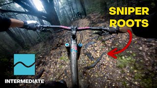
![Snakes & Ladders | WOODEN FEATURES &...]()

trail: Snakes & Ladders
3:28 |
46 |
Apr 24, 2022 , Nelson

youtuber
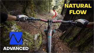
![Chase the Orange | PLAYFUL Flow at Wairoa Gorge]()
trail: Chase The Orange
2:40 |
58 |
Apr 14, 2022 , Nelson
youtuber
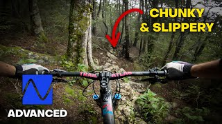
![Screaming Turtle | Technical CHAOS at Wairoa Gorge]()
trail: Screaming Turtle
7:40 |
67 |
Apr 9, 2022 , Nelson
Recent Trail Reports
| status | trail | date | condition | info | user |
|---|---|---|---|---|---|
| TNT | Apr 13, 2022 @ 10:14pm Apr 13, 2022 | Dry | GregNelson WGBP | ||
| Barrys carpark, access road and 4wd river crossing | Feb 28, 2022 @ 5:49pm Feb 28, 2022 | Ideal | GregNelson WGBP | ||
| Muppet road | Feb 28, 2022 @ 5:49pm Feb 28, 2022 | Ideal | GregNelson WGBP | ||
| Snakes & Ladders | Feb 28, 2022 @ 5:49pm Feb 28, 2022 | Ideal | GregNelson WGBP | ||
| Florence | Sep 3, 2021 @ 3:07am Sep 3, 2021 | Dry | GregNelson WGBP | ||
| Sewer Sidle | May 21, 2021 @ 7:53pm May 21, 2021 | Dry | jimbob79 AKDH | ||
| Instant Kiwi | May 21, 2021 @ 6:41pm May 21, 2021 | Dry | jimbob79 AKDH | ||
| Natural Selection | May 21, 2021 @ 6:40pm May 21, 2021 | Dry | jimbob79 AKDH | ||
| Steel Pancake | Apr 20, 2021 @ 7:57pm Apr 20, 2021 | Dry | Haggiss | ||
| Pro Cut Line | Apr 18, 2021 @ 11:51pm Apr 18, 2021 | Dry | Harby WGTV |
Activity Feed
| username | action | type | title | date | |
|---|---|---|---|---|---|
 | ewestrupp | comment | report | Road To Nowhere and 3 more | Jul 6, 2022 @ 1:38am 53 mins |
| ewestrupp | comment | report | Road To Nowhere | Jul 5, 2022 @ 7:19pm 7 hours |
 | BelindaCrisp | add | report | Nigh Nigh's | Jul 5, 2022 @ 1:48pm 13 hours |
| tawamtbr | ridden | trail | Free Range and 3 more | Jul 4, 2022 @ 6:30pm 1 day |
| ewestrupp | add | report | Road To Nowhere | Jul 3, 2022 @ 8:21pm 2 days |
Recent Comments
| username | type | title | comment | date | |
|---|---|---|---|---|---|
| report | Job completed | Jul 6, 2022 @ 1:47am 45 mins | ||
| report | Job completed | Jul 6, 2022 @ 1:44am 48 mins | ||
| report | Job completed | Jul 6, 2022 @ 1:41am 51 mins | ||
| report | Job completed | Jul 6, 2022 @ 1:38am 53 mins | ||
| report | Job completed | Jul 5, 2022 @ 7:19pm 7 hours |
Nearby Areas
| name | distance | ||||
|---|---|---|---|---|---|
| Aniseed Valley | 3 | 10.4 km | |||
| Richmond Hills | 7 | 12.3 km | |||
| Silvan Forest | 6 | 17 | 1 | 13.1 km | |
| Moutere Hills Forest | 14.2 km | ||||
| Marsden Valley | 1 | 4 | 15.2 km |
Local Badges
-

Completionist0 awarded
Local Trail Supporters
- GregNelson
- Greg McIntyre
![]()
Pinkbike Articles
Feb 22, 2022
 Video: Tom Bradshaw Rides New Zealand’s Privately Built Bike Park
Tom shows you why The Gorge in New Zealand is his favourite place in the world to ride trail bikes.
Activity Type Stats
| activitytype | trails | distance | descent | descent distance | total vertical | rating | global rank | state rank | photos | reports | routes | ridelogs |
|---|---|---|---|---|---|---|---|---|---|---|---|---|
| Mountain Bike | 62 | 48 miles | 32,192 ft | 30 miles | 3,048 ft | #627 | #27 | 774 | 2,196 | 1,515 | ||
| E-Bike | 55 | 42 miles | 27,684 ft | 25 miles | 3,048 ft | #198 | #12 | 1,357 | 30 | |||
| Hike | 5 | 5 miles | 1,007 ft | 3 miles | 2,589 ft | #10,140 | #196 | 1,179 | 24 | |||
| Trail Running | 3 | 4 miles | 653 ft | 2 miles | 2,589 ft | #10,094 | #195 | 1,171 | 1 | |||
| ATV/ORV/OHV | 4 | 6 miles | 764 ft | 1 mile | 2,575 ft | 357 |
- By GregNelson
 WGBP WGS & contributors
 - Admins: Aorere-Enduro, NMTBC, WGBP, WGS, TGOM, ewestrupp, mikeynelson
- #16458 - 15,690 views
- "the gorge" mountain bike park activity log | embed map of "The Gorge" Mountain Bike Park mountain bike trails | "the gorge" mountain bike park mountain biking points of interest
-
- subscribe
- 3d map
Downloading of trail gps tracks in kml & gpx formats is enabled for "The Gorge" Mountain Bike Park.
You must login to download files.