
Words: Todd Neumarker
With the Spring riding season in full swing here in North America, the Trailforks crew wanted to give users a quick update on recent developments. We've added some new features to help riders quickly see which trails are ready to ride. We know full well that trail reports are better in some locations then others, so we added new features that work in addition to trail reports along with this how-to.
This is the season where trail conditions are changing daily. Some are drying out fast as summer approaches while others are closing down with intermittent rain showers. Now is the perfect time to update trail conditions on Trailforks. A lot of our pro subscribers and local riders tend to know their area dry patterns, but this is more about saving trails for everyone by letting all trail users know where NOT to go. This allows our precious trail builders and trail associations to work on new trails instead of repairing old ones.
Start by Checking Conditions
If you are planning your trip at home or using the app there are a few ways you can check trail conditions in your area. Trailforks provides live style overlays that are powered by our user community. Trail reports and activity recordings power these live styles to provide users with up-to-date information on trails. Currently we provide these 3 tools: • Trail Style - Conditions (Web and App)
• Trail Style - Last Ridden (Web Only)
• Trail Activity Logs (Web and App)
• Trail Style - Last Ridden (Web Only)
• Trail Activity Logs (Web and App)
Trail Style - CONDITIONS
By default this will display all trails according to the latest condition report in the system. You also have the option to filter it by the latest reports. If it recently rained or you are unsure of conditions, play with the filters, and plan your ride accordingly. I know my local trails pretty well, and they are close by, so I'm most interested in how high up the mountain I can ride before I encounter mud or snow.
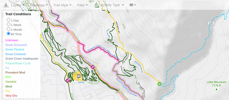
+NEW FEATURE
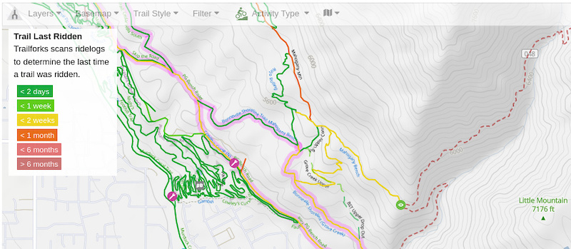
Trail Style - LAST RIDDEN
Another option is to view trails based on recent traffic. Another live style that Trailforks provides (currently web only), is the ability to paint the map according to when a trail was Last Ridden. This live style will color the map according to the last time someone recorded their activity on a per trail basis. So even if a report was not filed, you are able to get a sense of what is being ridden. This should not be used as a definitive guide on what is "Good to Go", but is yet another way to get a sense of trail conditions. From my example below, I'm very interested in this "Red" trail that nobody has ridden yet this year.
+PRO TIP
App - LAST RIDDEN
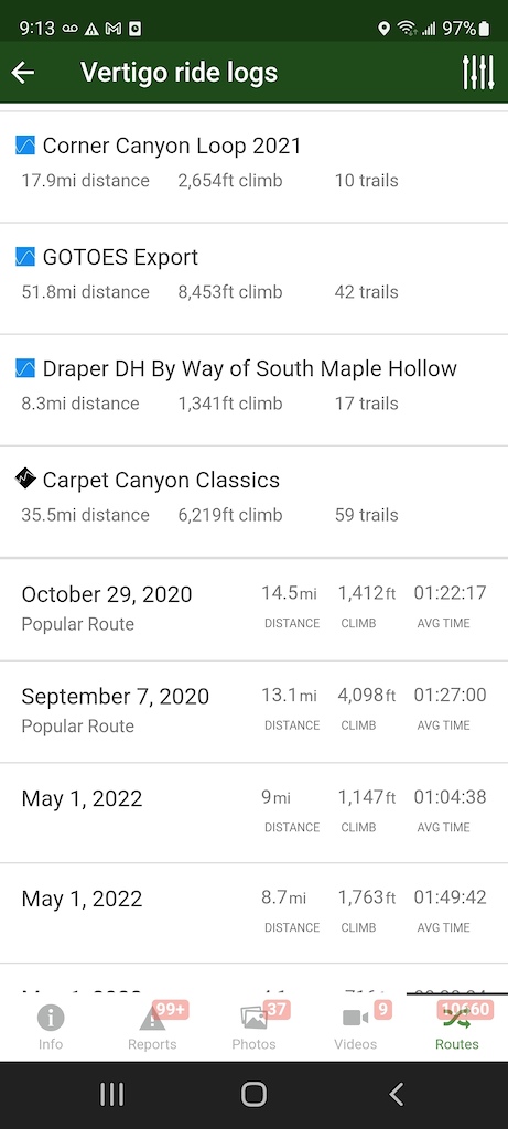
In the app there is a trick you can use to check a specific trail, to see if it may be ready to ride. If I'm interested to know if the flow trails on the south side of Corner Canyon are ready to ride, I can select the trail and look at all the most recent rides by selecting "Routes"
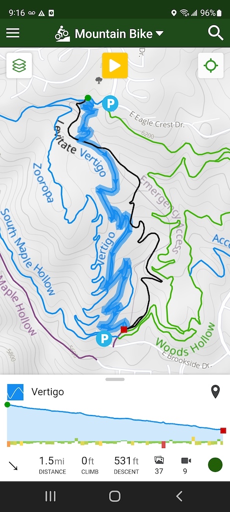
App - LAST RIDDEN
In the app there is a trick you can use to check a specific trail, to see if it may be ready to ride. If I'm interested to know if the flow trails on the south side of Corner Canyon are ready to ride, I can select the trail and look at all the most recent rides by selecting "Routes"
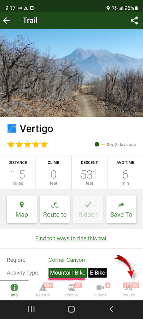
10660 Routes?
That does seem like a bit too many routes. That is because the routes list includes the following items in this order:
• Locally created favorite Routes
• Automatically Generated Popular Routes
• Most Recent Activity Logs
The tip here, is to scroll down past all the user created routes and generated popular routes, and take a look at the last time the trail was ridden. Location and trail popularity will vary here, but seeing several recent rides can give you an idea of the trail has been used recently.
This is NOT a definitive source, but will provide you with a bit more confidence before you decide to pack up the car and spend the effort to get to the trail system.
+NEW FEATURE
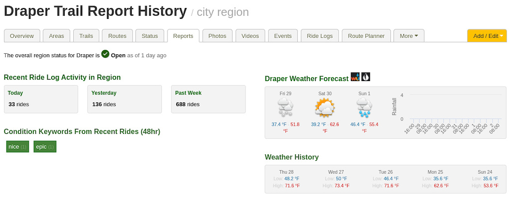
Weather History
The sun is shining, conditions look perfect for a ride, but what about the past few days? Trails take time to dry out, and your typical weather app doesn't readily tell you if it rained in the past few days. I can generally remember if it rained near my home, but what about the trail system that is an hour away, or at a slightly higher elevation? Some times the weather for me is perfect in the valley but rained a bit up north. Trailforks now records and keeps track of daily weather in over 1000 major regions so that you can "Look back in time" by location to see when it last rained:
Record your Activity in Trailforks
Updating trail condition status is easier than ever in Trailforks now, since we can detect which trails you have ridden. You can report on trail conditions right from the trail, after your ride, or bulk submit trail conditions for all trails you rode. This is made possible when you use the Trailforks App to record your ride.
Why record my ride in Trailforks?
Trail Condition Style
Last Ridden Style
Trail Statistics
Quickly see where you’ve already ridden. Confirming which trails you rode gives you a better sense of the local trail distances, so you can make better decisions on what to do next:
• Is there time to extend my loop?
• Fastest way back to trailhead?
• Is there time to extend my loop?
• Fastest way back to trailhead?
Trail Condition Style
If you ride with the “Condition Trail Style” on, you can avoid trails that have been marked as muddy and avoid them. Trailforks will paint the trails according to the last report that was submitted
Last Ridden Style
By simply recording your ride and being a good steward of your local trail system (staying off of muddy/closed trails), other riders can see that the trail has been ridden recently using the “Last Ridden” web style.
Trail Statistics
Trail associations, land owners, cities and trail-centric tourism boards can review the trail usage statistics. Providing trail builders information on which trails are ridden the most and the directional flow enables better planning and better trail systems. These recordings also feed the Trailforks live style layers to help all users plan the perfect day on the trails.
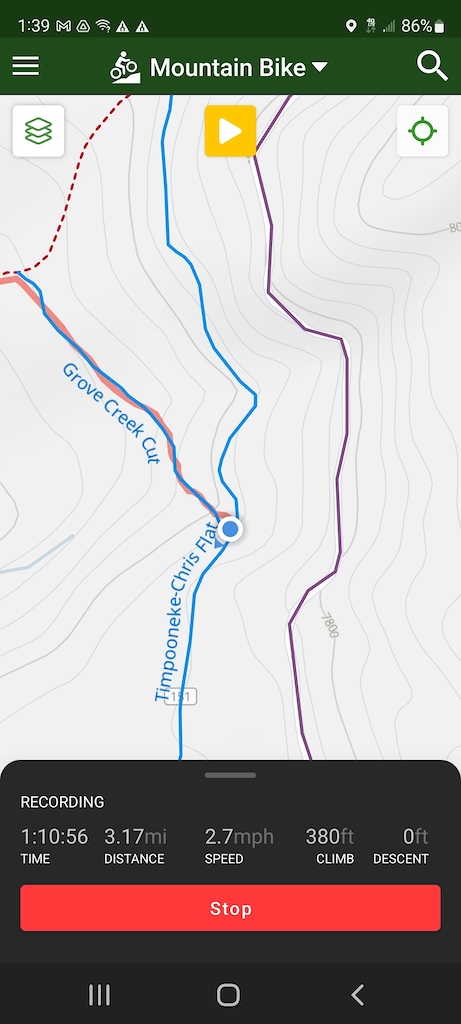
The easiest way to report trail status is to start recording your activity in the Trailforks App
Hit the Trail
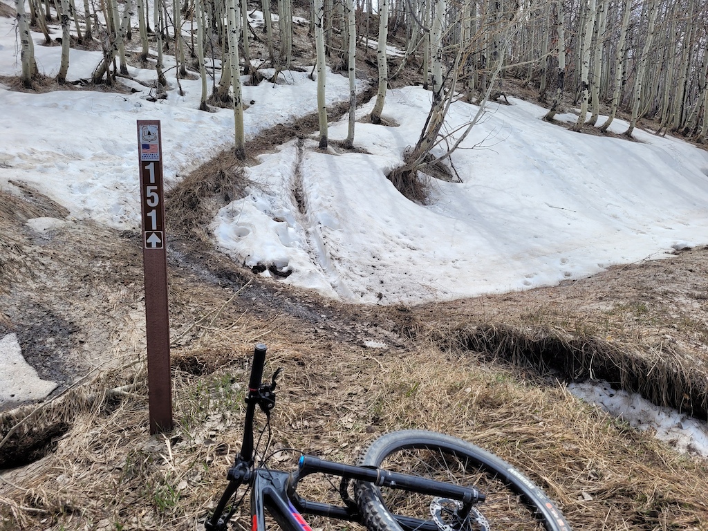
Once the app is recording it will track which trails you riding on. If you encounter mud or otherwise poor riding conditions you can update the condition right from the app. Trailforks will already know which trail your on, so you need only need to select the condition. It also helps other users to know when a trail is "ideal" for riding. This may be location dependent. For the ride I'm reporting on, nice tacky dirt is considered prime, but just having the grass matted down from late snow-melt also puts this trail status squarely in the "Ideal" category.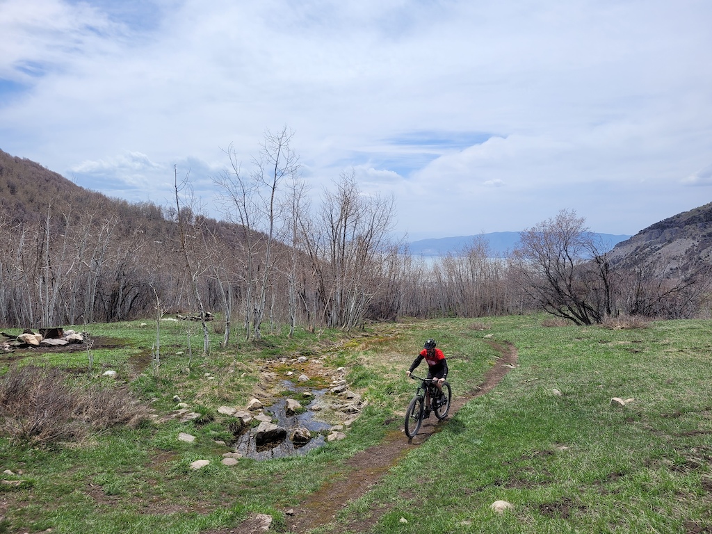
First Trail is "Ideal"

Mud Encountered
Muddy Condition Report
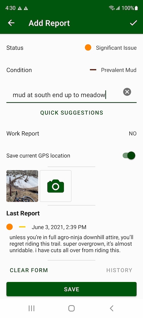
My goal was to ride this specific trail, but since the whole length was perfect, why not continue up until I reach the snow line. Once I got high enough and deep enough into the trees, I finally encountered snow and mud. I took a report photo, but did not submit it because I was pretty far away from home. I was ready to get home and eat lunch, I could add the report then.
This is where I "pad up" and send it back to the trailhead. Once I reach the car, I stop my ride recording and I have completed the "Trifecta":
• Which trail is in prime shape
• Which trail is too muddy to ride
• Trail was last ridden updated
• Which trail is too muddy to ride
• Trail was last ridden updated
Trail users looking for the best current options, and more importantly what trails NOT to hit.
Bulk Report
If you recorded your activity, Trailforks will do its best to detect all the trails you rode. On the website, you can review your ride details by selecting "My Ride Log", if you are mountain biking. For hiking, it will appear as "My Hike Log".
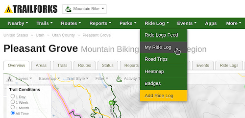
Select "My Ride Log", then select the date that you want to review. If you just completed your ride, it should be listed at the top of the list. Select the activity log by the date to see a full summary of your ride.

[add trail reports from this ride]
From here you will be provided with a list of all the trails you rode, and you can update conditions all at once.
Going the Extra Mile
At this point the conditions are all updated, and you did your part to keep singletrack single and rut-free. Any condition report photos will now be assigned to that trail with a special "Report" tag. Report photos are sorted to the bottom of any trail photo tab so that they can be used for historical reference. We also encourage you to upload any trail photos and assign them to the trail for the benefit of all Trailforks users.Thanks for reading! Download Trailforks today to get the latest trail conditions. I'll be sticking around for a few minutes to answer some questions in the comments.