Some of the most iconic routes exist as a loosely connected series of trails that may span hundreds or even thousands of miles. Countries, States, and Provinces all over the world are proud of their official routes that often span multiple mountain ranges, some extending from border to border and often taking on the name of their particular region or state. To help you plan and tackle your bucket list of adventures, we have put together a shortlist of these trails and routes that inspired this new feature. We have added highlighting and tools to both document and visualize these National Scenic Trails.
 Outside provides many great long form articles both online and in print, like this article on Backpacker.com:
While not all of these trails are officially designated as National Scenic Trails, nor are they even called that, we have grouped them under that moniker to make them easily recognizable and generally well understood to users in the thru-hike and bikepack community. We considered calling them “Official Trails”, but felt the need to highlight the fact that these routes have been created by dedicated cartographers and explorers not affiliated with our website. As we have been documenting these routes over the past year, it is clear that every one of these "Trails" could easily be designated as "Scenic". The name seems to fit, and from here on out, we will refer to them by the simple and relatively unique acronym of “NST”.
These trails are beyond "trails", perhaps even beyond the term "route", as they often cannot be traversed in a single day. All of them are broken up into segments, and may even include point-to-point shuttles to bypass natural land formations and private property. National Scenic Trails often cross state boundaries, like the "Pacific Crest Trail" and "Continental Divide National Scenic Trail". Trails of this magnitude often require government involvement, like in the case of the Pacific Crest Trail, which was established in the US by an Act of Congress as part of the National Trail Systems Act of 1968
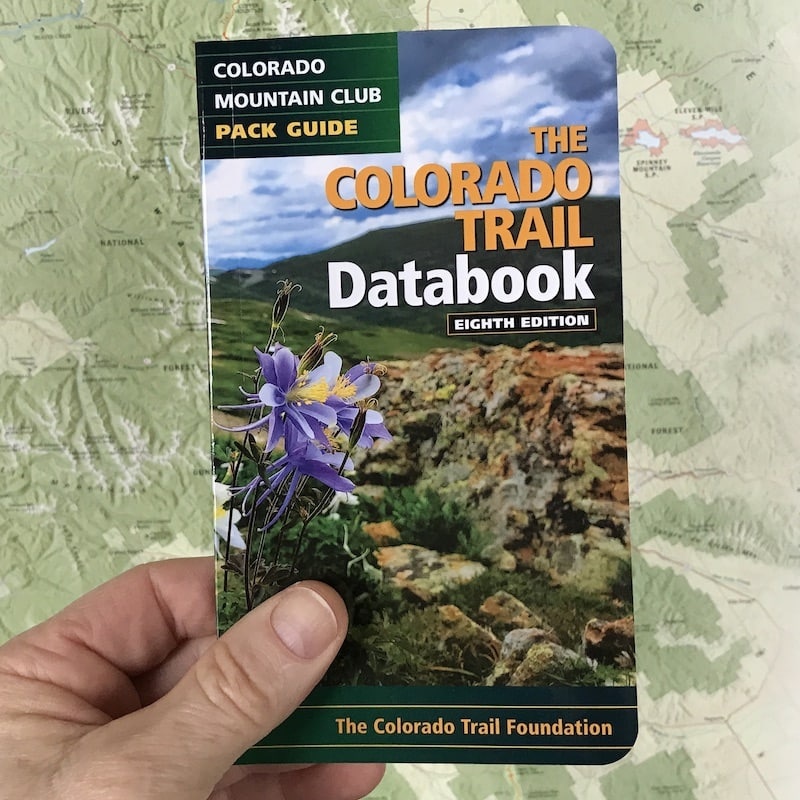
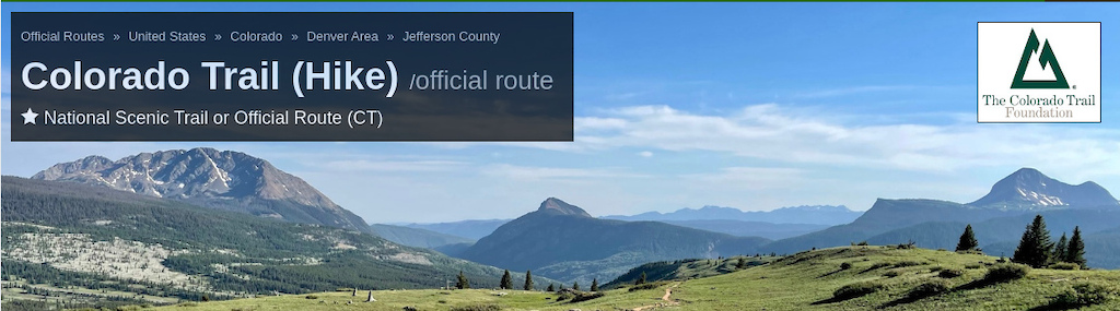
Each NST has it's own landing page, which provides an entry point to start planning your adventure. These landing pages provide a complete elevation profile for the entire length of the route. All photos that are assigned to trails along the route are compiled and displayed here as well, so that you can see what's in store. We also provide a table of all the included trails with links, status, ratings and a quick button to check each trail off your list. We really love the Colorado Trail, and for demonstration purposes it provides that perfect mix of Hike/Bike specific reroutes, well documented segment names, in addition to multiple overlaps with another NST: The Continental Divide Trail.
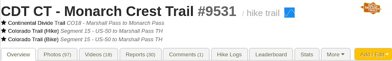
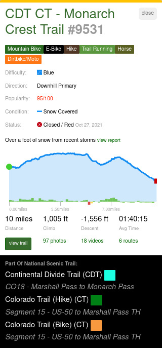 The amount of information from a single trail can be overwhelming sometimes. As anyone who has experienced the Monarch Crest on a busy day, can attest, the trail gets lots of visitors. Not only is it a stunning trail, but it is open to hikers, equestrians, bikes, and dirt bikes. It also shares a part with both the Colorado Trail (CT) and the Continental Divide Trail (CDT).
One click on the website or in the app:
• Title Denoting Shared NST (CDT CT)
• Trail Usages Allowed
• Trail Vital Information
• Trail Status (Based upon most recent report)
• Elevation
• Media Links (Photos, Videos, Detected Routes)
• NST Associations
These "National Scenic Trails" exist all over the world, and while some are specific to activity types, many can be traversed using both "non-mechanized" like hiking (and equestrian), via "mechanized", and even motorized. In the US, there are several routes which simply require alternate routes for mechanized and motorized traversal. The CT and the CDT both pass through several designated wilderness areas, which do not allow bikes. This means the type of activity selected may require a different NST to be displayed or to no display an NST that is dedicated to a different activity.
In Australia there are 2 National Scenic Routes in Western Australia that provide a hike option and a bike option in a similar way. The hiking-only route is called the "Munda Biddi Trail", while bike packers have the option to ride the "Bibbulmun Track".
NST routes do not have to be fully connected end-to-end like a traditional route. If the reroutes are small enough, simply adding the reroute as a spur trail is easily accomplished. For extensive routes like the 2 mentioned above, it makes sense to provide a completely separate NST route along with it's own landing page to provide information specific to the way in which users plan to traverse the route.
The National Scenic Trail map layers and route pages are now live on both the website and app, so you can start planning your summer adventures now. Put together your bucket list weeklong expedition or plan out weekend trips to tick off some of the iconic trails closer to home.
Quick Preface
Example: Colorado Trail - Guide Book
Before we dive into this new feature, it is important to emphasize this is a tool should be used in conjunction with official guides and print material. There are many excellent guidebooks, paper maps, and long form articles that highlight the beauty and detail of the routes. One of our favorite aspects of this feature, is the ability to see how these iconic trails interact with the many other complex trail systems they traverse. Seeing how they overlap, intersect and change based upon your favorite form of locomotion, be it hike, horse, bike, or motorized. Many of these routes are incomprehensibly arduous, and we believe this is another useful piece of equipment, whether you are tackling the entire route, or including a small part on a long weekend.
Why call them all a "National Scenic Trail"?
While not all of these trails are officially designated as National Scenic Trails, nor are they even called that, we have grouped them under that moniker to make them easily recognizable and generally well understood to users in the thru-hike and bikepack community. We considered calling them “Official Trails”, but felt the need to highlight the fact that these routes have been created by dedicated cartographers and explorers not affiliated with our website. As we have been documenting these routes over the past year, it is clear that every one of these "Trails" could easily be designated as "Scenic". The name seems to fit, and from here on out, we will refer to them by the simple and relatively unique acronym of “NST”.
These trails are beyond "trails", perhaps even beyond the term "route", as they often cannot be traversed in a single day. All of them are broken up into segments, and may even include point-to-point shuttles to bypass natural land formations and private property. National Scenic Trails often cross state boundaries, like the "Pacific Crest Trail" and "Continental Divide National Scenic Trail". Trails of this magnitude often require government involvement, like in the case of the Pacific Crest Trail, which was established in the US by an Act of Congress as part of the National Trail Systems Act of 1968
Why we love this feature
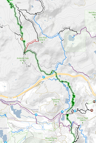
Pacific Crest Trail, Donner Pass, California
At Trailforks, we wanted a way to visualize these monumental routes from a high level, allowing app users to easily view how they connect through multiple independent trail systems. This will help not only in the planning and navigation of routes, but also will also indicate when app users are traversing even small parts of a route or trail. These trail systems can be loosely connected, some with long paved road sections in between short sections. By highlighting these on the map, users can easily find the trails specific to these National Scenic Trails and other Official Routes.
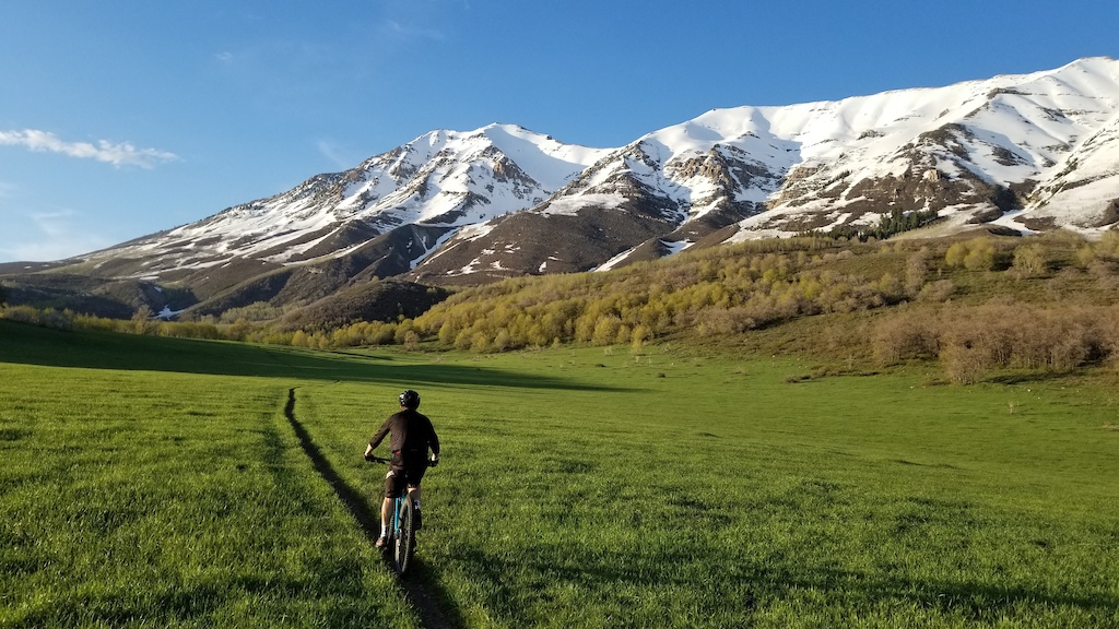
As much as I would love to take an entire summer off to hike the Pacific Crest Trail, like most working stiffs, relatively short sections over a long weekend is a more doable option. With both the "ultra-backpackers" and "weekenders" in mind, we added the ability to visualize the route along with any connected trail systems. This enables users to see how they might incorporate a part of one of these iconic routes into a loop or smaller route that may be part of a connected trail system. Now users can make short loops to get a taste of an NST or plan specific segments as day trips. Here you can see how the Pacific Crest Trail cuts right through Donner Pass, providing easy access to one of the rocky high altitude sections right from the interstate.
As much as I would love to take an entire summer off to hike the Pacific Crest Trail, like most working stiffs, relatively short sections over a long weekend is a more doable option. With both the "ultra-backpackers" and "weekenders" in mind, we added the ability to visualize the route along with any connected trail systems. This enables users to see how they might incorporate a part of one of these iconic routes into a loop or smaller route that may be part of a connected trail system. Now users can make short loops to get a taste of an NST or plan specific segments as day trips. Here you can see how the Pacific Crest Trail cuts right through Donner Pass, providing easy access to one of the rocky high altitude sections right from the interstate.
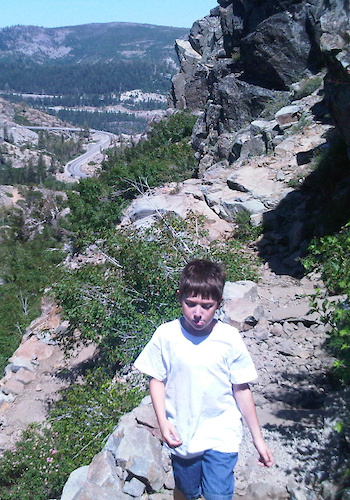
This is a favorite section of mine to hike as I travel the I-80 from where I grew up in California to Utah where I now call home. The trail maintainers at The Pacific Crest Trail Association have done some amazing trail work by using the abundance of granite rock to build a very pleasurable hike. The steep sections that climb from the summit consist of crafted steps that bring you up to sweeping views of Donner Lake and the surrounding rocky peaks.
Lake Tahoe has a lot of trails, and Donner Pass is a high point on the I-80 Highway. Using Trailforks, you can see exactly where you can connect to the PCT, get a short sampling off it, or tie it in with other connected trails to create your perfect loop. Then you can go home and say "I hiked the PCT this weekend".
Lake Tahoe has a lot of trails, and Donner Pass is a high point on the I-80 Highway. Using Trailforks, you can see exactly where you can connect to the PCT, get a short sampling off it, or tie it in with other connected trails to create your perfect loop. Then you can go home and say "I hiked the PCT this weekend".
Donner Pass PCT
Trailforks Visualization
Each NST has it's own landing page, which provides an entry point to start planning your adventure. These landing pages provide a complete elevation profile for the entire length of the route. All photos that are assigned to trails along the route are compiled and displayed here as well, so that you can see what's in store. We also provide a table of all the included trails with links, status, ratings and a quick button to check each trail off your list. We really love the Colorado Trail, and for demonstration purposes it provides that perfect mix of Hike/Bike specific reroutes, well documented segment names, in addition to multiple overlaps with another NST: The Continental Divide Trail.
One click on the website or in the app:
• Title Denoting Shared NST (CDT CT)
• Trail Usages Allowed
• Trail Vital Information
• Trail Status (Based upon most recent report)
• Elevation
• Media Links (Photos, Videos, Detected Routes)
• NST Associations
These "National Scenic Trails" exist all over the world, and while some are specific to activity types, many can be traversed using both "non-mechanized" like hiking (and equestrian), via "mechanized", and even motorized. In the US, there are several routes which simply require alternate routes for mechanized and motorized traversal. The CT and the CDT both pass through several designated wilderness areas, which do not allow bikes. This means the type of activity selected may require a different NST to be displayed or to no display an NST that is dedicated to a different activity.
Activity Types and Alternate Routes
Trailforks presents NST highlights specific to your activity mode. Dedicated Activity Types
Some routes are specific to your activity type. For example, the following routes are primarily for hikers (non-mechanized):
• Pacific Crest Trail (PCT)
• Superior Hiking Trail (SHT)
• Appalachian Trail (AT)
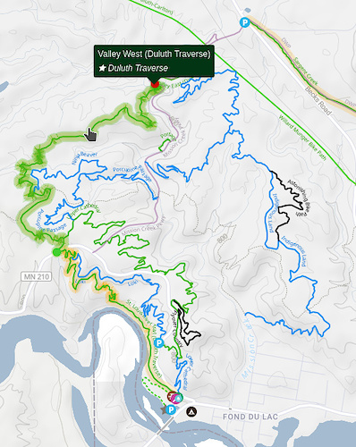
In Trailforks, these trails are highlighted automatically when you're in hike mode. They will not be displayed if you are in Mountain Bike mode because they simply do not apply. If you're riding your mountain bike in Duluth, instead of the Superior Hiking Trail, you will see the Duluth Traverse highlighted as shown in the map. Fancy a hike, switch your activity type, and the Superior Hiking Trail will be highlighted along with all the other context sensitive trail map theme changes.
Some routes are specific to your activity type. For example, the following routes are primarily for hikers (non-mechanized):
• Pacific Crest Trail (PCT)
• Superior Hiking Trail (SHT)
• Appalachian Trail (AT)
In Trailforks, these trails are highlighted automatically when you're in hike mode. They will not be displayed if you are in Mountain Bike mode because they simply do not apply. If you're riding your mountain bike in Duluth, instead of the Superior Hiking Trail, you will see the Duluth Traverse highlighted as shown in the map. Fancy a hike, switch your activity type, and the Superior Hiking Trail will be highlighted along with all the other context sensitive trail map theme changes.
In Australia there are 2 National Scenic Routes in Western Australia that provide a hike option and a bike option in a similar way. The hiking-only route is called the "Munda Biddi Trail", while bike packers have the option to ride the "Bibbulmun Track".
Activity Specific Reroutes
Many of these routes do not provide a unique path for each activity group. As we've seen, routes like the CDT provide reroutes, or variations of the same main line route to accommodate different activity types (non-mechanized, mechanized, motorized, etc.). Securing land permission, and building remote routes is difficult and maintaining fully separate routes by activity type is often not feasible. Again, back to our example routes:
• Colorado Trail (CT)
• Continental Divide Trail (CDT)
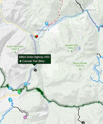
Both of these have large designated wilderness areas. The CT has a few rather long dirt and paved roads to get around the wilderness areas as shown to the left. The CDT has even bigger parks like Glacier National Park along with many wilderness areas that must be avoided by all mechanized usage. To facilitate this, we are documenting each route separately by activity type.
Many of these routes do not provide a unique path for each activity group. As we've seen, routes like the CDT provide reroutes, or variations of the same main line route to accommodate different activity types (non-mechanized, mechanized, motorized, etc.). Securing land permission, and building remote routes is difficult and maintaining fully separate routes by activity type is often not feasible. Again, back to our example routes:
• Colorado Trail (CT)
• Continental Divide Trail (CDT)
Both of these have large designated wilderness areas. The CT has a few rather long dirt and paved roads to get around the wilderness areas as shown to the left. The CDT has even bigger parks like Glacier National Park along with many wilderness areas that must be avoided by all mechanized usage. To facilitate this, we are documenting each route separately by activity type.
NST routes do not have to be fully connected end-to-end like a traditional route. If the reroutes are small enough, simply adding the reroute as a spur trail is easily accomplished. For extensive routes like the 2 mentioned above, it makes sense to provide a completely separate NST route along with it's own landing page to provide information specific to the way in which users plan to traverse the route.
Route Sections and Naming
The main part of this feature is documentation and how to best represent these routes in a common way. Many of these trails have their own trail name, while others are named after the NST, while yet others are given names denoting their start/end points. To facility this need for flexible naming, we have added the ability to add NST specific names for each trail. There is a main trail name and #, in addition to an unlimited number of subnames. When possible we use standardized section namesThe National Scenic Trail map layers and route pages are now live on both the website and app, so you can start planning your summer adventures now. Put together your bucket list weeklong expedition or plan out weekend trips to tick off some of the iconic trails closer to home.