close
Trail Conditions
- Unknown
- Snow Groomed
- Snow Packed
- Snow Covered
- Snow Cover Inadequate
- Freeze/thaw Cycle
- Icy
- Prevalent Mud
- Wet
- Variable
- Ideal
- Dry
- Very Dry
Trail Flow (Ridden Direction)
Trailforks scans users ridelogs to determine the most popular direction each trail is ridden. A good flowing trail network will have most trails flowing in a single direction according to their intension.
The colour categories are based on what percentage of riders are riding a trail in its intended direction.
The colour categories are based on what percentage of riders are riding a trail in its intended direction.
- > 96%
- > 90%
- > 80%
- > 70%
- > 50%
- < 50%
- bi-directional trail
- no data
Trail Last Ridden
Trailforks scans ridelogs to determine the last time a trail was ridden.
- < 2 days
- < 1 week
- < 2 weeks
- < 1 month
- < 6 months
- > 6 months
Trail Ridden Direction
The intended direction a trail should be ridden.
- Downhill Only
- Downhill Primary
- Both Directions
- Uphill Primary
- Uphill Only
- One Direction
Contribute Details
Colors indicate trail is missing specified detail.
- Description
- Photos
- Description & Photos
- Videos
Trail Popularity ?
Trailforks scans ridelogs to determine which trails are ridden the most in the last 9 months.
Trails are compared with nearby trails in the same city region with a possible 25 colour shades.
Think of this as a heatmap, more rides = more kinetic energy = warmer colors.
- most popular
- popular
- less popular
- not popular
ATV/ORV/OHV Filter
Max Vehicle Width
inches
Radar Time
x
Activity Recordings
Trailforks users anonymized public ridelogs from the past 6 months.
- mountain biking recent
- mountain biking (>6 month)
- hiking (1 year)
- moto (1 year)
Activity Recordings
Trailforks users anonymized public skilogs from the past 12 months.
- Downhill Ski
- Backcountry Ski
- Nordic Ski
Jump Magnitude Heatmap
Heatmap of where riders jump on trails. Zoom in to see individual jumps, click circles to view jump details.
Trails Deemphasized
Trails are shown in grey.
Only show trails with NO bikes.
Save the current map location and zoom level as your default home location whenever this page is loaded.
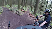
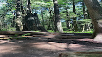
SaveThornhill is a long-established network of mixed use trails in Maple Ridge. Originally travelled by equestrian and then motorized users, as well as hikers, in more recent history the area has seen mountain-bike specific trails developed for riders of all ages and skills. These trails were originally unknowingly unauthorized, but are now 'on the map' and the popularity of the riding area is evident as to how popular the trails have become.
The climb is tame, the descents range from mellow blue, to big and boosty double-black, and all points in between. There is something for everyone at Thornhill.
As this is a multi-use trail network -> PLEASE NOTE: When encountering horses, the MTB rider should yield to the horse rider. Yielding to Equestrians: Bikers often scare horses. We are less familiar to them than hikers, so use caution. We recommend that as you approach an equestrian trail user you call out a friendly greeting from far away. Slow down too. You want to start talking from about 50-75 ft away if you can. Horses spook easily, so try asking how the person on the horse would like you to get by. Would they like you to get off and walk (this is great for horses that are really skittish) or should you pass slowly at the next safe spot? Respect for all trail users creates a healthy trail community.
Look for new signs that have been put in place. These signs have been put in place by the city of Maple Ridge with consultation from the Haney Horsemen Association and the Fraser Valley Mountain Bike Association. You will see signs at the bottoms of the downhill specific mountain trails that say "Downhill biking primary trail Expect to encounter bikes". Signs on very popular multi use trails will say "Shared Trail Expect to encounter horses/pedestrians/cyclists Walking speed only". Signs on long standing equestrian trails will say "Steep narrow trail section Cyclists must dismount and walk bikes" and "Horse Primary trail Cyclists must stop to allow horses to pass". And lastly there will be signs for the east side of the hill that has been built and developed for the hiking community these signs will say "Pedestrian trail only". These trails are still mostly unsanctioned and will be use at your own risk.
Primary Trail Type: All-Mountain & Downhill
eBikes Allowed:
No
AKA: Grant Hill, Thorn
Land Status: City Managed
Land Manager: City of Maple Ridge
 google parking directions
 Access Info:
Most start their ride at the gate on 256 Street and climb the road or Blazing Saddles. Alternately, you can start your ride at the cul de sac on 248 Street and climb Bear Ridge. Please be mindful of speed limits on surrounding streets and neighborhoods.
Disclaimer:
Use trails at your own risk. No unauthorized trail building, maintenance or modifications permitted. Please be mindful of speed limits on surrounding streets and neighborhoods
Activities Click to view
- Mountain Bike
26 trails
- Hike
33 trails
- Trail Running
33 trails
- Horse
18 trails
Region Details
- 3
- 3
- 5
- 12
- 1
- 2
Region Status
Caution as of Oct 23, 2021Stats
- Avg Trail Rating
- Trails (view details)
- 35
- Trails Mountain Bike
- 26
- Trails E-Bike
- 4
- Trails Hike
- 33
- Trails Trail Running
- 33
- Trails Horse
- 18
- Total Distance
- 15 miles
- Total Descent
- 3,095 ft
- Total Vertical
- 824 ft
- Highest Trailhead
- 1,089 ft
- Reports
- 1,846
- Photos
- 419
- Ridden Counter
- 17,236
Popular Thornhill Mountain Biking Trails
Thornhill Mountain Bike Routes
| title | rating | distance |
|---|---|---|
| SD43 Practice Enduro #2 | 4 miles | |
| 13 mile Thornhill Ride | popular ridelog | 13 miles |
| 6 mile Thornhill Ride | popular ridelog | 6 miles |
| 7 mile Thornhill Ride | popular ridelog | 7 miles |
| 6 mile Thornhill All-Mountain Ride | popular ridelog | 6 miles |
| 7 mile Thornhill Ride | popular ridelog | 7 miles |
| 10 mile Thornhill Ride | popular ridelog | 10 miles |
| 6 mile Thornhill All-Mountain Ride | popular ridelog | 6 miles |
| 7 mile Thornhill Downhill Ride | popular ridelog | 7 miles |
| 4 mile Thornhill All-Mountain Ride | popular ridelog | 4 miles |
Photos of Thornhill Mountain Bike
trail: Rip n' Dip
238 |
Nov 1, 2017 @ 11:04am
Nov 1, 2017
trail: Rip n' Dip
255 |
Nov 1, 2017 @ 11:04am
Nov 1, 2017
trail: Rip n' Dip
258 |
Nov 1, 2017 @ 11:03am
Nov 1, 2017
trail: Heads Up
124 |
Oct 31, 2017 @ 10:41pm
Oct 31, 2017
trail: O.S.R.
176 |
Aug 30, 2017 @ 9:48am
Aug 30, 2017Videos of Thornhill Mountain Bike
trail: Rip n' Dip
46 |
May 6, 2022
trail: Rip n' Dip
64 |
Apr 16, 2022
trail: Rip n' Dip
13 |
Apr 12, 2022

98 |
Mar 20, 2022
trail: Thornhill Trail
|
Jul 21, 2021
trail: Thornstar
|
Jul 8, 2021
trail: Thornstar
|
Jul 8, 2021
trail: Thornstar
|
Jul 8, 2021
Current Trail Warnings
| status | trail | date | condition | user | info |
|---|---|---|---|---|---|
| SHALAMALAMADINGDONG | Jun 30, 2022 @ 9:36pm Jun 30, 2022 | Very Dry | deanw | The trail is currently closed until trail... |
Recent Trail Reports
| status | trail | date | condition | info | user |
|---|---|---|---|---|---|
| Nick's | Jul 2, 2022 @ 8:47pm Jul 2, 2022 | Ideal | ryando FVMBA - REPORT | ||
| O.S.R. | Jul 2, 2022 @ 6:26am Jul 2, 2022 | Ideal | Chesttoufa9 | ||
| Thornstar | Jul 2, 2022 @ 6:05am Jul 2, 2022 | Ideal | Chesttoufa9 | ||
| Trail Dweller | Jul 2, 2022 @ 6:05am Jul 2, 2022 | Ideal | Chesttoufa9 | ||
| Access Road - The Price of Admission | Jun 24, 2022 @ 3:12pm Jun 24, 2022 | Ideal | karvanet | ||
| Access | Jun 24, 2022 @ 3:12pm Jun 24, 2022 | Ideal | karvanet | ||
| Rip n' Dip | Jun 24, 2022 @ 3:12pm Jun 24, 2022 | Ideal | karvanet | ||
| Flow Rider | Jun 16, 2022 @ 12:49pm Jun 16, 2022 | Ideal | italianjob777 | ||
| Heads Up | Jun 12, 2022 @ 10:42am Jun 12, 2022 | Variable | Dawgprimo15 | ||
| Blazing Saddles | Jun 12, 2022 @ 10:42am Jun 12, 2022 | Ideal | Dawgprimo15 |
Activity Feed
| username | action | type | title | date | |
|---|---|---|---|---|---|
 | Lobe76 | ridden | trail | Easy Going and 2 more | Jul 5, 2022 @ 10:00am 17 hours |
| Jseo15 | ridden | trail | Sessions | Jul 4, 2022 @ 10:49am 2 days |
 | ryando | add | report | Nick's | Jul 2, 2022 @ 8:47pm Jul 2, 2022 |
| BryansAPXsC | ridden | trail | Bear Ridge | Jul 2, 2022 @ 9:02am Jul 2, 2022 |
| Chesttoufa9 | add | report | Thornstar and 2 more | Jul 2, 2022 @ 6:05am Jul 2, 2022 |
Recent Comments
| username | type | title | comment | date | |
|---|---|---|---|---|---|
 | trail | Really fun trail! Thanks for building such a... | Apr 30, 2022 @ 4:34pm Apr 30, 2022 | ||
| report | Ha! - the trail is also in pretty good shape | Apr 10, 2022 @ 5:30pm Apr 10, 2022 | ||
 | trail | To add to chbarnes comment, I was taken out by... | Mar 6, 2022 @ 11:08pm Mar 6, 2022 | ||
| report | Rumor had it you guys were out there... | Mar 5, 2022 @ 9:26am Mar 5, 2022 | ||
 | report | Thanks For the Props! B-Roc | Mar 5, 2022 @ 8:50am Mar 5, 2022 |
Nearby Areas
| name | distance | ||||
|---|---|---|---|---|---|
| Glen Valley Trails | 1 | 2.7 km | |||
| Silver Valley | 9 | 4 | 4.4 km | ||
| Woodlot | 8 | 10 | 3 | 4.9 km | |
| Golden Ears Provincial Park | 1 | 1 | 1 | 6.4 km | |
| Stave West - Rolley Lake | 2 | 2 | 7.2 km |
Local Badges
-

Completionist14 awarded
Bike & Skill Parks
| name | type | city | rating |
|---|---|---|---|
| Maple Ridge MTB Skills Park | skill park | Maple Ridge |
Local Mountain Biking Directory
-
Maple Ridge CycleBike Shop
-
Trek Bicycle Maple RidgeBike Shop
-
Local RideBike Shop
Local Products
Local Trail Supporters
- Dean
![]()
- Ryan and Paul
Activity Type Stats
| activitytype | trails | distance | descent | descent distance | total vertical | rating | global rank | state rank | photos | reports | routes | ridelogs |
|---|---|---|---|---|---|---|---|---|---|---|---|---|
| Mountain Bike | 26 | 12 miles | 2,697 ft | 7 miles | 702 ft | #248 | #41 | 417 | 1,842 | 1 | 15,181 | |
| E-Bike | 4 | 3 miles | 243 ft | 4,140 ft | 630 ft | 1,258 | 513 | |||||
| Hike | 33 | 15 miles | 2,881 ft | 8 miles | 761 ft | #173 | #34 | 1 | 1,822 | 328 | ||
| Trail Running | 33 | 15 miles | 2,881 ft | 8 miles | 761 ft | #173 | #33 | 1,822 | 431 | |||
| Horse | 18 | 8 miles | 1,365 ft | 4 miles | 689 ft | #165 | #11 | 1 | 749 | 5 |
- By averyspacehall & contributors
- Admins: FVMBA - ADMIN, ali-chapple, lee5986, mtbmudhoney, Hams, tlgifford, PNVtrails, FVMBA - NORTH, FVMBA-Mission
- #4545 - 81,909 views
- thornhill activity log | embed map of Thornhill mountain bike trails | thornhill mountain biking points of interest
Downloading of trail gps tracks in kml & gpx formats is enabled for Thornhill.
You must login to download files.