close
Trail Conditions
- Unknown
- Snow Groomed
- Snow Packed
- Snow Covered
- Snow Cover Inadequate
- Freeze/thaw Cycle
- Icy
- Prevalent Mud
- Wet
- Variable
- Ideal
- Dry
- Very Dry
Trail Flow (Ridden Direction)
Trailforks scans users ridelogs to determine the most popular direction each trail is ridden. A good flowing trail network will have most trails flowing in a single direction according to their intension.
The colour categories are based on what percentage of riders are riding a trail in its intended direction.
The colour categories are based on what percentage of riders are riding a trail in its intended direction.
- > 96%
- > 90%
- > 80%
- > 70%
- > 50%
- < 50%
- bi-directional trail
- no data
Trail Last Ridden
Trailforks scans ridelogs to determine the last time a trail was ridden.
- < 2 days
- < 1 week
- < 2 weeks
- < 1 month
- < 6 months
- > 6 months
Trail Ridden Direction
The intended direction a trail should be ridden.
- Downhill Only
- Downhill Primary
- Both Directions
- Uphill Primary
- Uphill Only
- One Direction
Contribute Details
Colors indicate trail is missing specified detail.
- Description
- Photos
- Description & Photos
- Videos
Trail Popularity ?
Trailforks scans ridelogs to determine which trails are ridden the most in the last 9 months.
Trails are compared with nearby trails in the same city region with a possible 25 colour shades.
Think of this as a heatmap, more rides = more kinetic energy = warmer colors.
- most popular
- popular
- less popular
- not popular
ATV/ORV/OHV Filter
Max Vehicle Width
inches
Radar Time
x
Activity Recordings
Trailforks users anonymized public ridelogs from the past 6 months.
- mountain biking recent
- mountain biking (>6 month)
- hiking (1 year)
- moto (1 year)
Activity Recordings
Trailforks users anonymized public skilogs from the past 12 months.
- Downhill Ski
- Backcountry Ski
- Nordic Ski
Jump Magnitude Heatmap
Heatmap of where riders jump on trails. Zoom in to see individual jumps, click circles to view jump details.
Trails Deemphasized
Trails are shown in grey.
Only show trails with NO bikes.
Save the current map location and zoom level as your default home location whenever this page is loaded.
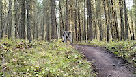
SaveWelcome to Fox Mountain
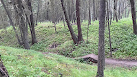
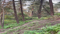
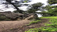
This is the longest standing trail network in Williams Lake and is host to some of the most stunning scenery in the Cariboo. The network has 28 trails totaling over 45Km of single track. The network is 28% beginner, 37% intermediate and 40% advanced.
All trails can be accessed via a nice climb up Jimmy’s Fox, Con Nino Y Pero, Skyline or by shuttling up Fox mountain Road. There are three trailheads on the network, all of which has a large Kiosk with maps and other information.
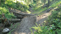
Foxfire was recently rebuilt in the summer of 2019 and is a fun flowy trail for the whole family. This can be access off the parking lot on Ross road. Upgrades were done also on Hillbilly Deluxe adding some fun intermediate wood stunts to this flowy trail.
Help support our trail network, purchase your Williams Lake Cycling Club membership here
This is the longest standing trail network in Williams Lake and is host to some of the most stunning scenery in the Cariboo. The network has 28 trails totaling over 45Km of single track. The network is 28% beginner, 37% intermediate and 40% advanced.
All trails can be accessed via a nice climb up Jimmy’s Fox, Con Nino Y Pero, Skyline or by shuttling up Fox mountain Road. There are three trailheads on the network, all of which has a large Kiosk with maps and other information.
Foxfire was recently rebuilt in the summer of 2019 and is a fun flowy trail for the whole family. This can be access off the parking lot on Ross road. Upgrades were done also on Hillbilly Deluxe adding some fun intermediate wood stunts to this flowy trail.
Help support our trail network, purchase your Williams Lake Cycling Club membership here
source: Ride the Cariboo
Primary Trail Type: All-Mountain & Downhill
Shuttleable: YES
 google parking directions
 Region Supporters & Maintainers
![]()
Ride The CaribooMaintainer
Activities Click to view
- Mountain Bike
51 trails
- Hike
45 trails
- Trail Running
45 trails
Region Details
- 2
- 13
- 19
- 14
- 3
Region Status
Caution as of Jul 1, 2022Stats
- Avg Trail Rating
- Trails (view details)
- 51
- Trails Mountain Bike
- 51
- Trails E-Bike
- 2
- Trails Hike
- 45
- Trails Trail Running
- 45
- Total Distance
- 33 miles
- Total Descent
- 11,586 ft
- Total Vertical
- 1,177 ft
- Highest Trailhead
- 3,258 ft
- Reports
- 997
- Photos
- 286
- Ridden Counter
- 5,767
Popular Fox Mountain Mountain Biking Trails
Fox Mountain Mountain Bike Routes
| title | rating | distance |
|---|---|---|
| TDC Centre Climbing Route | 4 miles | |
| The Quick Fox Loop | 6 miles | |
| Fox Staple - AK to Aflo | 2 miles | |
| 1.5 hr Fox Loop | 9 miles | |
| 13 km Fox Cruise | 8 miles | |
| 2016 Osprey BC Enduro Series | Williams Lake race | 19 miles | |
| 3 mile Fox Mountain Ride | popular ridelog | 3 miles |
| 3 mile Fox Mountain Ride | popular ridelog | 3 miles |
| 4 mile Fox Mountain All-Mountain Ride | popular ridelog | 4 miles |
| 6 mile Fox Mountain Ride | popular ridelog | 6 miles |
Photos of Fox Mountain Mountain Bike
trail: Loose Moose
20 |
Jun 13, 2022 @ 10:25am
Jun 13, 2022
trail: Loose Moose
25 |
Jun 13, 2022 @ 10:25am
Jun 13, 2022
trail: Loose Moose
25 |
Jun 10, 2022 @ 3:08pm
Jun 10, 2022
trail: Skyline
339 |
Mar 26, 2014 @ 9:28am
Mar 26, 2014
trail: Hillbilly Deluxe
742 |
Feb 13, 2013 @ 1:27pm
Feb 13, 2013
trail: Any Cog'll Do
964 | | 1 comments
Feb 13, 2013 @ 1:26pm
Feb 13, 2013
trail: Skyline
234 |
Jun 14, 2011 @ 7:24pm
Jun 14, 2011
trail: Hillbilly Deluxe
348 |
Jul 25, 2009 @ 2:29pm
Jul 25, 2009Videos of Fox Mountain Mountain Bike
trail: Wait Your Turn
84 |
Jul 13, 2021

trail: Wait Your Turn
67 |
Jul 13, 2021
trail: Wait Your Turn
74 |
Jul 13, 2021
trail: Any Cog'll Do
116 |
Jun 26, 2021
trail: Any Cog'll Do
102 |
Jun 13, 2021

trail: Shuttlebunny
0:34 |
108 |
Aug 6, 2020

trail: Shuttlebunny
0:08 |
127 |
Aug 6, 2020
trail: Shuttlebunny
0:10 |
196 |
Oct 2, 2019
Current Trail Warnings
| status | trail | date | condition | user | info |
|---|---|---|---|---|---|
| Any Cog'll Do | Jul 3, 2022 @ 10:16am 3 days | Prevalent Mud | fulty WLCC | A bit of a creek running down at the... | |
| Jimmys Fox | Jun 28, 2022 @ 5:01pm Jun 28, 2022 | Unknown | Chickenlewy WLCC | Some sections on the “old goat”... |
Recent Trail Reports
| status | trail | date | condition | info | user |
|---|---|---|---|---|---|
| GILF | Jul 1, 2022 @ 7:20am Jul 1, 2022 | Dry | RustyBrown | ||
| Foxfire | Jun 22, 2022 @ 5:44pm Jun 22, 2022 | Wet | Luna1989 | ||
| Loose Moose | Jun 18, 2022 @ 10:08am Jun 18, 2022 | Wet | TheSpangler WLCC | ||
| Con Nino Y Pero | Jun 12, 2022 @ 1:25pm Jun 12, 2022 | Dry | essencewl | ||
| Snap | Jun 12, 2022 @ 1:25pm Jun 12, 2022 | Ideal | essencewl | ||
| AK Connector | Jun 12, 2022 @ 1:25pm Jun 12, 2022 | Ideal | essencewl | ||
| Old Goat | Jun 12, 2022 @ 1:25pm Jun 12, 2022 | Ideal | essencewl | ||
| Skyline to OV | Jun 12, 2022 @ 1:25pm Jun 12, 2022 | Ideal | essencewl | ||
| Lazy Dog | Jun 3, 2022 @ 6:33pm Jun 3, 2022 | Variable | fulty WLCC | ||
| Hillbilly Deluxe | Jun 2, 2022 @ 12:40pm Jun 2, 2022 | Ideal | Hutchbiker |
Activity Feed
| username | action | type | title | date | |
|---|---|---|---|---|---|
 | Rogerbartels | ridden | route | 1.5 hr Fox Loop | Jul 5, 2022 @ 11:22am 15 hours |
 | fulty | add | report | Any Cog'll Do | Jul 4, 2022 @ 8:34am 2 days |
 | campasternak | wishlist | trail | Loose Moose | Jul 1, 2022 @ 9:00pm Jul 1, 2022 |
| RustyBrown | add | report | GILF | Jul 1, 2022 @ 7:20am Jul 1, 2022 |
 | TheSpangler | comment | report | Jimmys Fox | Jun 28, 2022 @ 6:38pm Jun 28, 2022 |
Recent Comments
| username | type | title | comment | date | |
|---|---|---|---|---|---|
| report | Thank you! | Jun 28, 2022 @ 6:38pm Jun 28, 2022 | ||
| report | Tree has been cleared | Apr 25, 2022 @ 3:02pm Apr 25, 2022 | ||
 | report | Cleared it | Mar 22, 2022 @ 8:08pm Mar 22, 2022 | ||
| report | Thank you! | Dec 21, 2021 @ 8:48am Dec 21, 2021 | ||
| trail | Tree down on the new part, at the very end... | Oct 10, 2021 @ 2:58pm Oct 10, 2021 |
Nearby Areas
| name | distance | ||||
|---|---|---|---|---|---|
| South Side | 1 | 28 | 7 | 2.9 km | |
| Chief Will Yum | 1 | 2 | 1 | 4.1 km | |
| Westsyde | 6 | 23 | 15 | 1 | 4.9 km |
| Desous | 3 | 4 | 11 | 1 | 12.5 km |
| Xat'sull - Soda Creek | 1 | 6 | 1 | 15.4 km |
Local Badges
-

Completionist2 awarded
Local Mountain Biking Directory
-
Williams Lake Cycling Club
![Williams Lake Cycling Club]()
-
Fox Mountain Brewing Co.
-
Ride The CaribooTrail Association
![Ride The Cariboo]()
-
Red Shreds Bike & Board shedBike Shop
![Red Shreds Bike & Board shed]()
Activity Type Stats
| activitytype | trails | distance | descent | descent distance | total vertical | rating | global rank | state rank | photos | reports | routes | ridelogs |
|---|---|---|---|---|---|---|---|---|---|---|---|---|
| Mountain Bike | 51 | 33 miles | 11,588 ft | 22 miles | 1,178 ft | #1,127 | #112 | 283 | 997 | 6 | 5,345 | |
| E-Bike | 2 | 2,644 ft | 269 ft | 2,290 ft | 427 ft | 737 | 1 | 67 | ||||
| Hike | 45 | 30 miles | 10,827 ft | 20 miles | 1,178 ft | #902 | #91 | 3 | 985 | 310 | ||
| Trail Running | 45 | 30 miles | 10,827 ft | 20 miles | 1,178 ft | #905 | #91 | 985 | 355 |
- By brenthillier
 NSMBA TRAILFORKS & contributors
 - Admins: CMBC, WLCC, RSTBC
- #3334 - 11,849 views
- fox mountain activity log | embed map of Fox Mountain mountain bike trails | fox mountain mountain biking points of interest polygons
Downloading of trail gps tracks in kml & gpx formats is enabled for Fox Mountain.
You must login to download files.