close
Trail Conditions
- Unknown
- Snow Groomed
- Snow Packed
- Snow Covered
- Snow Cover Inadequate
- Freeze/thaw Cycle
- Icy
- Prevalent Mud
- Wet
- Variable
- Ideal
- Dry
- Very Dry
Trail Flow (Ridden Direction)
Trailforks scans users ridelogs to determine the most popular direction each trail is ridden. A good flowing trail network will have most trails flowing in a single direction according to their intension.
The colour categories are based on what percentage of riders are riding a trail in its intended direction.
The colour categories are based on what percentage of riders are riding a trail in its intended direction.
- > 96%
- > 90%
- > 80%
- > 70%
- > 50%
- < 50%
- bi-directional trail
- no data
Trail Last Ridden
Trailforks scans ridelogs to determine the last time a trail was ridden.
- < 2 days
- < 1 week
- < 2 weeks
- < 1 month
- < 6 months
- > 6 months
Trail Ridden Direction
The intended direction a trail should be ridden.
- Downhill Only
- Downhill Primary
- Both Directions
- Uphill Primary
- Uphill Only
- One Direction
Contribute Details
Colors indicate trail is missing specified detail.
- Description
- Photos
- Description & Photos
- Videos
Trail Popularity ?
Trailforks scans ridelogs to determine which trails are ridden the most in the last 9 months.
Trails are compared with nearby trails in the same city region with a possible 25 colour shades.
Think of this as a heatmap, more rides = more kinetic energy = warmer colors.
- most popular
- popular
- less popular
- not popular
ATV/ORV/OHV Filter
Max Vehicle Width
inches
Radar Time
x
Activity Recordings
Trailforks users anonymized public ridelogs from the past 6 months.
- mountain biking recent
- mountain biking (>6 month)
- hiking (1 year)
- moto (1 year)
Activity Recordings
Trailforks users anonymized public skilogs from the past 12 months.
- Downhill Ski
- Backcountry Ski
- Nordic Ski
Jump Magnitude Heatmap
Heatmap of where riders jump on trails. Zoom in to see individual jumps, click circles to view jump details.
Trails Deemphasized
Trails are shown in grey.
Only show trails with NO bikes.
Save the current map location and zoom level as your default home location whenever this page is loaded.
SaveProbably the finest network of trails in South-East Asia - ok, after Chiang Mai
source: Trails Of Bukit Kiara
Primary Trail Type: All-Mountain & Downhill
AKA: Kiara
Land Status: Managed by Local Riding Association
 google parking directions
Links
Activities Click to view
- Mountain Bike
97 trails
- E-Bike
1 trails
- Hike
90 trails
- Trail Running
90 trails
Region Details
- 7
- 2
- 29
- 44
- 13
- 2
Region Status
Caution as of Jun 28, 2022Stats
- Avg Trail Rating
- Trails (view details)
- 97
- Trails Mountain Bike
- 97
- Trails E-Bike
- 1
- Trails Hike
- 90
- Trails Trail Running
- 90
- Total Distance
- 23 miles
- Total Descent
- 7,279 ft
- Total Vertical
- 687 ft
- Highest Trailhead
- 867 ft
- Reports
- 371
- Photos
- 490
- Ridden Counter
- 12,046
Popular Bukit Kiara Mountain Biking Trails
Bukit Kiara Mountain Bike Routes
| title | rating | distance |
|---|---|---|
| PCC PREZ 2015 race | 33 miles | |
| 12 mile Bukit Kiara Ride | popular ridelog | 12 miles |
| 9 mile Bukit Kiara Ride | popular ridelog | 9 miles |
| 10 mile Bukit Kiara Ride | popular ridelog | 10 miles |
| 9 mile Bukit Kiara Ride | popular ridelog | 9 miles |
| 10 mile Bukit Kiara Ride | popular ridelog | 10 miles |
| 9 mile Bukit Kiara Ride | popular ridelog | 9 miles |
| 7 mile Bukit Kiara Ride | popular ridelog | 7 miles |
| 7 mile Bukit Kiara Ride | popular ridelog | 7 miles |
| 6 mile Bukit Kiara Ride | popular ridelog | 6 miles |
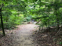
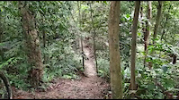
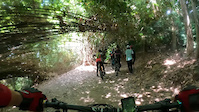
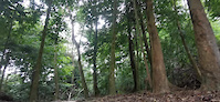
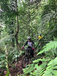
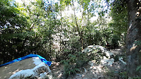
Photos of Bukit Kiara Mountain Bike
trail: Twin Peaks
0 |
Jun 30, 2022 @ 2:35am
Jun 30, 2022
trail: Twin Peaks
0 |
Jun 30, 2022 @ 2:35am
Jun 30, 2022
trail: Kawan-Kawan
4 |
Jun 26, 2022 @ 4:22am
Jun 26, 2022
trail: Apollo
2 |
Jun 20, 2022 @ 11:00pm
Jun 20, 2022
trail: Lower Carnival
4 |
Jun 6, 2022 @ 11:27pm
Jun 6, 2022
trail: Twin Peaks
6 |
May 17, 2022 @ 4:34am
May 17, 2022
trail: Snakes and Ladders
7 |
May 4, 2022 @ 10:22pm
May 4, 2022
trail: Boulder
12 |
May 3, 2022 @ 9:41pm
May 3, 2022Videos of Bukit Kiara Mountain Bike
trail: Shaolin
1 |
Jul 1, 2022

trail: 2K
6 |
May 30, 2022
11 |
Apr 13, 2022
trail: Twin Peaks
53 |
Jun 1, 2021
trail: Shaolin
54 |
Jan 12, 2021
trail: 4K Rubbish
42 |
Jan 6, 2021

trail: 4K Rubbish
37 |
Jan 6, 2021
trail: Shaolin
123 |
Nov 28, 2020
Recent Trail Reports
| status | trail | date | condition | info | user |
|---|---|---|---|---|---|
| Shaolin | Jun 28, 2022 @ 11:00am Jun 28, 2022 | Variable | Joe27 TRAKS | ||
| Kawan-Kawan | Jun 26, 2022 @ 2:36am Jun 26, 2022 | Variable | Joe27 TRAKS | ||
| 4K_ | Jun 21, 2022 @ 6:09pm Jun 21, 2022 | Dry | Choonsiong | ||
| Apollo | Jun 20, 2022 @ 5:48pm Jun 20, 2022 | Wet | Joe27 TRAKS | ||
| I.U.D | Jun 11, 2022 @ 7:04pm Jun 11, 2022 | Wet | kabel74 | ||
| Wasteland | May 28, 2022 @ 9:05pm May 28, 2022 | Variable | kabel74 | ||
| Salmon Run | May 28, 2022 @ 7:08pm May 28, 2022 | Variable | kabel74 | ||
| Lower C | May 28, 2022 @ 5:59pm May 28, 2022 | Wet | kabel74 | ||
| 2K | May 2, 2022 @ 8:55pm May 2, 2022 | Prevalent Mud | Joe27 TRAKS | ||
| The Mission | Apr 30, 2022 @ 8:09pm Apr 30, 2022 | Ideal | wleesh |
Activity Feed
| username | action | type | title | date | |
|---|---|---|---|---|---|
 | Joe27 | update | trail | Shaolin | Jul 2, 2022 @ 5:49pm Jul 2, 2022 |
| Joe27 | add | report | Shaolin | Jul 1, 2022 @ 7:01pm Jul 1, 2022 |
| Joe27 | add | photo | in Kuala Lumpur, Malaysia and 1 more | Jun 30, 2022 @ 6:22am Jun 30, 2022 |
 | jarst | wishlist | trail | Rubber Neck | Jun 28, 2022 @ 12:38am Jun 28, 2022 |
| Joe27 | add | photo | in Kuala Lumpur, Malaysia | Jun 26, 2022 @ 5:52am Jun 26, 2022 |
Recent Comments
| username | type | title | comment | date | |
|---|---|---|---|---|---|
| trail | 9 | Dec 12, 2020 @ 7:12pm Dec 12, 2020 | ||
| trail | Soft sand due to rain and fallen trees. Cannot... | Dec 23, 2019 @ 6:29pm Dec 23, 2019 | ||
| trail | Pair this trail with the 2K trail and you get... | Sep 4, 2018 @ 8:16pm Sep 4, 2018 | ||
| trail | Great trail to start your mountain bike journey | Sep 4, 2018 @ 8:15pm Sep 4, 2018 | ||
| report | Deadfall cleared three days after report was... | Sep 27, 2017 @ 6:27am Sep 27, 2017 |
Nearby Areas
| name | distance | ||||
|---|---|---|---|---|---|
| Kota Damansara Community Forest | 4 | 5 | 3.8 km | ||
| Bukit Dinding | 1 | 2 | 1 | 8.3 km | |
| Shah Alam Community Forest | 14 | 14 | 2 | 11 km | |
| Gombak | 1 | 11.1 km | |||
| Saujana Utama | 2 | 3 | 1 | 11.6 km |
Local Badges
-

Completionist0 awarded
Bike & Skill Parks
| name | type | city | rating |
|---|---|---|---|
| Whiplash Dirt Jump Trail | skill park | Kuala Lumpur |
Activity Type Stats
| activitytype | trails | distance | descent | descent distance | total vertical | rating | global rank | state rank | photos | reports | routes | ridelogs |
|---|---|---|---|---|---|---|---|---|---|---|---|---|
| Mountain Bike | 97 | 23 miles | 7,280 ft | 12 miles | 686 ft | #261 | #1 | 485 | 371 | 1 | 11,362 | |
| E-Bike | 1 | 1,089 ft | 26 ft | 318 ft | 118 ft | #1,509 | #2 | 273 | 171 | |||
| Hike | 90 | 22 miles | 6,568 ft | 11 miles | 686 ft | #189 | #1 | 4 | 364 | 931 | ||
| Trail Running | 90 | 22 miles | 6,568 ft | 11 miles | 686 ft | #191 | #1 | 1 | 364 | 2 | 552 |
- By Traks-Malaysia TRAKS & contributors
- Admins: TRAKS, TRAKS
- #5334 - 21,329 views
- bukit kiara activity log | embed map of Bukit Kiara mountain bike trails | bukit kiara mountain biking points of interest
-
- subscribe
- 3d map
Downloading of trail gps tracks in kml & gpx formats is enabled for Bukit Kiara.
You must login to download files.