Supporters, Builders, Maintainers & Land Managers of Twelvemile Meadow (South) Trail
USFSLand Manager
Details
-
Activities
- Mountain Bike
- E-Bike
- Hike
- Trail Running
- Horse
- Dirtbike/Moto
-
Riding AreaTwelvemile
Salmon, Idaho -
Ref Number#101
-
Difficulty Rating
-
Trail TypeSingletrack
-
Bike TypeAM, XC
-
DirectionDownhill PrimaryPopular direction shown
-
Trail VisibilitySometimes hard to follow
-
SeasonJune-Oct
-
Dogs AllowedYes
-
eBike Allowed
-
Global Ranking#61170 in Mountain Biking
-
Local Popularity85 in Mountain Biking [+]
- 5 in E-Biking
- 5 in Trail Running
- 5 in Hiking
- 5 in Dirtbiking
- 5 in Horseback
-
Land Manager
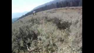
This trail is normally ridden downhill, often as part of the classic 'Twelvemile to Lime' ride. The upper trail runs through the Twelvemile Meadows, including thick sage and a large usually wet meadow. Riders "meadow-surf" down through this meadow. Stay on the crest or slightly right as you descend while finding good lines through the thick sage patches. Look to the right of the creek near the bottom of the meadow for the trail into the woods. Once in the trees the trail continues to descend along Meadow Creek and gets better and better.
This trail is open to motorcycles seasonally (5/22 to 9/7). The upper portion of this trail is within the Twelvemile Grazing Allotment. Grazing occurs in the Twelvemile Meadows unit during September of every other year.
Local Trail Association
-

-
-
Please consider joining or donating to the local trail association to supportdonate to earn trail karma!
trail development & maintenance.
Traditionally Indigenous Territory
More Stats for Twelvemile Meadow (South) mountain bike trail trail
-
Altitude change-1,357 ft
-
Altitude min6,802 ft
-
Altitude max8,160 ft
-
Altitude start8,159 ft
-
Altitude end6,801 ft
-
Grade-9.5%
-
Grade max-37.9%
-
Grade min1.6%
-
Distance climb433 ft
-
Distance down3 miles
-
Distance flat568 ft
-
Avg time00:46:05
- view trail stats
- Unknown
- Snow Groomed
- Snow Packed
- Snow Covered
- Snow Cover Inadequate
- Freeze/thaw Cycle
- Icy
- Prevalent Mud
- Wet
- Variable
- Ideal
- Dry
- Very Dry
The colour categories are based on what percentage of riders are riding a trail in its intended direction.
- > 96%
- > 90%
- > 80%
- > 70%
- > 50%
- < 50%
- bi-directional trail
- no data
- < 2 days
- < 1 week
- < 2 weeks
- < 1 month
- < 6 months
- > 6 months
- Downhill Only
- Downhill Primary
- Both Directions
- Uphill Primary
- Uphill Only
- One Direction
- Description
- Photos
- Description & Photos
- Videos
- most popular
- popular
- less popular
- not popular
- mountain biking recent
- mountain biking (>6 month)
- hiking (1 year)
- moto (1 year)
- Downhill Ski
- Backcountry Ski
- Nordic Ski
Save the current map location and zoom level as your default home location whenever this page is loaded.
SaveTwelvemile... Trail Reports
Recent Ridelog Activity on Trail
Past Week
- 2 rides
- 16 miles avg distance
6 Months
- 3 rides
- 16 miles avg distance
All
- 27 rides
Photos
Routes with this trail
Trail Products
-
 Idaho's Mountain Bike License PlateTrail Pass
 -

Links
Videos
Nearby Trails
- Meadow Connector 0 ft
- Da Luge 1 mile
- 12-horse Trail 1 mile
- Upper 12- Horse 2 miles
- 12 Ridge 2 miles
- embed Twelvemile Meadow (South) trail on your website
- By todd
 Trailforks & contributors
 - #14513 - 1,141 views
- subscribe
- login to download gpx or kml files.