close
Trail Conditions
- Unknown
- Snow Groomed
- Snow Packed
- Snow Covered
- Snow Cover Inadequate
- Freeze/thaw Cycle
- Icy
- Prevalent Mud
- Wet
- Variable
- Ideal
- Dry
- Very Dry
Trail Flow (Ridden Direction)
Trailforks scans users ridelogs to determine the most popular direction each trail is ridden. A good flowing trail network will have most trails flowing in a single direction according to their intension.
The colour categories are based on what percentage of riders are riding a trail in its intended direction.
The colour categories are based on what percentage of riders are riding a trail in its intended direction.
- > 96%
- > 90%
- > 80%
- > 70%
- > 50%
- < 50%
- bi-directional trail
- no data
Trail Last Ridden
Trailforks scans ridelogs to determine the last time a trail was ridden.
- < 2 days
- < 1 week
- < 2 weeks
- < 1 month
- < 6 months
- > 6 months
Trail Ridden Direction
The intended direction a trail should be ridden.
- Downhill Only
- Downhill Primary
- Both Directions
- Uphill Primary
- Uphill Only
- One Direction
Contribute Details
Colors indicate trail is missing specified detail.
- Description
- Photos
- Description & Photos
- Videos
Trail Popularity ?
Trailforks scans ridelogs to determine which trails are ridden the most in the last 9 months.
Trails are compared with nearby trails in the same city region with a possible 25 colour shades.
Think of this as a heatmap, more rides = more kinetic energy = warmer colors.
- most popular
- popular
- less popular
- not popular
ATV/ORV/OHV Filter
Max Vehicle Width
inches
Radar Time
x
Activity Recordings
Trailforks users anonymized public ridelogs from the past 6 months.
- mountain biking recent
- mountain biking (>6 month)
- hiking (1 year)
- moto (1 year)
Activity Recordings
Trailforks users anonymized public skilogs from the past 12 months.
- Downhill Ski
- Backcountry Ski
- Nordic Ski
Jump Magnitude Heatmap
Heatmap of where riders jump on trails. Zoom in to see individual jumps, click circles to view jump details.
Trails Deemphasized
Trails are shown in grey.
Only show trails with NO bikes.
Save the current map location and zoom level as your default home location whenever this page is loaded.
SaveKeystone area trails not including the Keystone Bike Park
Activities Click to view
- Mountain Bike
21 trails
- E-Bike
9 trails
- Hike
22 trails
- Trail Running
21 trails
- Horse
7 trails
- Dirtbike/Moto
11 trails
- Snowshoe
7 trails
- Downhill Ski
0 trails
- Backcountry Ski
0 trails
- Nordic Ski
6 trails
Region Details
- 6
- 6
- 8
Region Status
Caution as of May 10, 2020Stats
- Avg Trail Rating
- Trails (view details)
- 20
- Trails Mountain Bike
- 21
- Trails E-Bike
- 9
- Trails Hike
- 22
- Trails Trail Running
- 21
- Trails Horse
- 7
- Trails Dirtbike/Moto
- 11
- Trails Observed Trials
- 1
- Trails ATV/ORV/OHV
- 5
- Trails Snowshoe
- 7
- Trails Nordic Ski
- 6
- Total Distance
- 35 miles
- Total Descent
- 3,746 ft
- Total Vertical
- 2,894 ft
- Highest Trailhead
- 11,952 ft
- Reports
- 384
- Photos
- 51
- Ridden Counter
- 14,259
Popular Keystone Mountain Biking Trails
Keystone Mountain Bike Routes
| title | rating | distance |
|---|---|---|
| Keystone to Horseshoe Gulch via Witched Hippo | 22 miles | |
| Keystone Gulch | 13 miles | |
| 2020 K4-Mother | 41 miles | |
| Snake River Trail to Dillon Reservoir | 6 miles |
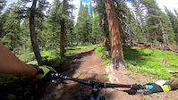
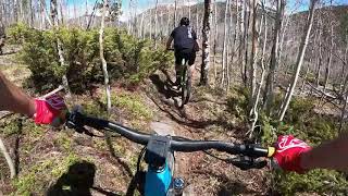
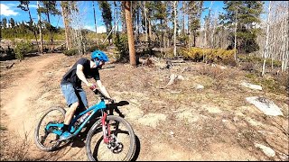
Photos of Keystone Mountain Bike
trail: Keystone Aqueduct Trail
5 |
Jun 13, 2022 @ 5:36am
Jun 13, 2022
trail: Keystone Aqueduct Trail
6 |
Jun 13, 2022 @ 5:36am
Jun 13, 2022
trail: West Ridge
51 |
Sep 15, 2021 @ 4:55pm
Sep 15, 2021
trail: Power Hair
33 |
Jun 10, 2021 @ 11:03am
Jun 10, 2021
trail: Keystone Aqueduct Trail
24 |
Jun 10, 2020 @ 1:35pm
Jun 10, 2020
trail: West Ridge
479 |
Nov 18, 2015 @ 9:47pm
Nov 18, 2015Videos of Keystone Mountain Bike
trail: West Ridge
3:23 |
178 |
Jul 29, 2019
trail: Furlough
2:27 |
133 |
May 9, 2020 , Keystone
trail: Furlough
0:55 |
117 |
May 9, 2020 , Keystone
Recent Trail Reports
| status | trail | date | condition | info | user |
|---|---|---|---|---|---|
| Keystone Aqueduct Trail | Jun 26, 2022 @ 8:24am Jun 26, 2022 | Dry | J4m3z420 SCoMBA | ||
| Gulch Connector | Jun 16, 2022 @ 10:55am Jun 16, 2022 | Dry | J4m3z420 SCoMBA | ||
| Granny's | Jun 16, 2022 @ 10:55am Jun 16, 2022 | Dry | J4m3z420 SCoMBA | ||
| Two Stump | Jun 11, 2022 @ 10:06am Jun 11, 2022 | Dry | J4m3z420 SCoMBA | ||
| West Ridge | Jun 11, 2022 @ 10:02am Jun 11, 2022 | Ideal | mdscherrer | ||
| Timbers Trail | Jun 5, 2022 @ 5:00am Jun 5, 2022 | Dry | J4m3z420 SCoMBA | ||
| Power Hair | May 26, 2022 @ 4:05pm May 26, 2022 | Dry | tarvisg Reporter | ||
| Powerline | May 19, 2022 @ 6:06pm May 19, 2022 | Dry | nolanvanharte Reporter | ||
| Incline | May 18, 2022 @ 10:58am May 18, 2022 | Dry | J4m3z420 SCoMBA | ||
| Seven of Nine | May 18, 2022 @ 10:58am May 18, 2022 | Dry | J4m3z420 SCoMBA |
Activity Feed
| username | action | type | title | date | |
|---|---|---|---|---|---|
 | KyleLBgq6 | wishlist | trail | Keystone Aqueduct Trail | Jul 4, 2022 @ 1:47pm 2 days |
| Klekkeratc | wishlist | trail | Keystone Gulch Rd (Lower) and 2 more | Jul 1, 2022 @ 7:19pm Jul 1, 2022 |
| jdieber | wishlist | route | Keystone to Horseshoe Gulch via Witched Hippo | Jun 28, 2022 @ 5:25pm Jun 28, 2022 |
| Cleon | wishlist | route | Keystone to Horseshoe Gulch via Witched Hippo | Jun 28, 2022 @ 9:42am Jun 28, 2022 |
| Henryy82tPz | ridden | trail | Two Stump | Jun 27, 2022 @ 10:50am Jun 27, 2022 |
Recent Comments
| username | type | title | comment | date | |
|---|---|---|---|---|---|
 | report | All clear all the way!! | May 16, 2022 @ 4:58pm May 16, 2022 | ||
| report | No worries… as always, the sooner we can... | May 13, 2022 @ 4:58pm May 13, 2022 | ||
 | report | Thank you! | May 13, 2022 @ 4:31pm May 13, 2022 | ||
| report | Thank you! | May 13, 2022 @ 4:30pm May 13, 2022 | ||
| trail | Trails new and needs to be riden in a bit.... | Jun 19, 2021 @ 7:12pm Jun 19, 2021 |
Local Badges
-

Big Ride 30k549 awarded -

Epic Ride Descent 2k445 awarded -

Completionist0 awarded -

Descent 10k Badge39 awarded -

Epic Ride Climb 2k74 awarded -

Climbing 10k Badge15 awarded
Activity Type Stats
| activitytype | trails | distance | descent | descent distance | total vertical | rating | global rank | state rank | photos | reports | routes | ridelogs |
|---|---|---|---|---|---|---|---|---|---|---|---|---|
| Mountain Bike | 21 | 35 miles | 3,747 ft | 11 miles | 2,894 ft | #2,293 | #993 | 51 | 384 | 4 | 1,925 | |
| E-Bike | 9 | 15 miles | 2,844 ft | 8 miles | 1,227 ft | #1,477 | #286 | 291 | 16 | |||
| Hike | 22 | 35 miles | 3,747 ft | 11 miles | 2,894 ft | #1,788 | #889 | 384 | 2 | 199 | ||
| Trail Running | 21 | 35 miles | 3,747 ft | 11 miles | 2,894 ft | #1,788 | #890 | 384 | 2 | 17 | ||
| Horse | 7 | 12 miles | 2,041 ft | 5 miles | 1,227 ft | #198 | #127 | 199 | 1 | 1 | ||
| Dirtbike/Moto | 11 | 19 miles | 2,848 ft | 8 miles | 2,277 ft | #86 | #58 | 220 | 7 | |||
| Observed Trials | 1 | |||||||||||
| ATV/ORV/OHV | 5 | 12 miles | 1,204 ft | 3 miles | 2,277 ft | 178 | ||||||
| Snowshoe | 7 | 6 miles | 1,499 ft | 3 miles | 1,204 ft | #103 | #64 | 194 | 1 | 4 | ||
| Nordic Ski | 6 | 6 miles | 1,499 ft | 3 miles | 1,204 ft | #53 | #36 | 190 | 108 |
- By J4m3z420
 SCoMBA & contributors
 - Admins: SCoMBA
- #4172 - 4,702 views
- keystone activity log | embed map of Keystone mountain bike trails | keystone mountain biking points of interest polygons
Downloading of trail gps tracks in kml & gpx formats is enabled for Keystone.
You must login to download files.