1.3 miles
Distance
3 ft
Climb
-550 ft
Descent
00:19:49
Avg time
Frank's Details
-
Activities
- Mountain Bike
- Hike
- Trail Running
-
Riding AreaBurke Mountain
Coquitlam, British Columbia -
Difficulty Rating
-
Hiking SAC ScaleT1 Hiking
-
Trail TypeSingletrack
-
Bike TypeAM, XC
-
DirectionDownhill PrimaryPopular direction shown
-
Climb DifficultyBlue
-
Physical RatingModerate
-
Trail VisibilityAlways easy to follow
-
Family FriendlyYes
-
Dogs AllowedYes
-
TTFs on TrailA-Frame, Bridge, Log Ride, Rock Garden, Skinny
-
Global Ranking
-
Local Popularity90 in Mountain Biking [+]
- 75 in Trail Running
- 85 in Hiking
One of the most popular trails on the mountain, Frank's is a low-grade downhill trail that is frequented by both XC riders and those wanting to progress their skillset. A great option to challenge yourself after conquering some of the lowest trails like Flow and Fluid.
This trail is unsanctioned.
Traditionally Indigenous Territory
More Stats for Frank's mountain bike trail trail
-
Altitude change-547 ft
-
Altitude min869 ft
-
Altitude max1,417 ft
-
Altitude start1,417 ft
-
Altitude end869 ft
-
Grade-7.8%
-
Grade max-52.8%
-
Grade min2%
-
Distance climb541 ft
-
Distance down1 mile
-
Distance flat505 ft
-
Avg time00:19:49
-
Avg reverse time00:36:40
- view trail stats
close
Trail Conditions
- Unknown
- Snow Groomed
- Snow Packed
- Snow Covered
- Snow Cover Inadequate
- Freeze/thaw Cycle
- Icy
- Prevalent Mud
- Wet
- Variable
- Ideal
- Dry
- Very Dry
Trail Flow (Ridden Direction)
Trailforks scans users ridelogs to determine the most popular direction each trail is ridden. A good flowing trail network will have most trails flowing in a single direction according to their intension.
The colour categories are based on what percentage of riders are riding a trail in its intended direction.
The colour categories are based on what percentage of riders are riding a trail in its intended direction.
- > 96%
- > 90%
- > 80%
- > 70%
- > 50%
- < 50%
- bi-directional trail
- no data
Trail Last Ridden
Trailforks scans ridelogs to determine the last time a trail was ridden.
- < 2 days
- < 1 week
- < 2 weeks
- < 1 month
- < 6 months
- > 6 months
Trail Ridden Direction
The intended direction a trail should be ridden.
- Downhill Only
- Downhill Primary
- Both Directions
- Uphill Primary
- Uphill Only
- One Direction
Contribute Details
Colors indicate trail is missing specified detail.
- Description
- Photos
- Description & Photos
- Videos
Trail Popularity ?
Trailforks scans ridelogs to determine which trails are ridden the most in the last 9 months.
Trails are compared with nearby trails in the same city region with a possible 25 colour shades.
Think of this as a heatmap, more rides = more kinetic energy = warmer colors.
- most popular
- popular
- less popular
- not popular
ATV/ORV/OHV Filter
Max Vehicle Width
inches
Radar Time
x
Activity Recordings
Trailforks users anonymized public ridelogs from the past 6 months.
- mountain biking recent
- mountain biking (>6 month)
- hiking (1 year)
- moto (1 year)
Activity Recordings
Trailforks users anonymized public skilogs from the past 12 months.
- Downhill Ski
- Backcountry Ski
- Nordic Ski
Jump Magnitude Heatmap
Heatmap of where riders jump on trails. Zoom in to see individual jumps, click circles to view jump details.
Trails Deemphasized
Trails are shown in grey.
Only show trails with NO bikes.
Save the current map location and zoom level as your default home location whenever this page is loaded.
Save
Directions to frank-s-8501 trailhead
(49.309390, -122.736630)
update trails status or condition
Frank's Trail Reports
view all reports »
Recent Ridelog Activity on Trail
Past Week
- 13 rides
- 8 miles avg distance
6 Months
- 263 rides
- 7 miles avg distance
All
- 2,897 rides
Technical Trail Features (TTF)
- A-frame ramp
 A-Frame
 - A-frame wood ramp over lo A-Frame
- Bridge

- Bridge Bridge
- Ladder Bridge Ladder Bridge
- Log & rock roll Drop
- Log bridge Bridge
- Log drop Drop
- Long log ride Log Ride
- Rock roll Rock Face
- Second Bridge
- Tree sign

- Wood ladder Ladder Bridge
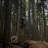
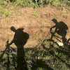
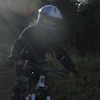
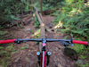
Photos
more »
Trail Lists
-
 PHMB Tri Cities - Intermediate Camps16 trails
 -
 PHMB Tri Cities - Advanced camps17 trails
Routes with this trail
more »
Trail Events
Trail Products
-
+ 1
DB87
 (Jun 8, 2022 at 17:11)
caution just ran into black bear on upper section mama bear for surely around
[Reply]
Chenzone
(Oct 29, 2021 at 12:55)
Don’t be fooled by the trail description, definitely not a downhill trail. I recommend getting off the trail and bushwhacking your way straight to the bottom.
[Reply]
 trail-governor
(Oct 30, 2021 at 0:03)
trail-governor
(Oct 30, 2021 at 0:03)
This is a classic xc trail
Don’t be fooled by silly comments
[Reply]
Don’t be fooled by silly comments
Ben19
(Jan 20, 2021 at 17:19)
First time riding Franks today, it has a substantial amount of climbing, certainly more than 16m. Just thought I’d point this out for other first timers, I’d almost call this an XC trail.
[Reply]
 TORCA-BIKES
Yes, but it’s best avoided during and after heavy rainfall.
[Reply]
jstromgren
BCBR (Nov 10, 2020 at 7:28)
Cleared of broad-leafs through middle section Nov 9/20
[Reply]
Hmichelis
(Jun 10, 2020 at 19:40)
Thanks to the trail fairies for giving upper Franks a much needed manicure! New woodwork is great, trail running nice and smooth. Cheers!
[Reply]
 ballisticpantz
Franks was in top form today. Dirt wasn't too dry (still some evidence of a puddle about 2/3 of the way down, rocks were sticky as heck, did that log ride tree in the first in third slow-mo to show da missus that I still got it (haha) and those old busted wooden features are GONE, nothing but you and the trail..GREAT job on marking the detour as well.
[Reply]
 northshoregurl
Super awesome fun trail,lots of twists and turns, in great condition, a bit dry and slippery. Has g great log ride (that I ride past) about 4-5 feet high but there is a go around. Definitely a more technical blue with a few challenging parts. Again super fun!
[Reply]
TORCA-BIKES
Frank's is open to the bottom, including a new connector that takes you to the Hustler exit to Harper Rd. Please follow the arrows and exit where directed. Wesbild has helped TORCA build this section of trail in order to keep riders away from the hairpin corner. Enjoy this new extension!!
[Reply]
DB87
(Oct 14, 2018 at 10:08)
Great trail but needs work on the upper section as areas are becoming over grown.
[Reply]
 madmattjames
(Sep 1, 2018 at 13:39)
madmattjames
(Sep 1, 2018 at 13:39)
Overgrown, covered in leaves, trees down across trail, wooden features rotten with nails sticking out.
[Reply]
Momthatrocks
(May 26, 2018 at 11:53)
If you choose to ignore construction signs at the top, take Frank’s Detour to get back to the road. Clear path all the way down today but you can see where trees are marked for future falling.
[Reply]
Dirtbaron
(May 14, 2018 at 8:57)
This trail was very sub par. Old school tight turns on most of the trail. The 2nd skinny is so overgrown the downramp is covered in prickles. Was not a fan of this trail personally.
[Reply]
 KevinStafford
(Nov 25, 2017 at 19:35)
KevinStafford
(Nov 25, 2017 at 19:35)
Greasy and covered with a carpet of leaves. The Earth is less loamy on Frank''s so expect to get a little muddy. There's some trees down in spots from the last blow that we had, to.
[Reply]
Videos
more »
youtuber
![Franks KOM | Burke Mountain, Coquitlam, BC | MTB]()

10:08 |
1156 |
May 31, 2020 , Coquitlam

2:58 |
108 |
Oct 5, 2021 , Coquitlam

6:53 |
110 |
Sep 21, 2021 , Coquitlam

5:29 |
198 |
Jun 15, 2020 , Coquitlam
Nearby Trails
- Bbt Connector 1,043 ft
- Slayer 1,165 ft
- Old Frank's 1,565 ft
- Big Boy Time 1,631 ft
- Dawg 2,014 ft
- embed Frank's trail on your website
- #8501 - 9,815 views