close
Trail Conditions
- Unknown
- Snow Groomed
- Snow Packed
- Snow Covered
- Snow Cover Inadequate
- Freeze/thaw Cycle
- Icy
- Prevalent Mud
- Wet
- Variable
- Ideal
- Dry
- Very Dry
Trail Flow (Ridden Direction)
Trailforks scans users ridelogs to determine the most popular direction each trail is ridden. A good flowing trail network will have most trails flowing in a single direction according to their intension.
The colour categories are based on what percentage of riders are riding a trail in its intended direction.
The colour categories are based on what percentage of riders are riding a trail in its intended direction.
- > 96%
- > 90%
- > 80%
- > 70%
- > 50%
- < 50%
- bi-directional trail
- no data
Trail Last Ridden
Trailforks scans ridelogs to determine the last time a trail was ridden.
- < 2 days
- < 1 week
- < 2 weeks
- < 1 month
- < 6 months
- > 6 months
Trail Ridden Direction
The intended direction a trail should be ridden.
- Downhill Only
- Downhill Primary
- Both Directions
- Uphill Primary
- Uphill Only
- One Direction
Contribute Details
Colors indicate trail is missing specified detail.
- Description
- Photos
- Description & Photos
- Videos
Trail Popularity ?
Trailforks scans ridelogs to determine which trails are ridden the most in the last 9 months.
Trails are compared with nearby trails in the same city region with a possible 25 colour shades.
Think of this as a heatmap, more rides = more kinetic energy = warmer colors.
- most popular
- popular
- less popular
- not popular
ATV/ORV/OHV Filter
Max Vehicle Width
inches
Radar Time
x
Activity Recordings
Trailforks users anonymized public ridelogs from the past 6 months.
- mountain biking recent
- mountain biking (>6 month)
- hiking (1 year)
- moto (1 year)
Activity Recordings
Trailforks users anonymized public skilogs from the past 12 months.
- Downhill Ski
- Backcountry Ski
- Nordic Ski
Jump Magnitude Heatmap
Heatmap of where riders jump on trails. Zoom in to see individual jumps, click circles to view jump details.
Trails Deemphasized
Trails are shown in grey.
Only show trails with NO bikes.
Save the current map location and zoom level as your default home location whenever this page is loaded.
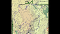
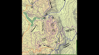
SavePVCA Mountain Bike Trails
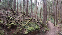
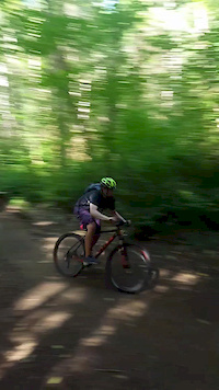
Snohomish County bought the land as a Conservation area (about 800 acres) for wildlife and wetlands protection around 2003 and closed access to the whole area. After several years and a lot of work primarily by local Mountain Bikers a portion of the area was re-opened with re-routed more environmentally friendly trails. The area consists of approx. 12 miles of trails although only about 9 miles of trails for biking. There are a few walking only trails ([please respect these) and 1 bike only trail but most trails are open to bikes, hiking and horses. The Mainline trail is fairly smooth but does have some light rooty sections and two slight hills, great for kids and beginners. It does not make a loop requiring either backtracking or taking other trails (which are much rootier and twistier) back to the main parking lot. Most of the other trails are fairly rooty with lots of twists and turns and only a few climb/descents. The trails are primarily somewhere between advanced beginner and intermediate in difficulty with the main challenge being roots, lots of exposed roots. Recent trails work in the past few years has eliminated much of the mud that had been a real issue during the winter here in the Pacific North Wet.
Snohomish County bought the land as a Conservation area (about 800 acres) for wildlife and wetlands protection around 2003 and closed access to the whole area. After several years and a lot of work primarily by local Mountain Bikers a portion of the area was re-opened with re-routed more environmentally friendly trails. The area consists of approx. 12 miles of trails although only about 9 miles of trails for biking. There are a few walking only trails ([please respect these) and 1 bike only trail but most trails are open to bikes, hiking and horses. The Mainline trail is fairly smooth but does have some light rooty sections and two slight hills, great for kids and beginners. It does not make a loop requiring either backtracking or taking other trails (which are much rootier and twistier) back to the main parking lot. Most of the other trails are fairly rooty with lots of twists and turns and only a few climb/descents. The trails are primarily somewhere between advanced beginner and intermediate in difficulty with the main challenge being roots, lots of exposed roots. Recent trails work in the past few years has eliminated much of the mud that had been a real issue during the winter here in the Pacific North Wet.
Primary Trail Type: Cross-Country
eBikes Allowed:
No
AKA: PVCA
Land Status: Conservation Reserve
 google parking directions
 Activities Click to view
- Mountain Bike
21 trails
- Hike
22 trails
- Trail Running
22 trails
Region Details
- 1
- 1
- 10
- 6
- 3
Region Status
Open as of May 21, 2022Local Trail Association
Stats
- Avg Trail Rating
- Trails (view details)
- 24
- Trails Mountain Bike
- 21
- Trails Hike
- 22
- Trails Trail Running
- 22
- Trails Horse
- 5
- Total Distance
- 11 miles
- Total Descent
- 816 ft
- Total Vertical
- 181 ft
- Highest Trailhead
- 510 ft
- Reports
- 1,310
- Photos
- 170
- Ridden Counter
- 12,674
Popular Paradise Valley Conservation Area Trails
Mountain Bike Routes
| title | rating | distance |
|---|---|---|
| Paradise Valley Enchilada Loop | 6 miles | |
| Cheryl's Fun Route | 6 miles | |
| All Dice | 7 miles | |
| Mainline Out and Back | 3 miles | |
| 5 mile Paradise Valley Conservation Area Ride | popular ridelog | 5 miles |
| 4 mile Paradise Valley Conservation Area Ride | popular ridelog | 4 miles |
| 9 mile Paradise Valley Conservation Area Ride | popular ridelog | 9 miles |
| 8 mile Paradise Valley Conservation Area Ride | popular ridelog | 8 miles |
| 11 mile Paradise Valley Conservation Area Ride | popular ridelog | 11 miles |
| 11 mile Paradise Valley Conservation Area All-Mountain Ride | popular ridelog | 11 miles |
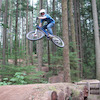
Photos of Paradise Valley Conservation Area Mountain Bike
trail: Cedar Run
24 |
Jan 3, 2022 @ 2:06pm
Jan 3, 2022
trail: Mainline Trail
22 |
Jan 3, 2022 @ 2:05pm
Jan 3, 2022
trail: Lloyd's Trail
58 |
Aug 28, 2021 @ 9:02pm
Aug 28, 2021
trail: Ephemeral
42 |
May 21, 2021 @ 11:00am
May 21, 2021
trail: Ephemeral
35 |
May 21, 2021 @ 10:59am
May 21, 2021
trail: Cedar Run
125 |
Jan 27, 2021 @ 10:13pm
Jan 27, 2021Videos of Paradise Valley Conservation Area Mountain Bike
trail: Twisted Hemlock
93 |
Apr 2, 2021
trail: Cedar Run
0:06 |
303 |
Jul 16, 2020
trail: Twisted Hemlock
1:24 |
322 |
Apr 25, 2017
trail: Cedar Run
0:55 |
879 |
Apr 25, 2017
trail: Red Alder
14:52 |
451 |
Jan 11, 2016
trail: Two Trees
17:13 |
147 |
Jan 11, 2016
trail: Cascara
14:09 |
244 |
Jan 11, 2016
trail: Mainline Trail
0:08 |
512 |
Oct 2, 2015
Recent Trail Reports
| status | trail | date | condition | info | user |
|---|---|---|---|---|---|
| 107th Street Trail | Jul 1, 2022 @ 10:24pm Jul 1, 2022 | Ideal | ceesar | ||
| Lloyd's Trail | Jul 1, 2022 @ 10:22pm Jul 1, 2022 | Dry | ceesar | ||
| Mainline Trail | Jul 1, 2022 @ 10:20pm Jul 1, 2022 | Dry | ceesar | ||
| Southern Traverse | Jul 1, 2022 @ 10:15pm Jul 1, 2022 | Dry | ceesar | ||
| Twisted Hemlock | Jun 23, 2022 @ 6:05am Jun 23, 2022 | Dry | Enellis4944 | ||
| Red Alder | Jun 20, 2022 @ 9:53pm Jun 20, 2022 | Ideal | ceesar | ||
| Two Trees | Jun 20, 2022 @ 9:50pm Jun 20, 2022 | Ideal | ceesar | ||
| Southern Traverse Climb | Jun 16, 2022 @ 9:26pm Jun 16, 2022 | Ideal | ceesar | ||
| Lloyd Detour | Jun 7, 2022 @ 7:05pm Jun 7, 2022 | Ideal | amckech | ||
| Mt. Bike Park (Little Ring) | May 27, 2022 @ 2:33pm May 27, 2022 | Ideal | n8ro |
Activity Feed
| username | action | type | title | date | |
|---|---|---|---|---|---|
 | merle | ridden | poi | Small Rock Drops | Jul 5, 2022 @ 11:45am 15 hours |
| merle | wishlist | route | All Dice | Jul 5, 2022 @ 10:11am 16 hours |
| ceesar | ridden | trail | Lloyd's Trail and 1 more | Jul 1, 2022 @ 10:22pm Jul 1, 2022 |
| ceesar | add | report | Southern Traverse and 3 more | Jul 1, 2022 @ 10:16pm Jul 1, 2022 |
| ceesar | checkin | trail | Southern Traverse and 3 more | Jul 1, 2022 @ 10:15pm Jul 1, 2022 |
Recent Comments
| username | type | title | comment | date | |
|---|---|---|---|---|---|
 | report | I cleared this today along with another one... | Nov 5, 2021 @ 1:52pm Nov 5, 2021 | ||
 | report | Unauthorized building has been a problem there... | Oct 26, 2021 @ 8:06pm Oct 26, 2021 | ||
| report | Wait, the gap got covered? | Aug 4, 2021 @ 10:46pm Aug 4, 2021 | ||
 | trail | Fun fun fun! Not sure how I missed this on my... | Jul 11, 2021 @ 3:08pm Jul 11, 2021 | ||
 | trail | Best trail in the network if it had jumps... | Jun 2, 2021 @ 5:56pm Jun 2, 2021 |
Nearby Areas
| name | distance | ||||
|---|---|---|---|---|---|
| Crystal Lake | 8 | 6 | 1.2 km | ||
| Lee Memorial Forest | 12 | 1 | 3 km | ||
| Tolt Pipeline | 1 | 3.6 km | |||
| Ring Hill Forest | 5 | 4.1 km | |||
| Lord Hill Regional Park | 25 | 15 | 1 | 5 km |
Local Badges
-

Completionist30 awarded
Local Products
Activity Type Stats
| activitytype | trails | distance | descent | descent distance | total vertical | rating | global rank | state rank | photos | reports | routes | ridelogs |
|---|---|---|---|---|---|---|---|---|---|---|---|---|
| Mountain Bike | 21 | 9 miles | 719 ft | 3 miles | 180 ft | #328 | #160 | 170 | 1,308 | 4 | 7,889 | |
| Hike | 22 | 11 miles | 659 ft | 3 miles | 180 ft | #284 | #168 | 1,237 | 3 | 144 | ||
| Trail Running | 22 | 11 miles | 659 ft | 3 miles | 180 ft | #286 | #167 | 1,237 | 2 | 137 | ||
| Horse | 5 | 5 miles | 236 ft | 1 mile | 121 ft | 522 |
- By jebike & contributors
- Admins: sanfret
- #5478 - 23,596 views
- paradise valley conservation area activity log | embed map of Paradise Valley Conservation Area mountain bike trails | paradise valley conservation area mountain biking points of interest
Downloading of trail gps tracks in kml & gpx formats is enabled for Paradise Valley Conservation Area.
You must login to download files.