close
Trail Conditions
- Unknown
- Snow Groomed
- Snow Packed
- Snow Covered
- Snow Cover Inadequate
- Freeze/thaw Cycle
- Icy
- Prevalent Mud
- Wet
- Variable
- Ideal
- Dry
- Very Dry
Trail Flow (Ridden Direction)
Trailforks scans users ridelogs to determine the most popular direction each trail is ridden. A good flowing trail network will have most trails flowing in a single direction according to their intension.
The colour categories are based on what percentage of riders are riding a trail in its intended direction.
The colour categories are based on what percentage of riders are riding a trail in its intended direction.
- > 96%
- > 90%
- > 80%
- > 70%
- > 50%
- < 50%
- bi-directional trail
- no data
Trail Last Ridden
Trailforks scans ridelogs to determine the last time a trail was ridden.
- < 2 days
- < 1 week
- < 2 weeks
- < 1 month
- < 6 months
- > 6 months
Trail Ridden Direction
The intended direction a trail should be ridden.
- Downhill Only
- Downhill Primary
- Both Directions
- Uphill Primary
- Uphill Only
- One Direction
Contribute Details
Colors indicate trail is missing specified detail.
- Description
- Photos
- Description & Photos
- Videos
Trail Popularity ?
Trailforks scans ridelogs to determine which trails are ridden the most in the last 9 months.
Trails are compared with nearby trails in the same city region with a possible 25 colour shades.
Think of this as a heatmap, more rides = more kinetic energy = warmer colors.
- most popular
- popular
- less popular
- not popular
ATV/ORV/OHV Filter
Max Vehicle Width
inches
Radar Time
x
Activity Recordings
Trailforks users anonymized public ridelogs from the past 6 months.
- mountain biking recent
- mountain biking (>6 month)
- hiking (1 year)
- moto (1 year)
Activity Recordings
Trailforks users anonymized public skilogs from the past 12 months.
- Downhill Ski
- Backcountry Ski
- Nordic Ski
Jump Magnitude Heatmap
Heatmap of where riders jump on trails. Zoom in to see individual jumps, click circles to view jump details.
Trails Deemphasized
Trails are shown in grey.
Only show trails with NO bikes.
Save the current map location and zoom level as your default home location whenever this page is loaded.
SaveActivities Click to view
- Mountain Bike
5 trails
- E-Bike
5 trails
Bike Park Details
- 1
- 1
- 2
- 1
Region Status
Open as of Jun 21, 2020- Day Ticket
- 25 EUR
- Uplift Type
- Shuttle
Stats
- Avg Trail Rating
- Trails (view details)
- 5
- Trails Mountain Bike
- 5
- Trails E-Bike
- 5
- Trails Hike
- 1
- Total Distance
- 3 miles
- Total Descent Distance
- 2 miles
- Total Descent
- 2,087 ft
- Total Vertical
- 597 ft
- Highest Trailhead
- 3,042 ft
- Reports
- 67
- Photos
- 7
- Ridden Counter
- 397
Popular 4 Riders Bike Park Mountain Biking Trails
| status | title | difficulty | rating |
|---|---|---|---|
| The Wave | |||
| Rumblebikes | |||
| Directe a parking | |||
| Hard Line | |||
| Intense |
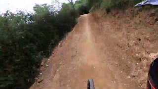
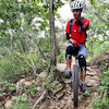
Photos of 4 Riders Bike Park Mountain Bike
trail: Intense
36 |
Nov 6, 2021 @ 11:44am
Nov 6, 2021
trail: Intense
29 |
Nov 6, 2021 @ 11:44am
Nov 6, 2021
trail: Intense
28 |
Nov 6, 2021 @ 11:44am
Nov 6, 2021
trail: Intense
25 |
Nov 6, 2021 @ 11:44am
Nov 6, 2021
trail: Intense
55 |
Nov 6, 2021 @ 11:44am
Nov 6, 2021
trail: Directe a parking
40 |
Nov 6, 2021 @ 10:49am
Nov 6, 2021Videos of 4 Riders Bike Park Mountain Bike

trail: Rumblebikes
2:44 |
362 |
Jun 23, 2020 , Berga
trail: The Wave
2:46 |
278 |
Jun 23, 2020 , Berga
Recent Trail Reports
| status | trail | date | condition | info | user |
|---|---|---|---|---|---|
| Directe a parking | Jun 11, 2022 @ 12:20am Jun 11, 2022 | Dry | xroma | ||
| The Wave | May 15, 2022 @ 1:52am May 15, 2022 | Very Dry | trinyolis | ||
| Rumblebikes | May 15, 2022 @ 1:52am May 15, 2022 | Very Dry | trinyolis | ||
| Intense | May 15, 2022 @ 1:52am May 15, 2022 | Very Dry | trinyolis | ||
| Hard Line | May 14, 2022 @ 1:37am May 14, 2022 | Dry | Xserret |
Activity Feed
| username | action | type | title | date | |
|---|---|---|---|---|---|
 | JulianxBLgJ0 | wishlist | region | 4 Riders Bike Park | Jun 23, 2022 @ 2:05pm Jun 23, 2022 |
| xroma | add | report | Directe a parking | Jun 11, 2022 @ 12:20pm Jun 11, 2022 |
| annacarolxandri | add | route | Circular a Busa | May 22, 2022 @ 10:46pm May 22, 2022 |
 | trinyolis | add | report | The Wave and 2 more | May 18, 2022 @ 7:50am May 18, 2022 |
 | Xserret | add | report | The Wave and 3 more | May 14, 2022 @ 10:38am May 14, 2022 |
Recent Comments
| username | type | title | comment | date | |
|---|---|---|---|---|---|
 | trail | Si hi ha fang (és la pista més humida del... | Nov 6, 2021 @ 10:14am Nov 6, 2021 | ||
 | trail | Pretty nice DH. | Sep 24, 2021 @ 12:21pm Sep 24, 2021 | ||
| trail | El terreny rellisca moltissim només estar un... | Oct 24, 2020 @ 10:36am Oct 24, 2020 |
Nearby Areas
| name | distance | ||||
|---|---|---|---|---|---|
| El Berguedà | 73 | 154 | 2.4 km | ||
| Oristà | 1 | 3 | 16.4 km | ||
| Sallent - Avinyó | 15 | 19 | 17.8 km | ||
| La Molina | 5 | 18 | 18.4 km | ||
| El Serrat de Castellnou | 79 | 28 | 18.5 km |
Bike & Skill Parks
| name | type | city | rating |
|---|---|---|---|
| Mini DH | skill park | Berga |
Activity Type Stats
| activitytype | trails | distance | descent | descent distance | total vertical | rating | global rank | state rank | photos | reports | routes | ridelogs |
|---|---|---|---|---|---|---|---|---|---|---|---|---|
| Mountain Bike | 5 | 3 miles | 2,087 ft | 2 miles | 597 ft | #3,409 | #73 | 7 | 67 | 323 | ||
| E-Bike | 5 | 3 miles | 2,087 ft | 2 miles | 597 ft | #1,259 | #50 | 67 | 10 | |||
| Hike | 1 | 259 ft | 30 ft | 259 ft | 30 ft | 44 | 2 |
- By parlindholm
 & contributors
 - Admins: parlindholm, kardi13
- #37961 - 2,533 views
- 4 riders bike park activity log | embed map of 4 Riders Bike Park mountain bike trails | 4 riders bike park mountain biking points of interest
-
- subscribe
- 3d map
Downloading of trail gps tracks in kml & gpx formats is enabled for 4 Riders Bike Park.
You must login to download files.