close
Trail Conditions
- Unknown
- Snow Groomed
- Snow Packed
- Snow Covered
- Snow Cover Inadequate
- Freeze/thaw Cycle
- Icy
- Prevalent Mud
- Wet
- Variable
- Ideal
- Dry
- Very Dry
Trail Flow (Ridden Direction)
Trailforks scans users ridelogs to determine the most popular direction each trail is ridden. A good flowing trail network will have most trails flowing in a single direction according to their intension.
The colour categories are based on what percentage of riders are riding a trail in its intended direction.
The colour categories are based on what percentage of riders are riding a trail in its intended direction.
- > 96%
- > 90%
- > 80%
- > 70%
- > 50%
- < 50%
- bi-directional trail
- no data
Trail Last Ridden
Trailforks scans ridelogs to determine the last time a trail was ridden.
- < 2 days
- < 1 week
- < 2 weeks
- < 1 month
- < 6 months
- > 6 months
Trail Ridden Direction
The intended direction a trail should be ridden.
- Downhill Only
- Downhill Primary
- Both Directions
- Uphill Primary
- Uphill Only
- One Direction
Contribute Details
Colors indicate trail is missing specified detail.
- Description
- Photos
- Description & Photos
- Videos
Trail Popularity ?
Trailforks scans ridelogs to determine which trails are ridden the most in the last 9 months.
Trails are compared with nearby trails in the same city region with a possible 25 colour shades.
Think of this as a heatmap, more rides = more kinetic energy = warmer colors.
- most popular
- popular
- less popular
- not popular
ATV/ORV/OHV Filter
Max Vehicle Width
inches
Radar Time
x
Activity Recordings
Trailforks users anonymized public ridelogs from the past 6 months.
- mountain biking recent
- mountain biking (>6 month)
- hiking (1 year)
- moto (1 year)
Activity Recordings
Trailforks users anonymized public skilogs from the past 12 months.
- Downhill Ski
- Backcountry Ski
- Nordic Ski
Jump Magnitude Heatmap
Heatmap of where riders jump on trails. Zoom in to see individual jumps, click circles to view jump details.
Trails Deemphasized
Trails are shown in grey.
Only show trails with NO bikes.
Save the current map location and zoom level as your default home location whenever this page is loaded.
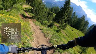
SaveThe Bike Beats - Movimënt Alta Badia Trails is bike park in San Cassiano, Alta Badia. Trails are flow country trails, smooth and fast, suitable for MTB, enduro and E-MTB. The tracks are in beaten earth and sand, for enjoyable and perfect downhill cycling in all weather conditions.
Primary Trail Type: All-Mountain & Downhill
 google parking directions
 Access Info:
Piz Sorega cable car station in San Cassiano, Alta Badia.
Links
Activities Click to view
- Mountain Bike
13 trails
- Hike
6 trails
- Trail Running
6 trails
Bike Park Details
- 1
- 5
- 3
- 1
Region Status
Open as of Jul 3, 2022- Uplift Type
- Gondola
- Season start
- Jun 16
- Season end
- Sep 23
Stats
- Avg Trail Rating
- Trails (view details)
- 11
- Trails Mountain Bike
- 13
- Trails E-Bike
- 8
- Trails Hike
- 6
- Trails Trail Running
- 6
- Total Distance
- 6 miles
- Total Descent
- 3,479 ft
- Total Vertical
- 1,584 ft
- Highest Trailhead
- 6,699 ft
- Reports
- 37
- Ridden Counter
- 1,091
 Articles
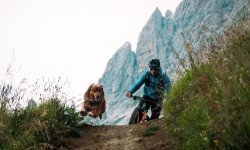
Video: Balu's Back for More Trail Dog Fun in 'Paws & Wheels II'
Nov 9, 2019 from pinkbike.com
A story of how they found each other, and how Balu became an amazing trail dog.
Popular Bike Beats - Movimënt Alta Badia Trails Trails

Recent Trail Reports
| status | trail | date | condition | info | user |
|---|---|---|---|---|---|
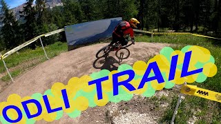
| Ödli | Jul 3, 2022 @ 12:35am Jul 3, 2022 | Ideal | julian-mtb | ||
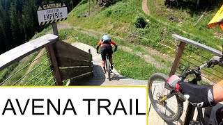
| Avëna | Jul 3, 2022 @ 12:35am Jul 3, 2022 | Ideal | julian-mtb | ||
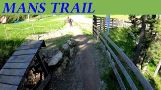
| Mans | Jul 3, 2022 @ 12:35am Jul 3, 2022 | Ideal | julian-mtb | ||
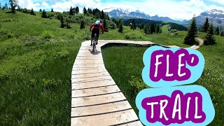
| Flè Trail | Jun 17, 2022 @ 11:28pm Jun 17, 2022 | Ideal | Stained | ||
| Transfer Passo Incisa - Campolongo | Jun 17, 2022 @ 11:28pm Jun 17, 2022 | Variable | Stained | ||
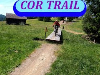
| Cör | Jun 22, 2020 @ 10:52am Jun 22, 2020 | Variable | Slashhie |
Activity Feed
| username | action | type | title | date | |
|---|---|---|---|---|---|
 | cadmortess | ridden | trail | Flè Trail | Jul 5, 2022 @ 10:18am 16 hours |
 | julian-mtb | add | trail | Jump Line and 2 more | Jul 4, 2022 @ 5:43am 2 days |
| julian-mtb | add | report | Ödli and 2 more | Jul 3, 2022 @ 9:09am 3 days |
| julian-mtb | add | trail | Sentiero 23 and 1 more | Jul 3, 2022 @ 3:07am 3 days |
| julian-mtb | add | poi | Parking and 1 more | Jun 30, 2022 @ 1:26am Jun 30, 2022 |
Recent Comments
| username | type | title | comment | date | |
|---|---|---|---|---|---|
 | trail | Noce trail, i cut the last part by taking... | Aug 16, 2021 @ 12:52pm Aug 16, 2021 | ||
| trail | Great track, although not nearly black diamond... | Jun 22, 2020 @ 10:51am Jun 22, 2020 |
Nearby Areas
| name | distance | ||||
|---|---|---|---|---|---|
| Arabba | 2 | 5 | 1 | 6.8 km | |
| Cortina | 1 | 8 | 2 | 1 | 7.9 km |
| Fassa Bike District | 4 | 8 | 4 | 2 | 8 km |
| Penia | 1 | 9.6 km | |||
| Val Fiorentina | 2 | 3 | 2 | 9.7 km |
Activity Type Stats
| activitytype | trails | distance | descent | descent distance | total vertical | rating | global rank | state rank | photos | reports | routes | ridelogs |
|---|---|---|---|---|---|---|---|---|---|---|---|---|
| Mountain Bike | 13 | 6 miles | 3,481 ft | 5 miles | 1,585 ft | #3,589 | #129 | 37 | 467 | |||
| E-Bike | 8 | 2 miles | 538 ft | 5,023 ft | 453 ft | 29 | 34 | |||||
| Hike | 6 | #501 | 29 | 56 | ||||||||
| Trail Running | 6 | #478 | 29 | 1 |
- By zocknroll
 TRAILFORKS TRAILANDIJA & contributors
 - Admins: caval, larry81541
- #25224 - 2,999 views
- bike beats - movimënt alta badia trails activity log | embed map of Bike Beats - Movimënt Alta Badia Trails mountain bike trails | bike beats - movimënt alta badia trails mountain biking points of interest
Downloading of trail gps tracks in kml & gpx formats is enabled for Bike Beats - Movimënt Alta Badia Trails.
You must login to download files.