close
Trail Conditions
- Unknown
- Snow Groomed
- Snow Packed
- Snow Covered
- Snow Cover Inadequate
- Freeze/thaw Cycle
- Icy
- Prevalent Mud
- Wet
- Variable
- Ideal
- Dry
- Very Dry
Trail Flow (Ridden Direction)
Trailforks scans users ridelogs to determine the most popular direction each trail is ridden. A good flowing trail network will have most trails flowing in a single direction according to their intension.
The colour categories are based on what percentage of riders are riding a trail in its intended direction.
The colour categories are based on what percentage of riders are riding a trail in its intended direction.
- > 96%
- > 90%
- > 80%
- > 70%
- > 50%
- < 50%
- bi-directional trail
- no data
Trail Last Ridden
Trailforks scans ridelogs to determine the last time a trail was ridden.
- < 2 days
- < 1 week
- < 2 weeks
- < 1 month
- < 6 months
- > 6 months
Trail Ridden Direction
The intended direction a trail should be ridden.
- Downhill Only
- Downhill Primary
- Both Directions
- Uphill Primary
- Uphill Only
- One Direction
Contribute Details
Colors indicate trail is missing specified detail.
- Description
- Photos
- Description & Photos
- Videos
Trail Popularity ?
Trailforks scans ridelogs to determine which trails are ridden the most in the last 9 months.
Trails are compared with nearby trails in the same city region with a possible 25 colour shades.
Think of this as a heatmap, more rides = more kinetic energy = warmer colors.
- most popular
- popular
- less popular
- not popular
ATV/ORV/OHV Filter
Max Vehicle Width
inches
Radar Time
x
Activity Recordings
Trailforks users anonymized public ridelogs from the past 6 months.
- mountain biking recent
- mountain biking (>6 month)
- hiking (1 year)
- moto (1 year)
Activity Recordings
Trailforks users anonymized public skilogs from the past 12 months.
- Downhill Ski
- Backcountry Ski
- Nordic Ski
Jump Magnitude Heatmap
Heatmap of where riders jump on trails. Zoom in to see individual jumps, click circles to view jump details.
Trails Deemphasized
Trails are shown in grey.
Only show trails with NO bikes.
Save the current map location and zoom level as your default home location whenever this page is loaded.
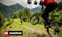
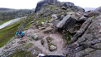
SaveBike Republic Sölden; either take the two gondolas from Sölden up to the trails, pedal uphill or use the local bus system for an uplift; lots of enduro trails from technical to super flowy ("Teäre Line").
Primary Trail Type: All-Mountain & Downhill
eBikes Allowed:
Yes
Shuttleable: YES
AKA: Bike Republic Sölden
Links
This region uses the Uk/Euro style trail grading system.
Activities Click to view
- Mountain Bike
31 trails
- E-Bike
32 trails
- Hike
3 trails
- Trail Running
3 trails
Bike Park Details
- 1
- 10
- 9
- 9
Region Status
Caution as of Jul 5, 2021- Uplift Type
- Gondola
Stats
- Avg Trail Rating
- Trails (view details)
- 32
- Trails Mountain Bike
- 31
- Trails E-Bike
- 32
- Trails Hike
- 3
- Trails Trail Running
- 3
- Total Distance
- 44 miles
- Total Descent
- 32,282 ft
- Total Vertical
- 4,751 ft
- Highest Trailhead
- 9,132 ft
- Reports
- 452
- Photos
- 307
- Ridden Counter
- 10,570
 Articles
Local Flavours: The Complete Guide to Riding in Sölden, Austria
Jul 25, 2019 from pinkbike.com
Everything you need to know about mountain biking in this picturesque mountain village in the Austrian state of Tyrol.
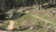
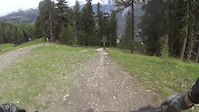
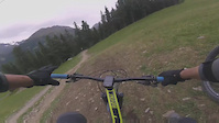
Popular Bike Republic Sölden Mountain Biking Trails
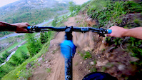
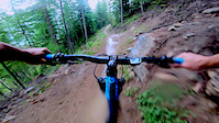
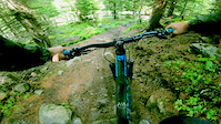
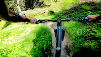
Photos of Bike Republic Sölden Mountain Bike
trail: Ollweite Line
276 |
Jan 1, 2019 @ 8:15am
Jan 1, 2019
trail: Ollweite Line
237 |
Jan 1, 2019 @ 8:14am
Jan 1, 2019
trail: Ollweite Line
135 |
Jul 8, 2018 @ 10:09pm
Jul 8, 2018
trail: Ollweite Line
121 |
Jul 8, 2018 @ 10:09pm
Jul 8, 2018
trail: Nene Trail
220 |
Dec 19, 2017 @ 12:49pm
Dec 19, 2017
trail: Zaahe Line
520 |
Dec 7, 2016 @ 12:17am
Dec 7, 2016
trail: Zaahe Line
153 |
Sep 14, 2016 @ 12:41pm
Sep 14, 2016
trail: Teäre Line
169 |
Jun 15, 2016 @ 11:58pm
Jun 15, 2016Videos of Bike Republic Sölden Mountain Bike
trail: GAHE LINE
81 |
Dec 30, 2021
trail: Teäre Line
116 |
Oct 11, 2021
trail: Teäre Line
21 |
Jul 7, 2021
trail: Ollweite Line
1:00 |
35 |
Apr 13, 2020
trail: Ohn Line
1:00 |
57 |
Apr 13, 2020
trail: Nene Trail
1:00 |
49 |
Apr 13, 2020
trail: Leiterberg Trail
1:00 |
40 |
Apr 13, 2020
trail: Fernar Trail
6:13 |
386 |
Feb 10, 2020
Recent Trail Reports
| status | trail | date | condition | info | user |
|---|---|---|---|---|---|
| Bartig's Bödele Trail | Jul 4, 2022 @ 10:30pm 1 day | Dry | StefanS154 | ||
| Ollweite Line | Jun 19, 2022 @ 7:44am Jun 19, 2022 | Very Dry | Felix1509 | ||
| Olm Volle Line | Jun 17, 2022 @ 9:40pm Jun 17, 2022 | Dry | sebkrysz | ||
| Troaln Line | Jun 17, 2022 @ 12:30pm Jun 17, 2022 | Ideal | Felix1509 | ||
| Rettenbachalm Trail | Jun 17, 2022 @ 12:29pm Jun 17, 2022 | Ideal | Felix1509 | ||
| Gampe Trail | Jun 17, 2022 @ 12:28pm Jun 17, 2022 | Dry | Felix1509 | ||
| Harbe Line | Jun 17, 2022 @ 12:28pm Jun 17, 2022 | Dry | Felix1509 | ||
| Kleble Alm Trail | Jun 15, 2022 @ 5:07am Jun 15, 2022 | Dry | lkristofl | ||
| Ohn Line | Jun 12, 2022 @ 12:28am Jun 12, 2022 | Dry | Talebano | ||
| Nene Trail | Jun 12, 2022 @ 12:28am Jun 12, 2022 | Ideal | Talebano |
Activity Feed
| username | action | type | title | date | |
|---|---|---|---|---|---|
 | tk-w | vote | trail | Zaahe Line | Jul 6, 2022 @ 12:55am 2 hours |
 | cbtp | comment | report | Bartig's Bödele Trail | Jul 5, 2022 @ 12:36am 1 day |
| cbtp | update | trail | Bartig's Bödele Trail | Jul 5, 2022 @ 12:35am 1 day |
 | StefanS154 | add | report | Bartig's Bödele Trail | Jul 4, 2022 @ 10:30pm 1 day |
| StefanS154 | comment | trail | Bartig's Bödele Trail | Jul 4, 2022 @ 10:27pm 1 day |
Recent Comments
| username | type | title | comment | date | |
|---|---|---|---|---|---|
| report | danke für die Info – ist korrigiert! | Jul 5, 2022 @ 12:36am 1 day | ||
| trail | MTB / Hike erlaubt | Jul 4, 2022 @ 10:27pm 1 day | ||
| trail | Great views but such a boring trail. This... | Sep 13, 2021 @ 8:34am Sep 13, 2021 | ||
| trail | This is the most “trail” trail in the... | Sep 13, 2021 @ 8:33am Sep 13, 2021 | ||
| trail | This trail was underwhelming. Needs way more... | Sep 13, 2021 @ 8:31am Sep 13, 2021 |
Nearby Areas
| name | distance | ||||
|---|---|---|---|---|---|
| Pitztal | 12.6 km | ||||
| Trailcenter Ötztaler Höhe | 3 | 19.5 km | |||
| Bikepark Serfaus-Fiss-Ladis | 1 | 6 | 20 km | ||
| Burggrafenamt | 3 | 6 | 21 km | ||
| Bikepark Tirol | 1 | 1 | 22.4 km |
Local Badges
-

Completionist0 awarded
Bike & Skill Parks
| name | type | city | rating |
|---|---|---|---|
| Pumptrack Hotel Sunny Sölden | skill park | Sölden | |
| Pumptrack Rolling Sölden | skill park | Sölden |
Pinkbike Articles
Jul 25, 2019
 Local Flavours: The Complete Guide to Riding in Sölden, Austria
Everything you need to know about mountain biking in this picturesque mountain village in the Austrian state of Tyrol.
Jun 30, 2022
 Vote Now for Deep Summer Wild Card Photographer
It's time to vote for your selection for the wildcard photographer to join the photographers of the Deep Summer Photo Challenge for 2022.
Dec 18, 2019
 Bad Kleinkirchheim & Bikepark Pohorje to be Added to Gravity Card for 2020 Season
21 bike parks make up the Gravity Card offering in 2020.
Activity Type Stats
| activitytype | trails | distance | descent | descent distance | total vertical | rating | global rank | state rank | photos | reports | routes | ridelogs |
|---|---|---|---|---|---|---|---|---|---|---|---|---|
| Mountain Bike | 31 | 42 miles | 30,384 ft | 32 miles | 4,751 ft | #396 | #1 | 307 | 452 | 4,038 | ||
| E-Bike | 32 | 44 miles | 32,283 ft | 34 miles | 4,751 ft | #114 | #1 | 406 | 104 | |||
| Hike | 3 | 4 miles | 3,442 ft | 3 miles | 3,291 ft | #5,772 | #13 | 382 | 72 | |||
| Trail Running | 3 | 4 miles | 3,442 ft | 3 miles | 3,291 ft | #5,784 | #13 | 382 | 5 |
- By lines
 TRAILFORKS & contributors
 - Admins: MTBInnsbruck
- #14363 - 11,988 views
- bike republic sölden activity log | embed map of Bike Republic Sölden mountain bike trails |
Downloading of trail gps tracks in kml & gpx formats is enabled for Bike Republic Sölden.
You must login to download files.