close
Trail Conditions
- Unknown
- Snow Groomed
- Snow Packed
- Snow Covered
- Snow Cover Inadequate
- Freeze/thaw Cycle
- Icy
- Prevalent Mud
- Wet
- Variable
- Ideal
- Dry
- Very Dry
Trail Flow (Ridden Direction)
Trailforks scans users ridelogs to determine the most popular direction each trail is ridden. A good flowing trail network will have most trails flowing in a single direction according to their intension.
The colour categories are based on what percentage of riders are riding a trail in its intended direction.
The colour categories are based on what percentage of riders are riding a trail in its intended direction.
- > 96%
- > 90%
- > 80%
- > 70%
- > 50%
- < 50%
- bi-directional trail
- no data
Trail Last Ridden
Trailforks scans ridelogs to determine the last time a trail was ridden.
- < 2 days
- < 1 week
- < 2 weeks
- < 1 month
- < 6 months
- > 6 months
Trail Ridden Direction
The intended direction a trail should be ridden.
- Downhill Only
- Downhill Primary
- Both Directions
- Uphill Primary
- Uphill Only
- One Direction
Contribute Details
Colors indicate trail is missing specified detail.
- Description
- Photos
- Description & Photos
- Videos
Trail Popularity ?
Trailforks scans ridelogs to determine which trails are ridden the most in the last 9 months.
Trails are compared with nearby trails in the same city region with a possible 25 colour shades.
Think of this as a heatmap, more rides = more kinetic energy = warmer colors.
- most popular
- popular
- less popular
- not popular
ATV/ORV/OHV Filter
Max Vehicle Width
inches
Radar Time
x
Activity Recordings
Trailforks users anonymized public ridelogs from the past 6 months.
- mountain biking recent
- mountain biking (>6 month)
- hiking (1 year)
- moto (1 year)
Activity Recordings
Trailforks users anonymized public skilogs from the past 12 months.
- Downhill Ski
- Backcountry Ski
- Nordic Ski
Jump Magnitude Heatmap
Heatmap of where riders jump on trails. Zoom in to see individual jumps, click circles to view jump details.
Trails Deemphasized
Trails are shown in grey.
Only show trails with NO bikes.
Save the current map location and zoom level as your default home location whenever this page is loaded.
Save
No description for Bikepark Attendorn has been added yet!
Login or register to submit one.
Primary Trail Type: All-Mountain & Downhill
Land Status: City Managed
Activities Click to view
- Mountain Bike
1 trails
- E-Bike
0 trails
- Dirtbike/Moto
1 trails
Bike Park Details
- 1
Region Status
Closed as of Aug 21, 2021Stats
- Trails (view details)
- 1
- Trails Mountain Bike
- 1
- Trails Dirtbike/Moto
- 1
- Total Distance
- 1,050 ft
- Total Descent Distance
- 1,050 ft
- Total Descent
- 122 ft
- Total Vertical
- 124 ft
- Highest Trailhead
- 1,271 ft
- Reports
- 2
- Photos
- 1
- Ridden Counter
- 5
Popular Bikepark Attendorn Mountain Biking Trails
| status | title | difficulty | rating |
|---|---|---|---|
| Single Trail |
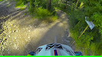
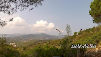
Photos of Bikepark Attendorn Mountain Bike
trail: Single Trail
502 | | 1 comments
Jun 27, 2008 @ 4:38am
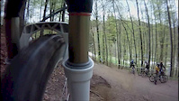
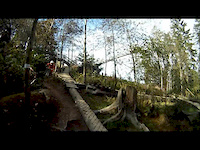
Jun 27, 2008Videos of Bikepark Attendorn Mountain Bike
trail: Single Trail
1:23 |
84 |
Jul 27, 2015
trail: Single Trail
4:56 |
177 |
May 19, 2013
trail: Single Trail
2:25 |
248 |
Oct 12, 2012
trail: Single Trail
2:59 |
164 |
Sep 24, 2012

trail: Single Trail
5:21 |
177 |
Jun 9, 2011

trail: Single Trail
4:47 |
146 |
May 9, 2011
Recent Trail Reports
| status | trail | date | condition | info | user |
|---|---|---|---|---|---|
| Single Trail | Aug 21, 2021 @ 5:55am Aug 21, 2021 | Unknown | nickokio |
Activity Feed
| username | action | type | title | date | |
|---|---|---|---|---|---|
 | nickokio | add | report | Single Trail | Aug 21, 2021 @ 5:55am Aug 21, 2021 |
| Thanefurrows | add | trail | Single Trail | Jun 16, 2020 @ 3:35am Jun 16, 2020 |
Nearby Areas
| name | distance | ||||
|---|---|---|---|---|---|
| bikeparkOE | 3 | 1 | 4.6 km | ||
| Alt Arnsberg Mountains | 4 | 5 | 1 | 19.1 km | |
| Eisenwald | 2 | 19.2 km | |||
| Syburg Trails | 2 | 1 | 2 | 27.8 km | |
| Dortmunder Süden | 12 | 7 | 3 | 29.5 km |
Activity Type Stats
| activitytype | trails | distance | descent | descent distance | total vertical | rating | global rank | state rank | photos | reports | routes | ridelogs |
|---|---|---|---|---|---|---|---|---|---|---|---|---|
| Mountain Bike | 1 | 1,050 ft | 121 ft | 1,050 ft | 125 ft | #11,641 | #172 | 1 | 2 | 22 | ||
| Dirtbike/Moto | 1 | 1,050 ft | 121 ft | 1,050 ft | 125 ft | #284 | #2 | 1 |
- By Thanefurrows & contributors
- Admins: apply
- #38787 - 888 views
- bikepark attendorn activity log | embed map of Bikepark Attendorn mountain bike trails |
-
- subscribe
- 3d map
Downloading of trail gps tracks in kml & gpx formats is enabled for Bikepark Attendorn.
You must login to download files.