close
Trail Conditions
- Unknown
- Snow Groomed
- Snow Packed
- Snow Covered
- Snow Cover Inadequate
- Freeze/thaw Cycle
- Icy
- Prevalent Mud
- Wet
- Variable
- Ideal
- Dry
- Very Dry
Trail Flow (Ridden Direction)
Trailforks scans users ridelogs to determine the most popular direction each trail is ridden. A good flowing trail network will have most trails flowing in a single direction according to their intension.
The colour categories are based on what percentage of riders are riding a trail in its intended direction.
The colour categories are based on what percentage of riders are riding a trail in its intended direction.
- > 96%
- > 90%
- > 80%
- > 70%
- > 50%
- < 50%
- bi-directional trail
- no data
Trail Last Ridden
Trailforks scans ridelogs to determine the last time a trail was ridden.
- < 2 days
- < 1 week
- < 2 weeks
- < 1 month
- < 6 months
- > 6 months
Trail Ridden Direction
The intended direction a trail should be ridden.
- Downhill Only
- Downhill Primary
- Both Directions
- Uphill Primary
- Uphill Only
- One Direction
Contribute Details
Colors indicate trail is missing specified detail.
- Description
- Photos
- Description & Photos
- Videos
Trail Popularity ?
Trailforks scans ridelogs to determine which trails are ridden the most in the last 9 months.
Trails are compared with nearby trails in the same city region with a possible 25 colour shades.
Think of this as a heatmap, more rides = more kinetic energy = warmer colors.
- most popular
- popular
- less popular
- not popular
ATV/ORV/OHV Filter
Max Vehicle Width
inches
Radar Time
x
Activity Recordings
Trailforks users anonymized public ridelogs from the past 6 months.
- mountain biking recent
- mountain biking (>6 month)
- hiking (1 year)
- moto (1 year)
Activity Recordings
Trailforks users anonymized public skilogs from the past 12 months.
- Downhill Ski
- Backcountry Ski
- Nordic Ski
Jump Magnitude Heatmap
Heatmap of where riders jump on trails. Zoom in to see individual jumps, click circles to view jump details.
Trails Deemphasized
Trails are shown in grey.
Only show trails with NO bikes.
Save the current map location and zoom level as your default home location whenever this page is loaded.
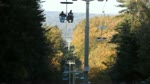
SaveThe trails are free of charge. Chairlift is available; the cost is 3 rides for 7 Euros, single lift option also available.
During summer the chairlift operates Tuesday - Sunday.
During summer the chairlift operates Tuesday - Sunday.
source: Bikepark Koliba
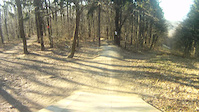
Primary Trail Type: All-Mountain & Downhill
eBikes Allowed:
Yes
Land Status: Managed by Local Riding Association
 google parking directions
Links
Activities Click to view
- Mountain Bike
4 trails
- E-Bike
0 trails
Bike Park Details
- 1
- 2
- 1
Region Status
Caution as of Feb 3, 2020- Day Ticket
- 7 EUR
- Uplift Type
- Chair Lift
- Season start
- Mar 1
- Season end
- Dec 1
Stats
- Avg Trail Rating
- Trails (view details)
- 4
- Trails Mountain Bike
- 4
- Total Distance
- 3 miles
- Total Descent
- 2,380 ft
- Total Vertical
- 580 ft
- Highest Trailhead
- 1,392 ft
- Reports
- 175
- Photos
- 90
- Ridden Counter
- 731
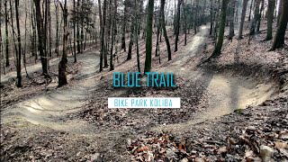
Popular Bikepark Koliba Mountain Biking Trails
| status | title | difficulty | rating |
|---|---|---|---|
| Blue Trail | |||
| Driver8 | |||
| Rohatka | |||
| Kameňák |
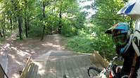
Photos of Bikepark Koliba Mountain Bike
trail: Driver8
25 |
Mar 4, 2022 @ 2:04am
Mar 4, 2022
trail: Rohatka
139 |
Nov 5, 2017 @ 1:54pm
Nov 5, 2017
trail: Blue Trail
200 |
Jul 1, 2017 @ 2:17pm
Jul 1, 2017
trail: Rohatka
125 |
Jun 15, 2017 @ 9:07am
Jun 15, 2017
trail: Driver8
426 |
Aug 15, 2016 @ 1:15am
Aug 15, 2016
trail: Rohatka
530 |
Aug 14, 2016 @ 2:33am
Aug 14, 2016
trail: Driver8
287 |
Jun 9, 2016 @ 5:07am
Jun 9, 2016
trail: Rohatka
351 |
Apr 29, 2015 @ 2:57pm
Apr 29, 2015Videos of Bikepark Koliba Mountain Bike

trail: Kameňák
158 |
Dec 3, 2020
trail: Rohatka
3:51 |
1121 |
May 14, 2012
trail: Rohatka
4:00 |
549 |
Mar 25, 2012
trail: Rohatka
3:14 |
206 |
Oct 9, 2010
trail: Blue Trail
8:54 |
31 |
Jun 15, 2022 , Bratislava
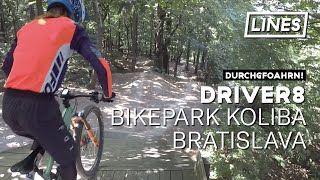
trail: Driver8
3:04 |
176 |
Jun 30, 2021 , Bratislava
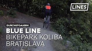
trail: Blue Trail
3:46 |
158 |
Jun 30, 2021 , Bratislava
trail: Driver8
2:46 |
238 |
Apr 12, 2021 , Bratislava
Recent Trail Reports
no previous reports, add one now!
Activity Feed
| username | action | type | title | date | |
|---|---|---|---|---|---|
 | C3llarioSK | add | report | Driver8 | Jun 18, 2022 @ 7:27am Jun 18, 2022 |
 | andykiro | add | video | MTB Blue Trail / Koliba / Tip na cyklo / Bike park Malé Karapty / Singletrail / GoPro... | Jun 15, 2022 @ 3:17pm Jun 15, 2022 |
| HollyBoni | add | report | Kameňák | Jun 15, 2022 @ 12:25am Jun 15, 2022 |
 | hluchotechna | add | report | Rohatka | May 21, 2022 @ 11:54am May 21, 2022 |
| miskolci | add | report | Blue Trail | May 10, 2022 @ 12:14am May 10, 2022 |
Recent Comments
| username | type | title | comment | date | |
|---|---|---|---|---|---|
| trail | Výborný flow trail aj pre menej... | Mar 4, 2022 @ 11:49am Mar 4, 2022 | ||
| trail | Dobrý trail pre začiatočníkov alebo na... | Mar 4, 2022 @ 2:06am Mar 4, 2022 | ||
| trail | Je to fajn ale málo udržiavané | Dec 21, 2021 @ 6:00am Dec 21, 2021 | ||
| trail | netuším kde je nejaký trail je to proste... | Dec 21, 2021 @ 5:59am Dec 21, 2021 | ||
| trail | neudržiavané..inak fajn | Nov 16, 2021 @ 12:18pm Nov 16, 2021 |
Nearby Areas
| name | distance | ||||
|---|---|---|---|---|---|
| Bratislavský lesopark | 23 | 5 | 3 | 3.2 km | |
| Devínska Kobyla | 1 | 3.8 km | |||
| Trail Biely Kríž | 4 | 2 | 2 | 4 km | |
| Pajštún | 1 | 2 | 6.3 km | ||
| Lozorno | 1 | 6 | 1 | 9.2 km |
- By Juraj SBOZ & contributors
- Admins: SBOZ
- #7681 - 6,839 views
- bikepark koliba activity log | embed map of Bikepark Koliba mountain bike trails | bikepark koliba mountain biking points of interest
-
- subscribe
- 3d map
Downloading of trail gps tracks in kml & gpx formats is enabled for Bikepark Koliba.
You must login to download files.