close
Trail Conditions
- Unknown
- Snow Groomed
- Snow Packed
- Snow Covered
- Snow Cover Inadequate
- Freeze/thaw Cycle
- Icy
- Prevalent Mud
- Wet
- Variable
- Ideal
- Dry
- Very Dry
Trail Flow (Ridden Direction)
Trailforks scans users ridelogs to determine the most popular direction each trail is ridden. A good flowing trail network will have most trails flowing in a single direction according to their intension.
The colour categories are based on what percentage of riders are riding a trail in its intended direction.
The colour categories are based on what percentage of riders are riding a trail in its intended direction.
- > 96%
- > 90%
- > 80%
- > 70%
- > 50%
- < 50%
- bi-directional trail
- no data
Trail Last Ridden
Trailforks scans ridelogs to determine the last time a trail was ridden.
- < 2 days
- < 1 week
- < 2 weeks
- < 1 month
- < 6 months
- > 6 months
Trail Ridden Direction
The intended direction a trail should be ridden.
- Downhill Only
- Downhill Primary
- Both Directions
- Uphill Primary
- Uphill Only
- One Direction
Contribute Details
Colors indicate trail is missing specified detail.
- Description
- Photos
- Description & Photos
- Videos
Trail Popularity ?
Trailforks scans ridelogs to determine which trails are ridden the most in the last 9 months.
Trails are compared with nearby trails in the same city region with a possible 25 colour shades.
Think of this as a heatmap, more rides = more kinetic energy = warmer colors.
- most popular
- popular
- less popular
- not popular
ATV/ORV/OHV Filter
Max Vehicle Width
inches
Radar Time
x
Activity Recordings
Trailforks users anonymized public ridelogs from the past 6 months.
- mountain biking recent
- mountain biking (>6 month)
- hiking (1 year)
- moto (1 year)
Activity Recordings
Trailforks users anonymized public skilogs from the past 12 months.
- Downhill Ski
- Backcountry Ski
- Nordic Ski
Jump Magnitude Heatmap
Heatmap of where riders jump on trails. Zoom in to see individual jumps, click circles to view jump details.
Trails Deemphasized
Trails are shown in grey.
Only show trails with NO bikes.
Save the current map location and zoom level as your default home location whenever this page is loaded.
SaveOur Bike Park is small but nice.
We offer a main exit, which is supplemented by various singletrack and North Shore-elements. The main route is easy to drive and also suitable for beginners and children.
With many curves, tables, wall rides and wave the route swings to the valley.
Also rounders provides the route a lot of fun, especially since the more demanding obstacles can be specifically controlled.
With us you will find one of the most well-kept trails.
Over 200 kms of bike paths in the area
The Mountain Bike Park Samer offers free riders and cross-country riders unlimited fun.
source: Bikepark Samerberg
Activities Click to view
- Mountain Bike
6 trails
- E-Bike
3 trails
- Hike
3 trails
- Trail Running
3 trails
Bike Park Details
- 1
- 1
- 4
Region Status
Open as of Jun 5, 2022- Day Ticket
- 13 EUR
- Uplift Type
- Chair Lift
Stats
- Avg Trail Rating
- Trails (view details)
- 6
- Trails Mountain Bike
- 6
- Trails E-Bike
- 3
- Trails Hike
- 3
- Trails Trail Running
- 3
- Total Distance
- 4 miles
- Total Descent
- 2,131 ft
- Total Vertical
- 1,944 ft
- Highest Trailhead
- 4,280 ft
- Reports
- 30
- Photos
- 14
- Ridden Counter
- 423
Popular Bikepark Samerberg Mountain Biking Trails
Bikepark Samerberg Mountain Bike Routes
| title | rating | distance |
|---|---|---|
| Hochries mit Mili-Trail | 18 miles |
Photos of Bikepark Samerberg Mountain Bike
trail: Bikepark Samerberg Blue Line
206 |
Dec 8, 2020 @ 2:19pm
Dec 8, 2020
trail: Bikepark Samerberg Blue Line
102 |
Dec 5, 2020 @ 12:15pm
Dec 5, 2020
trail: Angry Lady Upper
159 |
Sep 23, 2020 @ 12:38pm
Sep 23, 2020
trail: Angry Lady Upper
166 |
Sep 23, 2020 @ 12:35pm
Sep 23, 2020
trail: Angry Lady Upper
147 |
Sep 23, 2020 @ 12:34pm
Sep 23, 2020
trail: Angry Lady Upper
153 |
Sep 23, 2020 @ 12:34pm
Sep 23, 2020
trail: Angry Lady Upper
161 |
Sep 23, 2020 @ 12:34pm
Sep 23, 2020
trail: Angry Lady Upper
134 |
Sep 23, 2020 @ 12:34pm
Sep 23, 2020Videos of Bikepark Samerberg Mountain Bike
youtuber
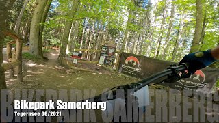
![Bikepark Samerberg 2021 - Tegernsee - MTB-Trails]()
trail: Bikepark Samerberg Blue Line
5:29 |
164 |
Jul 24, 2021 , Samerberg
trail: Bikepark Samerberg Blue Line
14:23 |
91 |
Jun 24, 2021 , Samerberg
youtuber
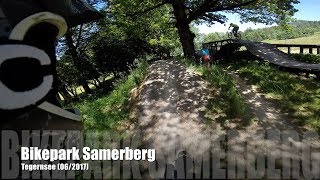
![Bikepark Samerberg 2017 - Tegernsee - MTB-Trails]()
trail: Bikepark Samerberg Blue Line
5:11 |
289 |
May 27, 2020 , Samerberg
youtuber
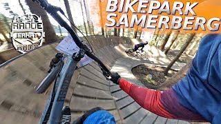
![BIKEPARK SAMERBERG 2019 Trail check with Raddiesl]()
10:48 |
266 |
May 29, 2019
Recent Trail Reports
| status | trail | date | condition | info | user |
|---|---|---|---|---|---|
| Bikepark Samerberg Blue Line | Jun 18, 2022 @ 8:00am Jun 18, 2022 | Ideal | Nullumnihil | ||
| Angry Lady Lower | Jun 5, 2022 @ 12:42am Jun 5, 2022 | Variable | Uweauge | ||
| Uphill Bikepark Samerberg | Mar 27, 2022 @ 2:51am Mar 27, 2022 | Ideal | Clod86 | ||
| Am Pöppl - pasiboo | Dec 5, 2021 @ 2:40am Dec 5, 2021 | Snow Packed | dserke | ||
| Angry Lady Upper | Oct 31, 2020 @ 4:11am Oct 31, 2020 | Variable | 3cBc | ||
| Seitenalmen | Jan 11, 2020 @ 11:59pm Jan 11, 2020 | Snow Packed | andi-frede |
Activity Feed
| username | action | type | title | date | |
|---|---|---|---|---|---|
 | Nullumnihil | add | report | Bikepark Samerberg Blue Line | Jun 18, 2022 @ 8:00am Jun 18, 2022 |
| Aleximus | wishlist | region | Bikepark Samerberg | Jun 10, 2022 @ 1:08pm Jun 10, 2022 |
| Silkeverena | wishlist | trail | Angry Lady Upper | Jun 8, 2022 @ 2:57pm Jun 8, 2022 |
| Uweauge | add | report | Angry Lady Lower | Jun 5, 2022 @ 9:32am Jun 5, 2022 |
| jvloeben | ridden | trail | Angry Lady Upper | Apr 24, 2022 @ 7:12am Apr 24, 2022 |
Recent Comments
| username | type | title | comment | date | |
|---|---|---|---|---|---|
| trail | Great start but then gets super tough. Steep... | Apr 24, 2021 @ 12:34pm Apr 24, 2021 | ||
| trail | Angry ladies (hikers) in the trail ???? | Sep 15, 2020 @ 1:06pm Sep 15, 2020 | ||
 | trail | There are some harder sections, in its first... | Sep 13, 2020 @ 7:04am Sep 13, 2020 |
Nearby Areas
| name | distance | ||||
|---|---|---|---|---|---|
| Samerberg | 1 | 2 | 3 | 2 | 1.7 km |
| Kampenwand | 5 | 10 | 5 | 6.2 km | |
| Mangfalltal | 11.8 km | ||||
| Berchtesgadener Land | 12 | 14 | 6 | 5 | 14.7 km |
| Schliersee Spitzingsee Bayrischzell Area | 11 | 13 | 5 | 4 | 14.7 km |
Activity Type Stats
| activitytype | trails | distance | descent | descent distance | total vertical | rating | global rank | state rank | photos | reports | routes | ridelogs |
|---|---|---|---|---|---|---|---|---|---|---|---|---|
| Mountain Bike | 6 | 4 miles | 2,133 ft | 3 miles | 1,946 ft | #4,559 | #82 | 14 | 30 | 1 | 922 | |
| E-Bike | 3 | 2 miles | 745 ft | 1 mile | 656 ft | #2,217 | #66 | 26 | 40 | |||
| Hike | 3 | 2 miles | 505 ft | 4,665 ft | 650 ft | #10,586 | #125 | 25 | 49 | |||
| Trail Running | 3 | 2 miles | 505 ft | 4,665 ft | 650 ft | #10,526 | #125 | 25 | 1 |
- By brenthillier
 NSMBA TRAILFORKS & contributors
 - Admins: apply
- #6160 - 5,918 views
- bikepark samerberg activity log | embed map of Bikepark Samerberg mountain bike trails |
-
- subscribe
- 3d map
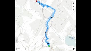
Downloading of trail gps tracks in kml & gpx formats is enabled for Bikepark Samerberg.
You must login to download files.