close
Trail Conditions
- Unknown
- Snow Groomed
- Snow Packed
- Snow Covered
- Snow Cover Inadequate
- Freeze/thaw Cycle
- Icy
- Prevalent Mud
- Wet
- Variable
- Ideal
- Dry
- Very Dry
Trail Flow (Ridden Direction)
Trailforks scans users ridelogs to determine the most popular direction each trail is ridden. A good flowing trail network will have most trails flowing in a single direction according to their intension.
The colour categories are based on what percentage of riders are riding a trail in its intended direction.
The colour categories are based on what percentage of riders are riding a trail in its intended direction.
- > 96%
- > 90%
- > 80%
- > 70%
- > 50%
- < 50%
- bi-directional trail
- no data
Trail Last Ridden
Trailforks scans ridelogs to determine the last time a trail was ridden.
- < 2 days
- < 1 week
- < 2 weeks
- < 1 month
- < 6 months
- > 6 months
Trail Ridden Direction
The intended direction a trail should be ridden.
- Downhill Only
- Downhill Primary
- Both Directions
- Uphill Primary
- Uphill Only
- One Direction
Contribute Details
Colors indicate trail is missing specified detail.
- Description
- Photos
- Description & Photos
- Videos
Trail Popularity ?
Trailforks scans ridelogs to determine which trails are ridden the most in the last 9 months.
Trails are compared with nearby trails in the same city region with a possible 25 colour shades.
Think of this as a heatmap, more rides = more kinetic energy = warmer colors.
- most popular
- popular
- less popular
- not popular
ATV/ORV/OHV Filter
Max Vehicle Width
inches
Radar Time
x
Activity Recordings
Trailforks users anonymized public ridelogs from the past 6 months.
- mountain biking recent
- mountain biking (>6 month)
- hiking (1 year)
- moto (1 year)
Activity Recordings
Trailforks users anonymized public skilogs from the past 12 months.
- Downhill Ski
- Backcountry Ski
- Nordic Ski
Jump Magnitude Heatmap
Heatmap of where riders jump on trails. Zoom in to see individual jumps, click circles to view jump details.
Trails Deemphasized
Trails are shown in grey.
Only show trails with NO bikes.
Save the current map location and zoom level as your default home location whenever this page is loaded.
SaveKostenloser Bikepark ohne Lift/Shuttle. Wird gerne als Dirtjump-Line für Fullies bezeichnet.
Ganzjährig geöffnet, außer bei Nässe.
Ganzjährig geöffnet, außer bei Nässe.
Primary Trail Type: All-Mountain & Downhill
Links
Activities Click to view
- Mountain Bike
2 trails
- Hike
0 trails
- Trail Running
0 trails
Bike Park Details
- 2
Region Status
Closed as of Dec 19, 2019Stats
- Avg Trail Rating
- Trails (view details)
- 2
- Trails Mountain Bike
- 2
- Trails E-Bike
- 2
- Total Distance
- 1,459 ft
- Total Descent
- 33 ft
- Total Vertical
- 21 ft
- Highest Trailhead
- 1,370 ft
- Reports
- 2
- Photos
- 5
- Ridden Counter
- 44
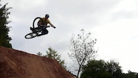
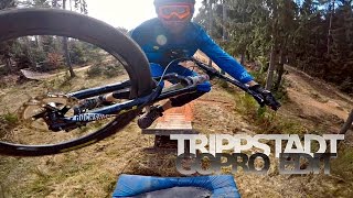
Popular Bikepark Trippstadt Mountain Biking Trails
| status | title | difficulty | rating |
|---|---|---|---|
| Hauptline | |||
| Flow line 1 |
Photos of Bikepark Trippstadt Mountain Bike
Videos of Bikepark Trippstadt Mountain Bike
trail: Flow line 1
0:44 |
491 |
Nov 19, 2014
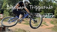
trail: Hauptline
1:01 |
239 |
Aug 23, 2013
Recent Trail Reports
| status | trail | date | condition | info | user |
|---|---|---|---|---|---|
| Flow line 1 | Dec 19, 2019 @ 11:20pm Dec 19, 2019 | Snow Covered | kyleluvsdh | ||
| Hauptline | Dec 19, 2019 @ 11:20pm Dec 19, 2019 | Snow Covered | kyleluvsdh |
Activity Feed
| username | action | type | title | date | |
|---|---|---|---|---|---|
 | mtbnikklas | add | photo | in Rammelsbach, Germany and 1 more | Sep 13, 2021 @ 3:14pm Sep 13, 2021 |
 | sven147 | vote | trail | Flow line 1 and 1 more | Jun 26, 2021 @ 11:44am Jun 26, 2021 |
| Schocho89 | ridden | trail | Hauptline | Nov 6, 2020 @ 11:32am Nov 6, 2020 |
| TeddyTheGreat | wishlist | trail | Hauptline | Jan 4, 2020 @ 4:51am Jan 4, 2020 |
 | kyleluvsdh | add | report | Flow line 1 and 1 more | Dec 19, 2019 @ 11:20pm Dec 19, 2019 |
Nearby Areas
| name | distance | ||||
|---|---|---|---|---|---|
| Kalmit | 9 | 16 | 7 | 15 km | |
| Weinbiet | 2 | 8 | 16 km | ||
| Stabenberg | 2 | 4 | 1 | 16.8 km | |
| Eckkopf | 6 | 13 | 1 | 17.1 km | |
| Donnersberg | 10 | 18.5 km |
Activity Type Stats
| activitytype | trails | distance | descent | descent distance | total vertical | rating | global rank | state rank | photos | reports | routes | ridelogs |
|---|---|---|---|---|---|---|---|---|---|---|---|---|
| Mountain Bike | 2 | 1,460 ft | 33 ft | 1,001 ft | 23 ft | #3,619 | #55 | 5 | 2 | 69 | ||
| E-Bike | 2 | 1,460 ft | 33 ft | 1,001 ft | 23 ft | 5 |
- By sp00n82
 HDRiders & contributors
 - Admins: apply
- #26485 - 1,479 views
- bikepark trippstadt activity log | embed map of Bikepark Trippstadt mountain bike trails |
Downloading of trail gps tracks in kml & gpx formats is enabled for Bikepark Trippstadt.
You must login to download files.