close
Trail Conditions
- Unknown
- Snow Groomed
- Snow Packed
- Snow Covered
- Snow Cover Inadequate
- Freeze/thaw Cycle
- Icy
- Prevalent Mud
- Wet
- Variable
- Ideal
- Dry
- Very Dry
Trail Flow (Ridden Direction)
Trailforks scans users ridelogs to determine the most popular direction each trail is ridden. A good flowing trail network will have most trails flowing in a single direction according to their intension.
The colour categories are based on what percentage of riders are riding a trail in its intended direction.
The colour categories are based on what percentage of riders are riding a trail in its intended direction.
- > 96%
- > 90%
- > 80%
- > 70%
- > 50%
- < 50%
- bi-directional trail
- no data
Trail Last Ridden
Trailforks scans ridelogs to determine the last time a trail was ridden.
- < 2 days
- < 1 week
- < 2 weeks
- < 1 month
- < 6 months
- > 6 months
Trail Ridden Direction
The intended direction a trail should be ridden.
- Downhill Only
- Downhill Primary
- Both Directions
- Uphill Primary
- Uphill Only
- One Direction
Contribute Details
Colors indicate trail is missing specified detail.
- Description
- Photos
- Description & Photos
- Videos
Trail Popularity ?
Trailforks scans ridelogs to determine which trails are ridden the most in the last 9 months.
Trails are compared with nearby trails in the same city region with a possible 25 colour shades.
Think of this as a heatmap, more rides = more kinetic energy = warmer colors.
- most popular
- popular
- less popular
- not popular
ATV/ORV/OHV Filter
Max Vehicle Width
inches
Radar Time
x
Activity Recordings
Trailforks users anonymized public ridelogs from the past 6 months.
- mountain biking recent
- mountain biking (>6 month)
- hiking (1 year)
- moto (1 year)
Activity Recordings
Trailforks users anonymized public skilogs from the past 12 months.
- Downhill Ski
- Backcountry Ski
- Nordic Ski
Jump Magnitude Heatmap
Heatmap of where riders jump on trails. Zoom in to see individual jumps, click circles to view jump details.
Trails Deemphasized
Trails are shown in grey.
Only show trails with NO bikes.
Save the current map location and zoom level as your default home location whenever this page is loaded.
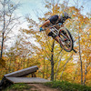
SaveBoler Mountain has 120 acres of property, which offers some of the best cross country terrain in Ontario.
We offer a Beginner loop and an advanced loop. We have been host to many local, provincial and national events including Canada Cups, Canada Summer Games, Ontario Cups, Points races and Citizens races.
We offer a Beginner loop and an advanced loop. We have been host to many local, provincial and national events including Canada Cups, Canada Summer Games, Ontario Cups, Points races and Citizens races.
source: Boler Mountain Page
Primary Trail Type: Cross-Country
Shuttleable: YES
Land Status: Ski Resort
Activities Click to view
- Mountain Bike
31 trails
- Hike
0 trails
- Trail Running
0 trails
- Downhill Ski
15 trails
Region Details
- 9
- 15
- 7
Region Status
Open as of May 30, 2022- Day Ticket
- $8.85 CAD
Stats
- Avg Trail Rating
- Trails (view details)
- 46
- Trails Mountain Bike
- 31
- Trails Downhill Ski
- 15
- Total Distance
- 7 miles
- Total Descent
- 1,946 ft
- Total Vertical
- 194 ft
- Highest Trailhead
- 1,054 ft
- Reports
- 700
- Photos
- 57
- Ridden Counter
- 4,271
Popular Boler Mountain Mountain Biking Trails
Boler Mountain Mountain Bike Routes
| title | rating | distance |
|---|---|---|
| Boler 11KM | 7 miles | |
| Boler Mountain - Black Trail | 3 miles | |
| Boler Mountain - Red Trail | 3 miles | |
| Boler Mountain - Yellow Trail | 2 miles |
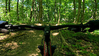
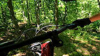
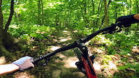
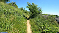
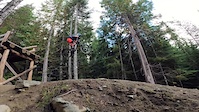
Photos of Boler Mountain Mountain Bike
trail: Breaktime
83 |
Nov 24, 2021 @ 7:35pm
Nov 24, 2021
trail: Heart Attack Hill
87 |
Jul 9, 2021 @ 5:37pm
Jul 9, 2021
trail: The Orchard
95 |
Jun 6, 2021 @ 8:12am
Jun 6, 2021
trail: Pull the Chute
78 |
May 15, 2021 @ 7:04pm
May 15, 2021
trail: 21st Century Flow
85 |
May 15, 2021 @ 7:03pm
May 15, 2021
trail: Breaktime
110 |
May 15, 2021 @ 7:00pm
May 15, 2021
trail: Rolling Pines
131 |
Apr 18, 2021 @ 6:13pm
Apr 18, 2021
trail: Rolling Pines
79 |
Apr 18, 2021 @ 6:13pm
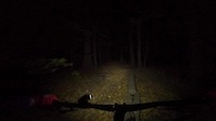
Apr 18, 2021Videos of Boler Mountain Mountain Bike
trail: The Turns
7 |
Jun 22, 2022
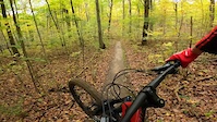
trail: Washboard
17 |
Jun 21, 2022
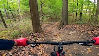
trail: Berm Alley
13 |
Jun 20, 2022
trail: 21st Century Flow
16 |
Jun 19, 2022
trail: Up Past the Skunk House
107 |
Nov 25, 2021
trail: GM Corners
20 |
Oct 30, 2021
trail: Bob's Staircase
51 |
Oct 25, 2021
trail: Cobra Corners
28 |
Oct 25, 2021
Recent Trail Reports
| status | trail | date | condition | info | user |
|---|---|---|---|---|---|
| Kid's Loop "A" | Jun 30, 2022 @ 8:57am Jun 30, 2022 | Ideal | AtomicGary BOLER | ||
| Kid's Loop "B" | Jun 30, 2022 @ 8:57am Jun 30, 2022 | Ideal | AtomicGary BOLER | ||
| Race to Finish Line | Jun 30, 2022 @ 8:57am Jun 30, 2022 | Ideal | AtomicGary BOLER | ||
| Opening Climb | Jun 30, 2022 @ 8:57am Jun 30, 2022 | Ideal | AtomicGary BOLER | ||
| Berm Alley | Jun 30, 2022 @ 8:57am Jun 30, 2022 | Ideal | AtomicGary BOLER | ||
| Two Steps Up | Jun 30, 2022 @ 8:57am Jun 30, 2022 | Ideal | AtomicGary BOLER | ||
| The Turns | Jun 30, 2022 @ 8:57am Jun 30, 2022 | Ideal | AtomicGary BOLER | ||
| Cobra Corners | Jun 30, 2022 @ 8:57am Jun 30, 2022 | Ideal | AtomicGary BOLER | ||
| Rolling Pines | Jun 30, 2022 @ 8:57am Jun 30, 2022 | Ideal | AtomicGary BOLER | ||
| Heart Attack Hill | Jun 30, 2022 @ 8:57am Jun 30, 2022 | Ideal | AtomicGary BOLER |
Activity Feed
| username | action | type | title | date | |
|---|---|---|---|---|---|
 | AtomicGary | add | report | Kid's Loop "A" and 22 more | Jun 30, 2022 @ 3:34pm Jun 30, 2022 |
 | adaros | wishlist | region | Boler Mountain | Jun 24, 2022 @ 11:22am Jun 24, 2022 |
| adaros | wishlist | route | Boler Mountain - Black Trail | Jun 24, 2022 @ 11:21am Jun 24, 2022 |
 | todayisthegreatest | add | video | the turns | Jun 22, 2022 @ 7:04pm Jun 22, 2022 |
| todayisthegreatest | add | video | washboard | Jun 21, 2022 @ 8:14pm Jun 21, 2022 |
Nearby Areas
| name | distance | ||||
|---|---|---|---|---|---|
| Komoka Provincial Park | 24 | 2.7 km | |||
| Meadowlily Trails | 1 | 8.4 km | |||
| Fanshawe Conservation Area | 9 | 7 | 3 | 11.7 km | |
| Dalewood Conservation Area | 3 | 12.9 km | |||
| Springwater Conservation Area | 4 | 21 km |
Local Badges
-

Completionist21 awarded
Activity Type Stats
| activitytype | trails | distance | descent | descent distance | total vertical | rating | global rank | state rank | photos | reports | routes | ridelogs |
|---|---|---|---|---|---|---|---|---|---|---|---|---|
| Mountain Bike | 31 | 5 miles | 597 ft | 2 miles | 131 ft | #680 | #26 | 56 | 697 | 4 | 2,770 | |
| Downhill Ski | 15 | 3 miles | 1,348 ft | 2 miles | 190 ft | #2 | 1 | 39 | 62 |
- By AtomicGary BOLER & contributors
- Admins: BOLER, steveleo
- #9612 - 12,909 views
- boler mountain activity log | embed map of Boler Mountain mountain bike trails | boler mountain mountain biking points of interest
-
- subscribe
- 3d map
Downloading of trail gps tracks in kml & gpx formats is enabled for Boler Mountain.
You must login to download files.