close
Trail Conditions
- Unknown
- Snow Groomed
- Snow Packed
- Snow Covered
- Snow Cover Inadequate
- Freeze/thaw Cycle
- Icy
- Prevalent Mud
- Wet
- Variable
- Ideal
- Dry
- Very Dry
Trail Flow (Ridden Direction)
Trailforks scans users ridelogs to determine the most popular direction each trail is ridden. A good flowing trail network will have most trails flowing in a single direction according to their intension.
The colour categories are based on what percentage of riders are riding a trail in its intended direction.
The colour categories are based on what percentage of riders are riding a trail in its intended direction.
- > 96%
- > 90%
- > 80%
- > 70%
- > 50%
- < 50%
- bi-directional trail
- no data
Trail Last Ridden
Trailforks scans ridelogs to determine the last time a trail was ridden.
- < 2 days
- < 1 week
- < 2 weeks
- < 1 month
- < 6 months
- > 6 months
Trail Ridden Direction
The intended direction a trail should be ridden.
- Downhill Only
- Downhill Primary
- Both Directions
- Uphill Primary
- Uphill Only
- One Direction
Contribute Details
Colors indicate trail is missing specified detail.
- Description
- Photos
- Description & Photos
- Videos
Trail Popularity ?
Trailforks scans ridelogs to determine which trails are ridden the most in the last 9 months.
Trails are compared with nearby trails in the same city region with a possible 25 colour shades.
Think of this as a heatmap, more rides = more kinetic energy = warmer colors.
- most popular
- popular
- less popular
- not popular
ATV/ORV/OHV Filter
Max Vehicle Width
inches
Radar Time
x
Activity Recordings
Trailforks users anonymized public ridelogs from the past 6 months.
- mountain biking recent
- mountain biking (>6 month)
- hiking (1 year)
- moto (1 year)
Activity Recordings
Trailforks users anonymized public skilogs from the past 12 months.
- Downhill Ski
- Backcountry Ski
- Nordic Ski
Jump Magnitude Heatmap
Heatmap of where riders jump on trails. Zoom in to see individual jumps, click circles to view jump details.
Trails Deemphasized
Trails are shown in grey.
Only show trails with NO bikes.
Save the current map location and zoom level as your default home location whenever this page is loaded.
SaveIl Doss del Sabion, la terrazza naturale con un panorama mozzafiato che a 360 gradi spazia dalle Dolomiti di Brenta alle cime innevate dell'Adamello e della Presanella, ha il suo bike park: una spettacolare pista freeride che si snoda dalla sommità della cima del Doss a 2.100 m sino a Prà Rodont a 1.500 m.
Primary Trail Type: All-Mountain & Downhill
eBikes Allowed:
Yes
Land Status: Ski Resort
Access Info:
Pinzolo (TN)
Links
Activities Click to view
- Mountain Bike
6 trails
- E-Bike
5 trails
Bike Park Details
- 1
- 2
- 2
Region Status
Open as of Aug 3, 2021- Day Ticket
- 30 EUR
- Uplift Type
- Gondola
- Season start
- Jun 9
- Season end
- Sep 9
Stats
- Trails (view details)
- 6
- Trails Mountain Bike
- 6
- Trails E-Bike
- 5
- Trails Hike
- 2
- Trails Trail Running
- 2
- Total Distance
- 8 miles
- Total Descent
- 8,063 ft
- Total Vertical
- 4,059 ft
- Highest Trailhead
- 6,799 ft
- Reports
- 4
- Photos
- 1
- Ridden Counter
- 96
Popular Brenta Bike Park Mountain Biking Trails
| status | title | difficulty | rating |
|---|---|---|---|
| Bregn de l'Ors - Lago Valdagola | |||
| Sfulmini | |||
| Vallon | |||
| Prato Fiorito | |||
| Pra Rodont - Pinzolo |
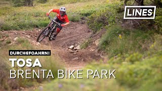
Photos of Brenta Bike Park Mountain Bike
trail: Tosa
48 |
Aug 18, 2020 @ 9:29am
Aug 18, 2020Videos of Brenta Bike Park Mountain Bike
trail: Tosa
7:50 |
238 |
Aug 20, 2019 , Madonna di Campiglio
Recent Trail Reports
| status | trail | date | condition | info | user |
|---|---|---|---|---|---|
| Bregn de l'Ors - Lago Valdagola | Aug 3, 2021 @ 7:39am Aug 3, 2021 | Wet | gion86 | ||
| Sfulmini | Aug 25, 2020 @ 11:59pm Aug 25, 2020 | Dry | pietrolaudano |
Activity Feed
| username | action | type | title | date | |
|---|---|---|---|---|---|
 | goodyear1966 | ridden | trail | Bregn de l'Ors - Lago Valdagola | Jan 26, 2022 @ 3:18am Jan 26, 2022 |
 | Sanski | wishlist | trail | Vallon and 1 more | Aug 15, 2021 @ 7:34am Aug 15, 2021 |
| Sanski | wishlist | trail | Pra Rodont - Pinzolo | Aug 8, 2021 @ 2:10am Aug 8, 2021 |
 | gion86 | add | report | Bregn de l'Ors - Lago Valdagola | Aug 3, 2021 @ 12:26pm Aug 3, 2021 |
| MarcoM73 | wishlist | trail | Bregn de l'Ors - Lago Valdagola | Jul 29, 2021 @ 11:53pm Jul 29, 2021 |
Nearby Areas
| name | distance | ||||
|---|---|---|---|---|---|
| Madonna di Campiglio Bike Land | 1 | 5 | 1 | 3.9 km | |
| Molveno ZONE | 2 | 2 | 1 | 7.8 km | |
| Dolomiti Paganella Bike | 1 | 4 | 4 | 9.3 km | |
| Comano Terme | 1 | 9.9 km | |||
| Val di Sole Bike Land | 29 | 6 | 3 | 10.1 km |
Activity Type Stats
| activitytype | trails | distance | descent | descent distance | total vertical | rating | global rank | state rank | photos | reports | routes | ridelogs |
|---|---|---|---|---|---|---|---|---|---|---|---|---|
| Mountain Bike | 6 | 8 miles | 8,064 ft | 7 miles | 4,058 ft | #9,365 | #462 | 1 | 4 | 114 | ||
| E-Bike | 5 | 7 miles | 7,221 ft | 7 miles | 4,058 ft | #3,339 | #340 | 3 | 7 | |||
| Hike | 2 | 3 miles | 3,002 ft | 3 miles | 3,307 ft | 4 | 5 | |||||
| Trail Running | 2 | 3 miles | 3,002 ft | 3 miles | 3,307 ft | 4 |
- By Dolomeet & contributors
- Admins: apply
- #24857 - 1,884 views
- brenta bike park activity log | embed map of Brenta Bike Park mountain bike trails |
Downloading of trail gps tracks in kml & gpx formats is enabled for Brenta Bike Park.
You must login to download files.