close
Trail Conditions
- Unknown
- Snow Groomed
- Snow Packed
- Snow Covered
- Snow Cover Inadequate
- Freeze/thaw Cycle
- Icy
- Prevalent Mud
- Wet
- Variable
- Ideal
- Dry
- Very Dry
Trail Flow (Ridden Direction)
Trailforks scans users ridelogs to determine the most popular direction each trail is ridden. A good flowing trail network will have most trails flowing in a single direction according to their intension.
The colour categories are based on what percentage of riders are riding a trail in its intended direction.
The colour categories are based on what percentage of riders are riding a trail in its intended direction.
- > 96%
- > 90%
- > 80%
- > 70%
- > 50%
- < 50%
- bi-directional trail
- no data
Trail Last Ridden
Trailforks scans ridelogs to determine the last time a trail was ridden.
- < 2 days
- < 1 week
- < 2 weeks
- < 1 month
- < 6 months
- > 6 months
Trail Ridden Direction
The intended direction a trail should be ridden.
- Downhill Only
- Downhill Primary
- Both Directions
- Uphill Primary
- Uphill Only
- One Direction
Contribute Details
Colors indicate trail is missing specified detail.
- Description
- Photos
- Description & Photos
- Videos
Trail Popularity ?
Trailforks scans ridelogs to determine which trails are ridden the most in the last 9 months.
Trails are compared with nearby trails in the same city region with a possible 25 colour shades.
Think of this as a heatmap, more rides = more kinetic energy = warmer colors.
- most popular
- popular
- less popular
- not popular
ATV/ORV/OHV Filter
Max Vehicle Width
inches
Radar Time
x
Activity Recordings
Trailforks users anonymized public ridelogs from the past 6 months.
- mountain biking recent
- mountain biking (>6 month)
- hiking (1 year)
- moto (1 year)
Activity Recordings
Trailforks users anonymized public skilogs from the past 12 months.
- Downhill Ski
- Backcountry Ski
- Nordic Ski
Jump Magnitude Heatmap
Heatmap of where riders jump on trails. Zoom in to see individual jumps, click circles to view jump details.
Trails Deemphasized
Trails are shown in grey.
Only show trails with NO bikes.
Save the current map location and zoom level as your default home location whenever this page is loaded.
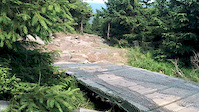
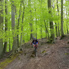
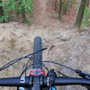
SaveJeden z najbardziej znanych bike park'ów w Polsce. Dwa wyciągi: Luxtorpeda i Efka. Mnóstwo tras, od prostych, po jedne z najtrudniejszych w Polsce. Strefa dla dzieci, restauracje, wypożyczalnie rowerów, szkolenia.
Primary Trail Type: All-Mountain & Downhill
Land Status: State Forest
 google parking directions
Links
- http://czarnagora.pl/bike-park/
- https://www.facebook.com/bikeparkczarnagora/
- https://czarnagora.pl
- https://www.facebook.com/CzarnaGoraResort/
This region uses the Uk/Euro style trail grading system.
Activities Click to view
- Mountain Bike
21 trails
- E-Bike
3 trails
- Downhill Ski
0 trails
- Backcountry Ski
0 trails
- Nordic Ski
0 trails
Bike Park Details
- 3
- 1
- 4
- 5
- 7
- 1
Region Status
Open as of May 23, 2021- Day Ticket
- zł99 PLN
- Uplift Type
- Chair Lift
- Season start
- May 7
- Season end
- Oct 30
Stats
- Avg Trail Rating
- Trails (view details)
- 21
- Trails Mountain Bike
- 21
- Trails E-Bike
- 3
- Trails Hike
- 3
- Trails Trail Running
- 3
- Total Distance
- 16 miles
- Total Descent Distance
- 12 miles
- Total Descent
- 10,781 ft
- Total Vertical
- 1,251 ft
- Highest Trailhead
- 3,835 ft
- Reports
- 159
- Photos
- 262
- Ridden Counter
- 3,199
Popular Czarna Góra Mountain Biking Trails
Czarna Góra Mountain Bike Routes
| title | rating | distance |
|---|---|---|
| race | 2,297 ft | |
| race | 1 mile |
Photos of Czarna Góra Mountain Bike
trail: Luxtorpeda
47 |
Oct 16, 2021 @ 11:32am
Oct 16, 2021
trail: DH Lux
41 |
Oct 16, 2021 @ 11:32am
Oct 16, 2021
trail: Luxtorpeda
22 |
Oct 16, 2021 @ 11:32am
Oct 16, 2021
trail: Family
67 |
Jul 12, 2021 @ 1:33pm
Jul 12, 2021
trail: DH Torpeda
57 | | 2 comments
Jul 12, 2021 @ 1:32pm
Jul 12, 2021
trail: DH Torpeda
69 |
Jul 12, 2021 @ 1:31pm
Jul 12, 2021
trail: DH Lux
97 |
Sep 29, 2020 @ 11:38am
Sep 29, 2020
trail: Milky Way
491 | | 5 comments
Sep 29, 2020 @ 11:30am
Sep 29, 2020Videos of Czarna Góra Mountain Bike


Recent Trail Reports
| status | trail | date | condition | info | user |
|---|---|---|---|---|---|
| Milky Way | Jun 17, 2022 @ 1:48am Jun 17, 2022 | Ideal | Kasiijja | ||
| Żmija | Jun 17, 2022 @ 1:48am Jun 17, 2022 | Variable | Kasiijja | ||
| DH Lux | Jun 17, 2022 @ 1:48am Jun 17, 2022 | Ideal | Kasiijja | ||
| Dzik | Jun 17, 2022 @ 1:48am Jun 17, 2022 | Variable | Kasiijja | ||
| Kambodża | Jun 17, 2022 @ 1:48am Jun 17, 2022 | Ideal | Kasiijja | ||
| Whipe Line | Jun 17, 2022 @ 1:48am Jun 17, 2022 | Ideal | Kasiijja | ||
| Kalifornia | Jun 17, 2022 @ 1:48am Jun 17, 2022 | Ideal | Kasiijja | ||
| Sowa | Jun 17, 2022 @ 1:48am Jun 17, 2022 | Variable | Kasiijja | ||
| Freeride | Jun 17, 2022 @ 1:48am Jun 17, 2022 | Ideal | Kasiijja | ||
| Access Road | Jun 17, 2022 @ 1:48am Jun 17, 2022 | Ideal | Kasiijja |
Activity Feed
| username | action | type | title | date | |
|---|---|---|---|---|---|
 | AdamPonec | ridden | trail | Dzik | Jun 24, 2022 @ 4:01am Jun 24, 2022 |
 | Kasiijja | add | report | Milky Way and 10 more | Jun 17, 2022 @ 11:15pm Jun 17, 2022 |
 | Thierryb8NY7H | wishlist | trail | Milky Way | Jun 15, 2022 @ 11:31pm Jun 15, 2022 |
| muhone | comment | trail | Klakier | Jun 4, 2022 @ 9:39am Jun 4, 2022 |
| muhone | add | report | Milky Way | Jun 3, 2022 @ 1:25pm Jun 3, 2022 |
Recent Comments
| username | type | title | comment | date | |
|---|---|---|---|---|---|
| trail | Dzika, naturalna. | Jun 4, 2022 @ 9:39am Jun 4, 2022 | ||
 | trail | Radzę uważać na tej trasie, jakkolwiek... | May 27, 2022 @ 6:06am May 27, 2022 | ||
 | trail | Wyciąg szybki, wygodny, przyjemny, ale ma... | Oct 17, 2021 @ 2:04am Oct 17, 2021 | ||
 | trail | Very difficult to ride blind, turns and drops... | Jul 1, 2021 @ 9:11am Jul 1, 2021 | ||
 | trail | więcej takich | Jun 12, 2021 @ 2:11pm Jun 12, 2021 |
Nearby Areas
| name | distance | ||||
|---|---|---|---|---|---|
| Glacensis Międzygórze | 4 | 3 | 2.6 km | ||
| Glacensis Stronie Śląskie | 2 | 4 | 3.8 km | ||
| Glacensis Lądek Zdrój | 4 | 4 | 6.9 km | ||
| Trail Park Dolní Morava | 1 | 1 | 7.4 km | ||
| Glacensis Międzylesie | 3 | 2 | 9.7 km |
Local Badges
-

Completionist0 awarded
Activity Type Stats
| activitytype | trails | distance | descent | descent distance | total vertical | rating | global rank | state rank | photos | reports | routes | ridelogs |
|---|---|---|---|---|---|---|---|---|---|---|---|---|
| Mountain Bike | 21 | 16 miles | 10,781 ft | 12 miles | 1,250 ft | #1,657 | #16 | 262 | 159 | 2 | 1,601 | |
| E-Bike | 3 | 3 miles | 39 ft | 1,060 ft | 1,040 ft | #82 | 131 | 1 | 54 | |||
| Hike | 3 | 3 miles | 39 ft | 1,060 ft | 1,040 ft | #90 | 149 | 46 | ||||
| Trail Running | 3 | 3 miles | 39 ft | 1,060 ft | 1,040 ft | #91 | 149 | 1 |
- By bartek457
 TRAILFORKS FS & contributors
 - Admins: apply
- #11521 - 8,279 views
- czarna góra activity log | embed map of Czarna Góra mountain bike trails | czarna góra mountain biking points of interest
-
- subscribe
- 3d map
Downloading of trail gps tracks in kml & gpx formats is enabled for Czarna Góra.
You must login to download files.