close
Trail Conditions
- Unknown
- Snow Groomed
- Snow Packed
- Snow Covered
- Snow Cover Inadequate
- Freeze/thaw Cycle
- Icy
- Prevalent Mud
- Wet
- Variable
- Ideal
- Dry
- Very Dry
Trail Flow (Ridden Direction)
Trailforks scans users ridelogs to determine the most popular direction each trail is ridden. A good flowing trail network will have most trails flowing in a single direction according to their intension.
The colour categories are based on what percentage of riders are riding a trail in its intended direction.
The colour categories are based on what percentage of riders are riding a trail in its intended direction.
- > 96%
- > 90%
- > 80%
- > 70%
- > 50%
- < 50%
- bi-directional trail
- no data
Trail Last Ridden
Trailforks scans ridelogs to determine the last time a trail was ridden.
- < 2 days
- < 1 week
- < 2 weeks
- < 1 month
- < 6 months
- > 6 months
Trail Ridden Direction
The intended direction a trail should be ridden.
- Downhill Only
- Downhill Primary
- Both Directions
- Uphill Primary
- Uphill Only
- One Direction
Contribute Details
Colors indicate trail is missing specified detail.
- Description
- Photos
- Description & Photos
- Videos
Trail Popularity ?
Trailforks scans ridelogs to determine which trails are ridden the most in the last 9 months.
Trails are compared with nearby trails in the same city region with a possible 25 colour shades.
Think of this as a heatmap, more rides = more kinetic energy = warmer colors.
- most popular
- popular
- less popular
- not popular
ATV/ORV/OHV Filter
Max Vehicle Width
inches
Radar Time
x
Activity Recordings
Trailforks users anonymized public ridelogs from the past 6 months.
- mountain biking recent
- mountain biking (>6 month)
- hiking (1 year)
- moto (1 year)
Activity Recordings
Trailforks users anonymized public skilogs from the past 12 months.
- Downhill Ski
- Backcountry Ski
- Nordic Ski
Jump Magnitude Heatmap
Heatmap of where riders jump on trails. Zoom in to see individual jumps, click circles to view jump details.
Trails Deemphasized
Trails are shown in grey.
Only show trails with NO bikes.
Save the current map location and zoom level as your default home location whenever this page is loaded.
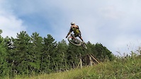
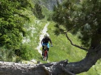
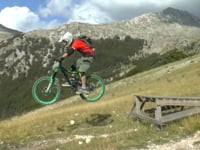
SaveFrontignano Bike Park is a riding area located around the Frontignano alpine skiing runs and maintained by Biocycle-Sibillini. The trails are "natural-style" enriched by several wooden structures: ramps, drops, berms, norths.
The upper part of the park is lift-served, and the bike-park runs are reserved to MTB & e-Bike.
During the last summer seasons the upper bike-park runs have been shuttle-served. Everybody can ride for free using the access road Ascent to Belvedere.
There are also several enduro trails with significant vertical drop, starting from the Frontignano village and descending to Ussita, to Castel Sant’Angelo or to Visso.
source: Biocycle Sibillini
Primary Trail Type: All-Mountain & Downhill
eBikes Allowed:
Yes
Shuttleable: YES
Land Status: Ski Resort
Access Info:
Piazzale Felycita or Cotto e Mangiato Chalet
Links
Activities Click to view
- Mountain Bike
28 trails
- E-Bike
24 trails
- Hike
10 trails
- Trail Running
12 trails
- Horse
6 trails
- Snowshoe
2 trails
- Downhill Ski
1 trails
- Backcountry Ski
1 trails
Bike Park Details
- 1
- 2
- 12
- 8
- 5
Region Status
Caution as of May 19, 2022Stats
- Avg Trail Rating
- Trails (view details)
- 28
- Trails Mountain Bike
- 28
- Trails E-Bike
- 24
- Trails Hike
- 10
- Trails Trail Running
- 12
- Trails Horse
- 6
- Trails Dirtbike/Moto
- 1
- Trails Snowmobile
- 1
- Trails Snowshoe
- 2
- Trails Downhill Ski
- 1
- Trails Backcountry Ski
- 1
- Trails Nordic Ski
- 1
- Total Distance
- 19 miles
- Total Descent Distance
- 14 miles
- Total Descent
- 11,561 ft
- Total Vertical
- 3,783 ft
- Highest Trailhead
- 5,801 ft
- Reports
- 109
- Photos
- 220
- Ridden Counter
- 613
Popular Frontignano Bike Park Mountain Biking Trails
Frontignano Bike Park Mountain Bike Routes
| title | rating | distance |
|---|---|---|
| Anello Piste Ripide - Steep Trails Ring | 12 miles | |
| Nel Cuore del Park - FBP Heart | 5 miles | |
| Tour Verde Facile - Easy Green Tour | 15 miles | |
| Anello del Torrone - Torrone Ring | 6 miles |
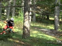
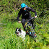
Photos of Frontignano Bike Park Mountain Bike
trail: Fun Cool
3 |
May 19, 2022 @ 9:41am
May 19, 2022
trail: Fun Cool
2 |
May 19, 2022 @ 9:41am
May 19, 2022
trail: Fun Cool
2 |
May 19, 2022 @ 9:41am
May 19, 2022
trail: Saliere
0 |
May 19, 2022 @ 9:33am
May 19, 2022
trail: Saliere
0 |
May 19, 2022 @ 9:33am
May 19, 2022
trail: Saliere
0 |
May 19, 2022 @ 9:33am
May 19, 2022
trail: Pino Torto
40 |
May 10, 2021 @ 12:41am
May 10, 2021
trail: Pino Torto Reloaded
36 |
May 10, 2021 @ 12:35am
May 10, 2021Videos of Frontignano Bike Park Mountain Bike

trail: Ciclamino - Alto
5:32 |
59 |
May 11, 2021 , Ussita
trail: Ascent to Ciclamino
5:32 |
54 |
May 11, 2021 , Ussita
trail: Fonte del Lupo
8:01 |
80 |
May 11, 2021 , Ussita

6:06 |
54 |
May 10, 2021 , Ussita
trail: Fine Piste FBP
6:06 |
51 |
May 10, 2021 , Ussita

trail: Pino Torto
6:06 |
60 |
May 10, 2021 , Ussita

trail: Fun Cool
6:06 |
76 |
May 10, 2021 , Ussita
trail: Ciclamino - Alto
3:43 |
61 |
May 10, 2021 , Ussita
Recent Trail Reports
| status | trail | date | condition | info | user |
|---|---|---|---|---|---|
| Raccordo Fun Cool > Aristde | Jun 1, 2022 @ 6:04am Jun 1, 2022 | Ideal | vettore | ||
| Sasso Corsara - Alto | May 26, 2022 @ 11:25am May 26, 2022 | Ideal | vettore | ||
| Scoiattolo Passeggiata | May 19, 2022 @ 9:49am May 19, 2022 | Ideal | vettore | ||
| Sasso Corsara - Basso | May 19, 2022 @ 9:48am May 19, 2022 | Variable | vettore | ||
| Chicken Line Fine Piste | May 19, 2022 @ 9:47am May 19, 2022 | Ideal | vettore | ||
| Scoiattolo Parte Bassa | May 19, 2022 @ 9:46am May 19, 2022 | Ideal | vettore | ||
| Raccordo Pino Torto - Fine Piste | May 19, 2022 @ 9:45am May 19, 2022 | Ideal | vettore | ||
| Pino Torto Variante | May 19, 2022 @ 9:44am May 19, 2022 | Ideal | vettore | ||
| Fonte del Lupo | May 19, 2022 @ 9:42am May 19, 2022 | Variable | vettore | ||
| Pino Torto Intro | May 19, 2022 @ 9:42am May 19, 2022 | Ideal | vettore |
Activity Feed
| username | action | type | title | date | |
|---|---|---|---|---|---|
 | Lekx | wishlist | region | Frontignano Bike Park | Jun 26, 2022 @ 6:15am Jun 26, 2022 |
| PablogtCastello | ridden | trail | Ciclamino - Alto | Jun 2, 2022 @ 8:51am Jun 2, 2022 |
 | vettore | add | report | Raccordo Fun Cool > Aristde | Jun 1, 2022 @ 6:04am Jun 1, 2022 |
| vettore | add | report | Sasso Corsara - Alto | May 26, 2022 @ 11:26am May 26, 2022 |
| vettore | update | trail | Pino Torto Intro and 7 more | May 24, 2022 @ 12:51am May 24, 2022 |
Recent Comments
| username | type | title | comment | date | |
|---|---|---|---|---|---|
| report | È | Jun 3, 2021 @ 1:51pm Jun 3, 2021 | ||
| report | Grazie del report. Questa pista non è stata... | Jun 3, 2021 @ 2:33am Jun 3, 2021 | ||
| report | Grazie molte del report. Le uniche piste ad... | Jun 3, 2021 @ 2:31am Jun 3, 2021 | ||
| report | Many thanks fro your report | Jun 3, 2021 @ 1:13am Jun 3, 2021 | ||
| report | Many thanks for your report! | Jun 3, 2021 @ 1:12am Jun 3, 2021 |
Nearby Areas
| name | distance | ||||
|---|---|---|---|---|---|
| Parco Nazionale dei Monti Sibillini | 2 | 2 | 1 | 7.1 km | |
| Trevi | 20 | 28 | 3 | 19.3 km | |
| Pale | 14 | 14 | 6 | 19.8 km | |
| Sassovivo | 35 | 27 | 3 | 3 | 20 km |
| Cupacci-Chiona | 6 | 5 | 1 | 22.6 km |
Local Badges
-

Completionist0 awarded
Activity Type Stats
| activitytype | trails | distance | descent | descent distance | total vertical | rating | global rank | state rank | photos | reports | routes | ridelogs |
|---|---|---|---|---|---|---|---|---|---|---|---|---|
| Mountain Bike | 28 | 19 miles | 11,562 ft | 14 miles | 3,783 ft | #4,840 | #197 | 219 | 109 | 4 | 98 | |
| E-Bike | 24 | 18 miles | 10,968 ft | 13 miles | 3,783 ft | #1,766 | #137 | 1 | 85 | 4 | 25 | |
| Hike | 10 | 12 miles | 5,712 ft | 7 miles | 3,783 ft | #4,951 | #220 | 28 | 10 | |||
| Trail Running | 12 | 14 miles | 7,382 ft | 9 miles | 3,783 ft | #4,464 | #188 | 36 | 1 | |||
| Horse | 6 | 10 miles | 4,259 ft | 6 miles | 3,783 ft | #304 | #8 | 14 | ||||
| Dirtbike/Moto | 1 | 2 miles | 837 ft | |||||||||
| Snowmobile | 1 | 2 miles | 837 ft | |||||||||
| Snowshoe | 2 | 3 miles | 75 ft | 2,047 ft | 922 ft | #184 | #2 | 2 | ||||
| Downhill Ski | 1 | 2,047 ft | 75 ft | 2,047 ft | 85 ft | #10 | #1 | 2 | ||||
| Backcountry Ski | 1 | 2,047 ft | 75 ft | 2,047 ft | 85 ft | #6 | 1 | |||||
| Nordic Ski | 1 | 2 miles | 837 ft |
- By denitopia
 TRAILFORKS & contributors
 - Admins: vettore
- #45423 - 2,293 views
- frontignano bike park activity log | embed map of Frontignano Bike Park mountain bike trails | frontignano bike park mountain biking points of interest
Downloading of trail gps tracks in kml & gpx formats is enabled for Frontignano Bike Park.
You must login to download files.