close
Trail Conditions
- Unknown
- Snow Groomed
- Snow Packed
- Snow Covered
- Snow Cover Inadequate
- Freeze/thaw Cycle
- Icy
- Prevalent Mud
- Wet
- Variable
- Ideal
- Dry
- Very Dry
Trail Flow (Ridden Direction)
Trailforks scans users ridelogs to determine the most popular direction each trail is ridden. A good flowing trail network will have most trails flowing in a single direction according to their intension.
The colour categories are based on what percentage of riders are riding a trail in its intended direction.
The colour categories are based on what percentage of riders are riding a trail in its intended direction.
- > 96%
- > 90%
- > 80%
- > 70%
- > 50%
- < 50%
- bi-directional trail
- no data
Trail Last Ridden
Trailforks scans ridelogs to determine the last time a trail was ridden.
- < 2 days
- < 1 week
- < 2 weeks
- < 1 month
- < 6 months
- > 6 months
Trail Ridden Direction
The intended direction a trail should be ridden.
- Downhill Only
- Downhill Primary
- Both Directions
- Uphill Primary
- Uphill Only
- One Direction
Contribute Details
Colors indicate trail is missing specified detail.
- Description
- Photos
- Description & Photos
- Videos
Trail Popularity ?
Trailforks scans ridelogs to determine which trails are ridden the most in the last 9 months.
Trails are compared with nearby trails in the same city region with a possible 25 colour shades.
Think of this as a heatmap, more rides = more kinetic energy = warmer colors.
- most popular
- popular
- less popular
- not popular
ATV/ORV/OHV Filter
Max Vehicle Width
inches
Radar Time
x
Activity Recordings
Trailforks users anonymized public ridelogs from the past 6 months.
- mountain biking recent
- mountain biking (>6 month)
- hiking (1 year)
- moto (1 year)
Activity Recordings
Trailforks users anonymized public skilogs from the past 12 months.
- Downhill Ski
- Backcountry Ski
- Nordic Ski
Jump Magnitude Heatmap
Heatmap of where riders jump on trails. Zoom in to see individual jumps, click circles to view jump details.
Trails Deemphasized
Trails are shown in grey.
Only show trails with NO bikes.
Save the current map location and zoom level as your default home location whenever this page is loaded.
SaveWe can write about our trails and paint a pretty picture, but the truth is, you simply need to experience what all the fuss is all about. With over 30km of main trails, linked up with another 10km of alternative routes, you will be astounded by the variety of ways you can approach these trails. In a nutshell this is single track heaven and once ridden will keep you coming back again and again
source: Giba Gorge
Primary Trail Type: All-Mountain & Downhill
eBikes Allowed:
Yes
Shuttleable: YES
Land Status: Private Property
 google parking directions
Links
Region Supporters & Maintainers
trail builderSponsor
Activities Click to view
- Mountain Bike
59 trails
- E-Bike
30 trails
- Hike
41 trails
- Trail Running
41 trails
Bike Park Details
- 8
- 7
- 29
- 13
- 2
Region Status
Open as of May 8, 2022- Day Ticket
- 75 ZAR
Stats
- Avg Trail Rating
- Trails (view details)
- 59
- Trails Mountain Bike
- 59
- Trails E-Bike
- 30
- Trails Hike
- 41
- Trails Trail Running
- 41
- Trails Horse
- 4
- Total Distance
- 26 miles
- Total Descent Distance
- 14 miles
- Total Descent
- 5,016 ft
- Total Vertical
- 756 ft
- Highest Trailhead
- 1,909 ft
- Reports
- 218
- Photos
- 177
- Ridden Counter
- 2,499
Popular Giba Gorge MTB Park Mountain Biking Trails
Giba Gorge MTB Park Mountain Bike Routes
| title | rating | distance |
|---|---|---|
| GIBA PURPLE ROUTE | 2 miles | |
| GIBA BLUE ROUTE | 9 miles | |
| GIBA GREEN ROUTE | 7 miles | |
| 11 mile Giba Gorge MTB Park Ride | popular ridelog | 11 miles |
| 11 mile Giba Gorge MTB Park All-Mountain Ride | popular ridelog | 11 miles |
Photos of Giba Gorge MTB Park Mountain Bike
trail: Gibaland Driveway
39 |
Apr 14, 2021 @ 4:43am
Apr 14, 2021
trail: Gibaland Driveway
40 |
Apr 14, 2021 @ 4:43am
Apr 14, 2021
trail: Gibaland Driveway
34 |
Apr 14, 2021 @ 4:43am
Apr 14, 2021
trail: Gibaland Driveway
42 |
Apr 14, 2021 @ 4:43am
Apr 14, 2021
trail: Gibaland Driveway
30 |
Apr 14, 2021 @ 4:43am
Apr 14, 2021
trail: Gibaland Driveway
31 |
Apr 14, 2021 @ 4:43am
Apr 14, 2021
trail: Gibaland Driveway
33 |
Apr 14, 2021 @ 4:43am
Apr 14, 2021
trail: Gibaland Driveway
31 |
Apr 14, 2021 @ 4:43am
Apr 14, 2021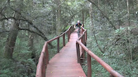

Recent Trail Reports
| status | trail | date | condition | info | user |
|---|---|---|---|---|---|
| Q'd | Sep 15, 2021 @ 12:09am Sep 15, 2021 | Ideal | kyran12 | ||
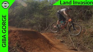
| Land Invasion | Sep 15, 2021 @ 12:08am Sep 15, 2021 | Very Dry | kyran12 | ||
| 3 BRIDGES | May 28, 2021 @ 6:28am May 28, 2021 | Dry | linnega | ||
| Jethros Jaunt | May 28, 2021 @ 6:28am May 28, 2021 | Dry | linnega | ||
| Shayamoya | May 28, 2021 @ 6:28am May 28, 2021 | Very Dry | linnega | ||
| NARROW TRAIL | May 28, 2021 @ 6:28am May 28, 2021 | Dry | linnega | ||
| Easy Blue | May 28, 2021 @ 6:28am May 28, 2021 | Ideal | linnega | ||
| Blue High | May 28, 2021 @ 6:28am May 28, 2021 | Unknown | linnega | ||
| Gravity Dice Dam Drop | May 28, 2021 @ 6:28am May 28, 2021 | Ideal | linnega | ||
| Bizhub 1 | May 28, 2021 @ 6:28am May 28, 2021 | Ideal | linnega |
Activity Feed
| username | action | type | title | date | |
|---|---|---|---|---|---|
 | khIpT | wishlist | route | GIBA BLUE ROUTE | Jul 4, 2022 @ 6:37am 2 days |
| Talisman | ridden | trail | Shayamoya and 1 more | Nov 28, 2021 @ 3:37am Nov 28, 2021 |
| HABez | ridden | trail | Servitude Path to Bench | Nov 3, 2021 @ 11:35pm Nov 3, 2021 |
 | kyran12 | vote | trail | Shayamoya | Sep 15, 2021 @ 12:14am Sep 15, 2021 |
| kyran12 | add | report | Land Invasion and 1 more | Sep 15, 2021 @ 12:09am Sep 15, 2021 |
Nearby Areas
| name | distance | ||||
|---|---|---|---|---|---|
| EMBA Shongweni Trails | 1 | 2.5 km | |||
| Valley of 1000 Hills | 1 | 9.7 km | |||
| Kenneth Stainbank Nature Reserve | 5 | 11.6 km | |||
| Virginia Farm | 1 | 11 | 15.6 km | ||
| iNsingizi Lodge & Spa Mountain Biking Trails | 5 | 19.2 km |
Local Badges
-

Completionist0 awarded
Bike & Skill Parks
| name | type | city | rating |
|---|---|---|---|
| BMX Track | skill park | Durban | |
| Kids YBike Track | skill park | Durban |
Activity Type Stats
| activitytype | trails | distance | descent | descent distance | total vertical | rating | global rank | state rank | photos | reports | routes | ridelogs |
|---|---|---|---|---|---|---|---|---|---|---|---|---|
| Mountain Bike | 59 | 26 miles | 5,016 ft | 14 miles | 758 ft | #1,977 | #33 | 177 | 218 | 3 | 3,493 | |
| E-Bike | 30 | 15 miles | 2,264 ft | 6 miles | 709 ft | #559 | #20 | 214 | 3 | 72 | ||
| Hike | 41 | 21 miles | 3,133 ft | 10 miles | 758 ft | #1,837 | #31 | 216 | 2 | 17 | ||
| Trail Running | 41 | 21 miles | 3,133 ft | 10 miles | 758 ft | #1,845 | #31 | 216 | 3 | 13 | ||
| Horse | 4 | 2 miles | 62 ft | 1,322 ft | 417 ft | 33 | 1 |
- By FionaWilliams
 Giba & contributors
 - Admins: Giba
- #5344 - 6,948 views
- giba gorge mtb park activity log | embed map of Giba Gorge MTB Park mountain bike trails | giba gorge mtb park mountain biking points of interest
-
- subscribe
- 3d map
Downloading of trail gps tracks in kml & gpx formats is enabled for Giba Gorge MTB Park.
You must login to download files.