close
Trail Conditions
- Unknown
- Snow Groomed
- Snow Packed
- Snow Covered
- Snow Cover Inadequate
- Freeze/thaw Cycle
- Icy
- Prevalent Mud
- Wet
- Variable
- Ideal
- Dry
- Very Dry
Trail Flow (Ridden Direction)
Trailforks scans users ridelogs to determine the most popular direction each trail is ridden. A good flowing trail network will have most trails flowing in a single direction according to their intension.
The colour categories are based on what percentage of riders are riding a trail in its intended direction.
The colour categories are based on what percentage of riders are riding a trail in its intended direction.
- > 96%
- > 90%
- > 80%
- > 70%
- > 50%
- < 50%
- bi-directional trail
- no data
Trail Last Ridden
Trailforks scans ridelogs to determine the last time a trail was ridden.
- < 2 days
- < 1 week
- < 2 weeks
- < 1 month
- < 6 months
- > 6 months
Trail Ridden Direction
The intended direction a trail should be ridden.
- Downhill Only
- Downhill Primary
- Both Directions
- Uphill Primary
- Uphill Only
- One Direction
Contribute Details
Colors indicate trail is missing specified detail.
- Description
- Photos
- Description & Photos
- Videos
Trail Popularity ?
Trailforks scans ridelogs to determine which trails are ridden the most in the last 9 months.
Trails are compared with nearby trails in the same city region with a possible 25 colour shades.
Think of this as a heatmap, more rides = more kinetic energy = warmer colors.
- most popular
- popular
- less popular
- not popular
ATV/ORV/OHV Filter
Max Vehicle Width
inches
Radar Time
x
Activity Recordings
Trailforks users anonymized public ridelogs from the past 6 months.
- mountain biking recent
- mountain biking (>6 month)
- hiking (1 year)
- moto (1 year)
Activity Recordings
Trailforks users anonymized public skilogs from the past 12 months.
- Downhill Ski
- Backcountry Ski
- Nordic Ski
Jump Magnitude Heatmap
Heatmap of where riders jump on trails. Zoom in to see individual jumps, click circles to view jump details.
Trails Deemphasized
Trails are shown in grey.
Only show trails with NO bikes.
Save the current map location and zoom level as your default home location whenever this page is loaded.
SaveA ski centre with a single trail accessed by a chairlift during summer.
Primary Trail Type: All-Mountain & Downhill
Land Status: National Park
This region uses the Uk/Euro style trail grading system.
Activities Click to view
- Mountain Bike
2 trails
- E-Bike
0 trails
- Hike
0 trails
- Trail Running
0 trails
- Downhill Ski
28 trails
Region Details
- 1
Region Status
Open as of Jul 2, 2022- Day Ticket
- £15 GBP
- Uplift Type
- Chair Lift
Stats
- Avg Trail Rating
- Trails (view details)
- 29
- Trails Mountain Bike
- 2
- Trails Downhill Ski
- 28
- Total Distance
- 14 miles
- Total Descent
- 10,287 ft
- Total Vertical
- 1,226 ft
- Highest Trailhead
- 3,356 ft
- Reports
- 4
- Photos
- 1
- Ridden Counter
- 390
Popular Glenshee Mountain Biking Trails
| status | title | difficulty | rating |
|---|---|---|---|
| Meall Odhar DH |
Glenshee Mountain Bike Routes
| title | rating | distance |
|---|---|---|
| Beinn a'Bhuird anticlockwise | 25 miles |
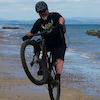
Photos of Glenshee Mountain Bike
trail: Landrover Track Descent
259 |
Jun 22, 2019 @ 11:41am
Jun 22, 2019Recent Trail Reports
| status | trail | date | condition | info | user |
|---|---|---|---|---|---|
| Landrover Track Descent w | Feb 26, 2020 @ 2:50am Feb 26, 2020 | Snow Groomed | imevil007 |
Activity Feed
| username | action | type | title | date | |
|---|---|---|---|---|---|
 | Jbrooksby | wishlist | route | Beinn a'Bhuird anticlockwise | Jun 27, 2022 @ 2:22pm Jun 27, 2022 |
| Lcoxy | ridden | route | Beinn a'Bhuird anticlockwise | Jun 25, 2022 @ 1:16pm Jun 25, 2022 |
| Albennett | wishlist | trail | Meall Odhar DH | Jul 12, 2021 @ 8:03am Jul 12, 2021 |
| Lunarross | ridden | trail | Meall Odhar DH | Nov 1, 2020 @ 8:53am Nov 1, 2020 |
 | tomoz | add | photo | in Aberdeenshire, United Kingdom | Jun 22, 2019 @ 11:41am Jun 22, 2019 |
Nearby Areas
| name | distance | ||||
|---|---|---|---|---|---|
| Glen Doll | 8.6 km | ||||
| Glen Tilt | 13.9 km | ||||
| Alyth Hill | 15 | 11 | 18.3 km | ||
| Pannanich | 6 | 18.5 km | |||
| Beinn Dearg | 18.5 km |
Activity Type Stats
| activitytype | trails | distance | descent | descent distance | total vertical | rating | global rank | state rank | photos | reports | routes | ridelogs |
|---|---|---|---|---|---|---|---|---|---|---|---|---|
| Mountain Bike | 2 | 3 miles | 1,663 ft | 2 miles | 840 ft | #10,795 | #491 | 1 | 1 | 1 | 201 | |
| Downhill Ski | 28 | 11 miles | 8,625 ft | 10 miles | 1,227 ft | #1 | 3 | 69 |
- By wisey
 TRAILFORKS & contributors
 - Admins: Gravitate, ATA, eastfyfes
- #19444 - 6,254 views
- glenshee activity log | embed map of Glenshee mountain bike trails | polygons
-
- subscribe
- 3d map
Downloading of trail gps tracks in kml & gpx formats is enabled for Glenshee.
You must login to download files.