close
Trail Conditions
- Unknown
- Snow Groomed
- Snow Packed
- Snow Covered
- Snow Cover Inadequate
- Freeze/thaw Cycle
- Icy
- Prevalent Mud
- Wet
- Variable
- Ideal
- Dry
- Very Dry
Trail Flow (Ridden Direction)
Trailforks scans users ridelogs to determine the most popular direction each trail is ridden. A good flowing trail network will have most trails flowing in a single direction according to their intension.
The colour categories are based on what percentage of riders are riding a trail in its intended direction.
The colour categories are based on what percentage of riders are riding a trail in its intended direction.
- > 96%
- > 90%
- > 80%
- > 70%
- > 50%
- < 50%
- bi-directional trail
- no data
Trail Last Ridden
Trailforks scans ridelogs to determine the last time a trail was ridden.
- < 2 days
- < 1 week
- < 2 weeks
- < 1 month
- < 6 months
- > 6 months
Trail Ridden Direction
The intended direction a trail should be ridden.
- Downhill Only
- Downhill Primary
- Both Directions
- Uphill Primary
- Uphill Only
- One Direction
Contribute Details
Colors indicate trail is missing specified detail.
- Description
- Photos
- Description & Photos
- Videos
Trail Popularity ?
Trailforks scans ridelogs to determine which trails are ridden the most in the last 9 months.
Trails are compared with nearby trails in the same city region with a possible 25 colour shades.
Think of this as a heatmap, more rides = more kinetic energy = warmer colors.
- most popular
- popular
- less popular
- not popular
ATV/ORV/OHV Filter
Max Vehicle Width
inches
Radar Time
x
Activity Recordings
Trailforks users anonymized public ridelogs from the past 6 months.
- mountain biking recent
- mountain biking (>6 month)
- hiking (1 year)
- moto (1 year)
Activity Recordings
Trailforks users anonymized public skilogs from the past 12 months.
- Downhill Ski
- Backcountry Ski
- Nordic Ski
Jump Magnitude Heatmap
Heatmap of where riders jump on trails. Zoom in to see individual jumps, click circles to view jump details.
Trails Deemphasized
Trails are shown in grey.
Only show trails with NO bikes.
Save the current map location and zoom level as your default home location whenever this page is loaded.
SaveSmall bike park on Golte mountain with four tracks: Downhill (black), Flow (blue), Freeride (red - not entirely finished yet) and a panorama Loop. Starting at Hotel Golte, way up on the mountain.
Primary Trail Type: All-Mountain & Downhill
Links
This region uses the Uk/Euro style trail grading system.
Activities Click to view
- Mountain Bike
1 trails
- Hike
0 trails
- Trail Running
0 trails
- Snowshoe
0 trails
- Downhill Ski
0 trails
- Backcountry Ski
0 trails
Region Details
Region Status
Open as of Feb 21, 2022- Uplift Type
- Chair Lift
Stats
- Avg Trail Rating
- Trails (view details)
- 1
- Trails Mountain Bike
- 1
- Total Distance
- 2,363 ft
- Total Descent
- 496 ft
- Total Vertical
- 496 ft
- Highest Trailhead
- 5,098 ft
- Photos
- 3
- Ridden Counter
- 3
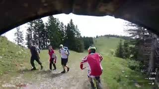
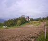
Photos of Golte Mountain Bike
trail: Bike Park Golte - Black
208 |
Sep 13, 2017 @ 2:02pm
Sep 13, 2017
trail: Bike Park Golte - Black
103 |
Sep 13, 2017 @ 2:01pm
Sep 13, 2017
trail: Bike Park Golte - Black
85 |
Sep 13, 2017 @ 2:01pm
Sep 13, 2017Videos of Golte Mountain Bike
trail: Bike Park Golte - Black
692 |
Aug 24, 2016 , My City
Activity Feed
| username | action | type | title | date | |
|---|---|---|---|---|---|
 | thijmenstar | ridden | trail | Bike Park Golte - Black | Jul 26, 2020 @ 12:53am Jul 26, 2020 |
 | Matjazoo | add | photo | at Bike Park Golte - Black in Mozirje, Slovenia and 2 more | Sep 13, 2017 @ 2:07pm Sep 13, 2017 |
 | zakskusek | wishlist | trail | Bike Park Golte - Black | Apr 19, 2017 @ 2:44am Apr 19, 2017 |
| SH4RKDOWNHILL | ridden | trail | Bike Park Golte - Black | Oct 22, 2016 @ 7:58am Oct 22, 2016 |
 | VjekoslavKrsanac | update | region | White Rabbit Bike Park Golte | Aug 24, 2016 @ 10:10am Aug 24, 2016 |
Nearby Areas
| name | distance | ||||
|---|---|---|---|---|---|
| Uršlja gora | 9.1 km | ||||
| Podpeca trails | 3 | 9.2 km | |||
| Vodemla Trails | 11.5 km | ||||
| Bike Park Poseka | 1 | 1 | 12.1 km | ||
| MTB-ZONE Bikepark Petzen | 1 | 12.5 km |
- By lines
 TRAILFORKS & contributors
 - Admins: VjekoslavKrsanac, zocknroll
- #15640 - 3,789 views
- golte activity log | embed map of Golte mountain bike trails |
-
- subscribe
- 3d map
Downloading of trail gps tracks in kml & gpx formats is enabled for Golte.
You must login to download files.