close
Trail Conditions
- Unknown
- Snow Groomed
- Snow Packed
- Snow Covered
- Snow Cover Inadequate
- Freeze/thaw Cycle
- Icy
- Prevalent Mud
- Wet
- Variable
- Ideal
- Dry
- Very Dry
Trail Flow (Ridden Direction)
Trailforks scans users ridelogs to determine the most popular direction each trail is ridden. A good flowing trail network will have most trails flowing in a single direction according to their intension.
The colour categories are based on what percentage of riders are riding a trail in its intended direction.
The colour categories are based on what percentage of riders are riding a trail in its intended direction.
- > 96%
- > 90%
- > 80%
- > 70%
- > 50%
- < 50%
- bi-directional trail
- no data
Trail Last Ridden
Trailforks scans ridelogs to determine the last time a trail was ridden.
- < 2 days
- < 1 week
- < 2 weeks
- < 1 month
- < 6 months
- > 6 months
Trail Ridden Direction
The intended direction a trail should be ridden.
- Downhill Only
- Downhill Primary
- Both Directions
- Uphill Primary
- Uphill Only
- One Direction
Contribute Details
Colors indicate trail is missing specified detail.
- Description
- Photos
- Description & Photos
- Videos
Trail Popularity ?
Trailforks scans ridelogs to determine which trails are ridden the most in the last 9 months.
Trails are compared with nearby trails in the same city region with a possible 25 colour shades.
Think of this as a heatmap, more rides = more kinetic energy = warmer colors.
- most popular
- popular
- less popular
- not popular
ATV/ORV/OHV Filter
Max Vehicle Width
inches
Radar Time
x
Activity Recordings
Trailforks users anonymized public ridelogs from the past 6 months.
- mountain biking recent
- mountain biking (>6 month)
- hiking (1 year)
- moto (1 year)
Activity Recordings
Trailforks users anonymized public skilogs from the past 12 months.
- Downhill Ski
- Backcountry Ski
- Nordic Ski
Jump Magnitude Heatmap
Heatmap of where riders jump on trails. Zoom in to see individual jumps, click circles to view jump details.
Trails Deemphasized
Trails are shown in grey.
Only show trails with NO bikes.
Save the current map location and zoom level as your default home location whenever this page is loaded.
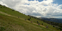
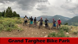
SaveWith spectacular Teton singletrack trails winding through wildflower meadows, and miles of technical lift-serviced downhill trails, Grand Targhee Resort established itself as the first downhill mountain bike destination in the region. Along with incredible trails on Teton Pass, the Big Holes, Jackson Hole Mountain Resort, and Snow King, the region is quickly becoming a mountain bike mecca. When it’s mid-summer and the West is sweltering, Grand Targhee and the Tetons offering cool temperatures, quality dirt, and incomparable scenery.
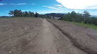
Explore over 2,200 vertical feet of lift-serviced downhill and over 70+ miles of cross country and downhill trails. We offer trails for every style of riding for every level of rider, from family-friendly flow trails, classic technical descents, jump lines, skills parks and more, we've got what you crave
Explore over 2,200 vertical feet of lift-serviced downhill and over 70+ miles of cross country and downhill trails. We offer trails for every style of riding for every level of rider, from family-friendly flow trails, classic technical descents, jump lines, skills parks and more, we've got what you crave
source: Grand Targhee Resort Bike Park
Primary Trail Type: All-Mountain & Downhill
Land Status: Ski Resort
Land Manager: Grand Targhee Bike Park
 google parking directions
 Access Info:
Drive east from Driggs, Idaho up Ski Hill Rd. Once you arrive at Grand Targhee Resort most of the trail begin from the main plaza. There is a large trails map adjacent to the Activity Center indicating direction, difficulty, and miles.
Links
Files
- Grand_Targhee_Bike_Park_Map.jpg (980 KB)
Region Supporters & Maintainers
![Grand Targhee Bike Park]()
Grand Targhee Bike ParkMaintainer
Activities Click to view
- Mountain Bike
63 trails
- Hike
11 trails
- Trail Running
11 trails
- Downhill Ski
28 trails
Bike Park Details
- 11
- 14
- 31
- 5
Region Status
Caution as of Sep 8, 2020- Day Ticket
- $41 USD
- Uplift Type
- Chair Lift
- Season start
- Jun 14
- Season end
- Sep 15
Stats
- Avg Trail Rating
- Trails (view details)
- 92
- Trails Mountain Bike
- 63
- Trails Hike
- 11
- Trails Trail Running
- 11
- Trails Downhill Ski
- 28
- Total Distance
- 97 miles
- Total Descent
- 36,546 ft
- Total Vertical
- 3,139 ft
- Highest Trailhead
- 9,851 ft
- Reports
- 522
- Photos
- 278
- Ridden Counter
- 22,994
Popular Grand Targhee Resort Mountain Biking Trails
Grand Targhee Resort Mountain Bike Routes
| title | rating | distance |
|---|---|---|
| Grand Targhee Loop - IMBA EPIC | 29 miles | |
| 2020 Pierre's Hole 50 K Lap & 100 K & 100 mile mtn bike race Lap 2-3 | 29 miles | |
| 2021 Nica Race Course | 5 miles | |
| 2021 GTR NICA RACE COURSE | 5 miles | |
| north mbt | 8 miles | |
| Bring it on Home | 1 mile | |
| Astro | 4,738 ft | |
| Teton Dirt Series 8/26 race | 9 miles | |
| Sidewinder to Astro | 4 miles | |
| Teton Dirt Series 8/26 race junior race | 5 miles |
Photos of Grand Targhee Resort Mountain Bike
trail: 38 Special
286 |
Jul 22, 2019 @ 11:26am
Jul 22, 2019
trail: 38 Special
204 |
Jul 8, 2019 @ 11:19pm
Jul 8, 2019
trail: Colter's Escape
68 |
Jun 18, 2018 @ 10:25pm
Jun 18, 2018
trail: Action Jackson
49 |
Jun 18, 2018 @ 10:09pm
Jun 18, 2018
trail: Cold Springs
27 |
Jun 18, 2018 @ 9:53pm
Jun 18, 2018
trail: Cold Springs
32 |
Jun 18, 2018 @ 9:50pm
Jun 18, 2018
trail: Mill Creek
225 |
Sep 6, 2015 @ 1:43pm
Sep 6, 2015
trail: Mill Creek
176 |
Sep 6, 2015 @ 1:42pm
Sep 6, 2015Videos of Grand Targhee Resort Mountain Bike
trail: Shake em on down
3:30 |
68 |
Jul 20, 2018
trail: Grand Traverse
0:59 |
54 |
Nov 18, 2017

trail: Rock Garden
13:41 |
343 |
Sep 7, 2012

trail: Mill Creek
28:11 |
96 |
Aug 26, 2021 , Alta

trail: Rocky Mountain Way
28:11 |
94 |
Aug 26, 2021 , Alta

trail: Andys
28:11 |
134 |
Aug 26, 2021 , Alta

trail: Bullwinkle
28:11 |
94 |
Aug 26, 2021 , Alta
trail: Sidewinder
28:11 |
86 |
Aug 26, 2021 , Alta
Recent Trail Reports
| status | trail | date | condition | info | user |
|---|---|---|---|---|---|
| Blondie | Jul 5, 2022 @ 6:14pm 8 hours | Ideal | nermol | ||
| Cold Springs | Jul 3, 2022 @ 6:35pm 2 days | Dry | straythots | ||
| Mill Creek | Jun 27, 2022 @ 2:31pm Jun 27, 2022 | Dry | cremebrule MBT | ||
| Perma-Grin | Oct 1, 2021 @ 8:55am Oct 1, 2021 | Dry | savesthejade | ||
| More Cowbell | Oct 1, 2021 @ 8:54am Oct 1, 2021 | Dry | savesthejade | ||
| Yogi | Aug 14, 2021 @ 3:54pm Aug 14, 2021 | Dry | allaroundjoe | ||
| Blackfoot Road | Aug 14, 2021 @ 3:54pm Aug 14, 2021 | Dry | allaroundjoe | ||
| Snowdrift Connect | Aug 14, 2021 @ 3:54pm Aug 14, 2021 | Dry | allaroundjoe | ||
| Pika | Aug 14, 2021 @ 3:54pm Aug 14, 2021 | Dry | allaroundjoe | ||
| Pika Traverse | Aug 14, 2021 @ 3:54pm Aug 14, 2021 | Dry | allaroundjoe |
Activity Feed
| username | action | type | title | date | |
|---|---|---|---|---|---|
 | nermol | add | report | Blondie | Jul 5, 2022 @ 6:14pm 8 hours |
| nermol | comment | trail | Blondie | Jul 5, 2022 @ 6:14pm 8 hours |
| nermol | vote | trail | Blondie | Jul 5, 2022 @ 6:12pm 8 hours |
 | robertellisw | comment | trail | Rock Garden | Jul 4, 2022 @ 5:23pm 1 day |
| verdepower | wishlist | route | 2022 Pierre's Hole 100 K Lap #1 and 1 more | Jul 4, 2022 @ 5:52am 2 days |
Recent Comments
| username | type | title | comment | date | |
|---|---|---|---|---|---|
| trail | What a great trail. Off camber, multiple line... | Jul 5, 2022 @ 6:14pm 8 hours | ||
| trail | Go for it! No resting necessary. Wear padded... | Jul 4, 2022 @ 5:23pm 1 day | ||
| trail | Really fun and flowy. Well laid out. Smooth. | Aug 14, 2021 @ 9:54pm Aug 14, 2021 | ||
| trail | Basic traverse connector trail. | Aug 14, 2021 @ 9:53pm Aug 14, 2021 | ||
| trail | OK trail. Like many others at resort but not... | Aug 14, 2021 @ 9:50pm Aug 14, 2021 |
Nearby Areas
| name | distance | ||||
|---|---|---|---|---|---|
| Northern Tetons | 10 | 9 | 4 | 8.7 km | |
| Central Lakes | 1 | 11.1 km | |||
| Jackson Hole Mountain Resort | 5 | 10 | 2 | 2 | 14.9 km |
| Horseshoe Canyon Trail System | 1 | 12 | 6 | 17.2 km | |
| Colter Bay | 1 | 17.4 km |
Local Badges
-

Completionist0 awarded
Bike & Skill Parks
| name | type | city | rating |
|---|---|---|---|
| Drop zone | skill park | Alta | |
| Skills park | skill park | Alta |
Activity Type Stats
| activitytype | trails | distance | descent | descent distance | total vertical | rating | global rank | state rank | photos | reports | routes | ridelogs |
|---|---|---|---|---|---|---|---|---|---|---|---|---|
| Mountain Bike | 63 | 81 miles | 17,694 ft | 39 miles | 3,140 ft | #267 | #121 | 276 | 522 | 36 | 7,153 | |
| Hike | 11 | 9 miles | 1,132 ft | 4 miles | 764 ft | #1,793 | #1,047 | 406 | 1 | 162 | ||
| Trail Running | 11 | 9 miles | 1,132 ft | 4 miles | 764 ft | #1,796 | #1,044 | 403 | 1 | 28 | ||
| Downhill Ski | 28 | 13 miles | 18,806 ft | 13 miles | 2,260 ft | #136 | 95 | 1,086 |
- By grandtargheebikepark & contributors
- Admins: grandtargheebikepark
- #7173 - 15,281 views
- grand targhee resort activity log | embed map of Grand Targhee Resort mountain bike trails | grand targhee resort mountain biking points of interest
-
- subscribe
- 3d map
Downloading of trail gps tracks in kml & gpx formats is enabled for Grand Targhee Resort.
You must login to download files.