close
Trail Conditions
- Unknown
- Snow Groomed
- Snow Packed
- Snow Covered
- Snow Cover Inadequate
- Freeze/thaw Cycle
- Icy
- Prevalent Mud
- Wet
- Variable
- Ideal
- Dry
- Very Dry
Trail Flow (Ridden Direction)
Trailforks scans users ridelogs to determine the most popular direction each trail is ridden. A good flowing trail network will have most trails flowing in a single direction according to their intension.
The colour categories are based on what percentage of riders are riding a trail in its intended direction.
The colour categories are based on what percentage of riders are riding a trail in its intended direction.
- > 96%
- > 90%
- > 80%
- > 70%
- > 50%
- < 50%
- bi-directional trail
- no data
Trail Last Ridden
Trailforks scans ridelogs to determine the last time a trail was ridden.
- < 2 days
- < 1 week
- < 2 weeks
- < 1 month
- < 6 months
- > 6 months
Trail Ridden Direction
The intended direction a trail should be ridden.
- Downhill Only
- Downhill Primary
- Both Directions
- Uphill Primary
- Uphill Only
- One Direction
Contribute Details
Colors indicate trail is missing specified detail.
- Description
- Photos
- Description & Photos
- Videos
Trail Popularity ?
Trailforks scans ridelogs to determine which trails are ridden the most in the last 9 months.
Trails are compared with nearby trails in the same city region with a possible 25 colour shades.
Think of this as a heatmap, more rides = more kinetic energy = warmer colors.
- most popular
- popular
- less popular
- not popular
ATV/ORV/OHV Filter
Max Vehicle Width
inches
Radar Time
x
Activity Recordings
Trailforks users anonymized public ridelogs from the past 6 months.
- mountain biking recent
- mountain biking (>6 month)
- hiking (1 year)
- moto (1 year)
Activity Recordings
Trailforks users anonymized public skilogs from the past 12 months.
- Downhill Ski
- Backcountry Ski
- Nordic Ski
Jump Magnitude Heatmap
Heatmap of where riders jump on trails. Zoom in to see individual jumps, click circles to view jump details.
Trails Deemphasized
Trails are shown in grey.
Only show trails with NO bikes.
Save the current map location and zoom level as your default home location whenever this page is loaded.
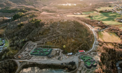
SaveAt Harstad Bike Park, you will have the opportunity to try it all – from exciting MTB trails to unique Freestyle and Skills Bike Parks. In 2021, the second phase of the project was completed, where the team of Velosolutions Scandinavia carried out impressive construction work for more than 3 months in the new, modern active recreation area.
 google parking directions
Links
This region uses the Uk/Euro style trail grading system.
Activities Click to view
- Mountain Bike
11 trails
- E-Bike
11 trails
- Hike
6 trails
Bike Park Details
- 6
- 2
- 2
- 1
Region Status
Open as of Jun 4, 2022- Uplift Type
- Magic Carpet
Stats
- Avg Trail Rating
- Trails (view details)
- 11
- Trails Mountain Bike
- 11
- Trails E-Bike
- 11
- Trails Hike
- 6
- Total Distance
- 2 miles
- Total Descent Distance
- 2,854 ft
- Total Descent
- 261 ft
- Total Vertical
- 102 ft
- Highest Trailhead
- 339 ft
- Reports
- 32
- Photos
- 1
- Ridden Counter
- 114
 Articles
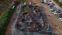
A Look at Velosolutions' Innovative New Bike Park in Norway
Dec 3, 2021 from pinkbike.com
The project includes what is currently the world's northernmost pump track(s).
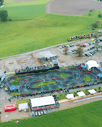
Popular Harstad Bike Park Mountain Biking Trails
Videos of Harstad Bike Park Mountain Bike
2:04 |
51 |
Apr 7, 2020
0:39 |
26 |
Jul 12, 2020
Recent Trail Reports
| status | trail | date | condition | info | user |
|---|---|---|---|---|---|
| Blue Flow | Jun 24, 2022 @ 7:34am Jun 24, 2022 | Ideal | Ahk506 | ||
| Blue Uphill | Jun 4, 2022 @ 11:46pm Jun 4, 2022 | Ideal | maristam HE | ||
| Green Family Bottom | Jun 4, 2022 @ 11:46pm Jun 4, 2022 | Ideal | maristam HE | ||
| Green Family Top | Jun 4, 2022 @ 11:46pm Jun 4, 2022 | Ideal | maristam HE | ||
| Green Uphill | Jun 4, 2022 @ 11:46pm Jun 4, 2022 | Ideal | maristam HE | ||
| Green Uphill Alternate Bottom | Jun 4, 2022 @ 11:46pm Jun 4, 2022 | Ideal | maristam HE | ||
| Green Uphill Alternate Middle | Jun 4, 2022 @ 11:46pm Jun 4, 2022 | Ideal | maristam HE | ||
| Green Uphill Alternate Top | Jun 4, 2022 @ 11:46pm Jun 4, 2022 | Ideal | maristam HE | ||
| Red Fun | Jun 4, 2022 @ 11:46pm Jun 4, 2022 | Ideal | maristam HE | ||
| Red Fun Alternate Top | Jun 4, 2022 @ 11:46pm Jun 4, 2022 | Ideal | maristam HE |
Activity Feed
| username | action | type | title | date | |
|---|---|---|---|---|---|
 | GyriFLn2mX | ridden | trail | Blue Flow and 2 more | Jul 1, 2022 @ 6:52am Jul 1, 2022 |
| Ahk506 | add | report | Blue Flow | Jun 24, 2022 @ 7:34am Jun 24, 2022 |
| Ahk506 | ridden | trail | Blue Flow | Jun 24, 2022 @ 7:33am Jun 24, 2022 |
 | BentEbeltoft | vote | trail | Black E-bike Up and 6 more | Jun 16, 2022 @ 6:05am Jun 16, 2022 |
| BentEbeltoft | ridden | trail | Blue Flow and 7 more | Jun 16, 2022 @ 4:10am Jun 16, 2022 |
Nearby Areas
| name | distance | ||||
|---|---|---|---|---|---|
| Folkeparken | 6 | 25 | 0.6 km | ||
| Kilhusåsen | 4 | 0.9 km | |||
| Hagebyen | 8 | 24 | 1.7 km | ||
| Sørsia | 5 | 23 | 2.6 km | ||
| Tovik | 5 | 12 | 12.2 km |
Bike & Skill Parks
| name | type | city | rating |
|---|---|---|---|
| Skill Park at Harstad Bike Park | skill park | Harstad |
Activity Type Stats
| activitytype | trails | distance | descent | descent distance | total vertical | rating | global rank | state rank | photos | reports | routes | ridelogs |
|---|---|---|---|---|---|---|---|---|---|---|---|---|
| Mountain Bike | 11 | 2 miles | 262 ft | 2,854 ft | 102 ft | #2,726 | #6 | 1 | 32 | 1 | ||
| E-Bike | 11 | 2 miles | 262 ft | 2,854 ft | 102 ft | #919 | #3 | 32 | ||||
| Hike | 6 | 3,661 ft | 20 ft | 528 ft | 102 ft | #183 | 31 |
- By maristam
 HE & contributors
 - Admins: sam-swag-g, maristam, HE
- #51105 - 604 views
- harstad bike park activity log | embed map of Harstad Bike Park mountain bike trails | harstad bike park mountain biking points of interest
Downloading of trail gps tracks in kml & gpx formats is enabled for Harstad Bike Park.
You must login to download files.