close
Trail Conditions
- Unknown
- Snow Groomed
- Snow Packed
- Snow Covered
- Snow Cover Inadequate
- Freeze/thaw Cycle
- Icy
- Prevalent Mud
- Wet
- Variable
- Ideal
- Dry
- Very Dry
Trail Flow (Ridden Direction)
Trailforks scans users ridelogs to determine the most popular direction each trail is ridden. A good flowing trail network will have most trails flowing in a single direction according to their intension.
The colour categories are based on what percentage of riders are riding a trail in its intended direction.
The colour categories are based on what percentage of riders are riding a trail in its intended direction.
- > 96%
- > 90%
- > 80%
- > 70%
- > 50%
- < 50%
- bi-directional trail
- no data
Trail Last Ridden
Trailforks scans ridelogs to determine the last time a trail was ridden.
- < 2 days
- < 1 week
- < 2 weeks
- < 1 month
- < 6 months
- > 6 months
Trail Ridden Direction
The intended direction a trail should be ridden.
- Downhill Only
- Downhill Primary
- Both Directions
- Uphill Primary
- Uphill Only
- One Direction
Contribute Details
Colors indicate trail is missing specified detail.
- Description
- Photos
- Description & Photos
- Videos
Trail Popularity ?
Trailforks scans ridelogs to determine which trails are ridden the most in the last 9 months.
Trails are compared with nearby trails in the same city region with a possible 25 colour shades.
Think of this as a heatmap, more rides = more kinetic energy = warmer colors.
- most popular
- popular
- less popular
- not popular
ATV/ORV/OHV Filter
Max Vehicle Width
inches
Radar Time
x
Activity Recordings
Trailforks users anonymized public ridelogs from the past 6 months.
- mountain biking recent
- mountain biking (>6 month)
- hiking (1 year)
- moto (1 year)
Activity Recordings
Trailforks users anonymized public skilogs from the past 12 months.
- Downhill Ski
- Backcountry Ski
- Nordic Ski
Jump Magnitude Heatmap
Heatmap of where riders jump on trails. Zoom in to see individual jumps, click circles to view jump details.
Trails Deemphasized
Trails are shown in grey.
Only show trails with NO bikes.
Save the current map location and zoom level as your default home location whenever this page is loaded.
Save
No description for Isaberg Mountain Resort has been added yet!
Login or register to submit one.
 google parking directions
google parking directionsThis region uses the Uk/Euro style trail grading system.
Activities Click to view
- Mountain Bike
66 trails
- E-Bike
21 trails
- Hike
36 trails
- Trail Running
36 trails
Bike Park Details
- 26
- 5
- 12
- 19
- 4
Region Status
Open as of 2 daysStats
- Avg Trail Rating
- Trails (view details)
- 67
- Trails Mountain Bike
- 66
- Trails E-Bike
- 21
- Trails Hike
- 36
- Trails Trail Running
- 36
- Total Distance
- 41 miles
- Total Descent Distance
- 17 miles
- Total Descent
- 5,053 ft
- Total Vertical
- 467 ft
- Highest Trailhead
- 995 ft
- Reports
- 323
- Photos
- 25
- Ridden Counter
- 20,928
 Articles
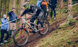
Race Report: Enduro Sweden Series Finale in Isaberg
Oct 15, 2019 from pinkbike.com
Isaberg offered up an abundance of steep, loamy stages for the final round.
Popular Isaberg Mountain Resort Mountain Biking Trails
Isaberg Mountain Resort Mountain Bike Routes
| title | rating | distance |
|---|---|---|
| BlueBerry | 9 miles | |
| Pink Lady | 6 miles | |
| SM XCO 2015 | 2 miles |
Photos of Isaberg Mountain Resort Mountain Bike
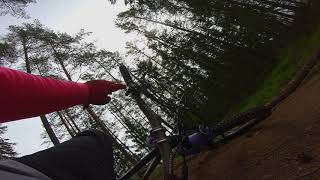
trail: Blue Berry
2 |
Jul 2, 2022 @ 12:49pm
Jul 2, 2022
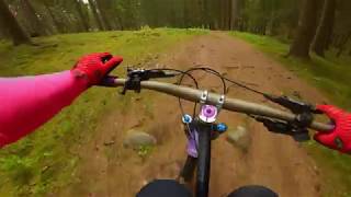
trail: Blue Berry
2 |
Jul 2, 2022 @ 12:49pm
Jul 2, 2022
trail: Blue Berry
8 |
Jul 2, 2022 @ 12:49pm
Jul 2, 2022
trail: Blue Berry
21 |
Oct 9, 2021 @ 7:01am
Oct 9, 2021
trail: Abborrasjövägen
7 |
Oct 9, 2021 @ 6:41am
Oct 9, 2021
trail: Blue Berry
19 |
Oct 9, 2021 @ 6:40am
Oct 9, 2021
trail: Blue Berry
32 |
Oct 9, 2021 @ 6:21am
Oct 9, 2021
trail: Pink Lady 1
27 |
Jun 20, 2021 @ 11:24am
Jun 20, 2021Videos of Isaberg Mountain Resort Mountain Bike

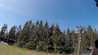
trail: Isabergsexpressen
33 |
Mar 1, 2021
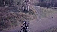
trail: Toppstigen
3:06 |
111 |
Sep 15, 2019
trail: Slash Specialsträcka
2:23 |
136 |
Dec 3, 2017

trail: Slash Specialsträcka
0:47 |
164 |
Apr 23, 2011
trail: Albatrossen
6:20 |
133 |
Aug 14, 2021 , Gislaved
trail: Slash
2:57 |
505 |
May 30, 2019 , Gislaved
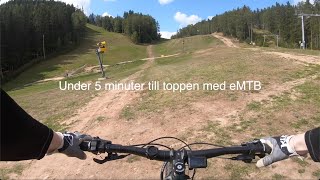
trail: Jättestigen
4:25 |
1063 |
May 30, 2019 , Gislaved
trail: No Mercy
1178 |
May 30, 2019 , Gislaved
Recent Trail Reports
| status | trail | date | condition | info | user |
|---|---|---|---|---|---|
| Blue Berry | Jul 4, 2022 @ 7:29am 2 days | Wet | Pettao | ||
| Nya Blue Berry Avslut | Jul 4, 2022 @ 7:29am 2 days | Variable | Pettao | ||
| The Nor Way | Jun 27, 2022 @ 8:19am Jun 27, 2022 | Very Dry | MTBambtenaar | ||
| Arenaplanen | Jun 12, 2022 @ 1:38am Jun 12, 2022 | Ideal | QuBaR | ||
| Högra Hopplinjen | Jun 12, 2022 @ 1:38am Jun 12, 2022 | Ideal | QuBaR | ||
| Stora Hoppet | Jun 12, 2022 @ 1:38am Jun 12, 2022 | Ideal | QuBaR | ||
| Mellan Hopplinjen | Jun 12, 2022 @ 1:38am Jun 12, 2022 | Ideal | QuBaR | ||
| Lätta Hoppleden | Jun 12, 2022 @ 1:38am Jun 12, 2022 | Ideal | QuBaR | ||
| XC-trail | Jun 12, 2022 @ 1:38am Jun 12, 2022 | Ideal | QuBaR | ||
| Isabergsexpressen | Oct 2, 2021 @ 3:41am Oct 2, 2021 | Variable | trailforks OMTBO |
Activity Feed
| username | action | type | title | date | |
|---|---|---|---|---|---|
 | Pettao | add | report | Blue Berry and 1 more | Jul 5, 2022 @ 11:32am 15 hours |
 | acroitoriu | ridden | trail | White Duck | Jul 4, 2022 @ 2:39am 2 days |
 | OrjanX | wishlist | route | Pink Lady | Jul 2, 2022 @ 1:09pm Jul 2, 2022 |
| acroitoriu | comment | route | Pink Lady | Jul 2, 2022 @ 12:52pm Jul 2, 2022 |
| acroitoriu | ridden | route | Pink Lady | Jul 2, 2022 @ 12:50pm Jul 2, 2022 |
Recent Comments
| username | type | title | comment | date | |
|---|---|---|---|---|---|
| trail | The GPX track is for less than 1k different... | Jul 2, 2022 @ 12:47pm Jul 2, 2022 | ||
| trail | Man kanske borde kunna göra detta i appen också? | Jun 21, 2022 @ 12:01pm Jun 21, 2022 | ||
| trail | Hej, använd också gärna rate-funktionen... | Jun 21, 2022 @ 11:25am Jun 21, 2022 | ||
| trail | Känns mer röd än blå | Jun 21, 2022 @ 4:23am Jun 21, 2022 | ||
| trail | Perfekt att cykla med sin 6-åring som vill ha... | Aug 4, 2021 @ 12:30pm Aug 4, 2021 |
Nearby Areas
| name | distance | ||||
|---|---|---|---|---|---|
| Grimsås | 3 | 2.8 km | |||
| Töllstorps fritidsområde | 9 | 2 | 7.4 km | ||
| Gislaved | 34 | 15 | 8.8 km | ||
| Tranemo | 3 | 10.1 km | |||
| Anderstorp med omnejd | 27 | 21 | 10.5 km |
Local Badges
-

Completionist0 awarded
Pinkbike Articles
Oct 14, 2019
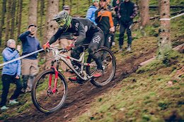 Race Report: Enduro Sweden Series Finale in Isaberg
Isaberg offered up an abundance of steep, loamy stages for the final round.
Activity Type Stats
| activitytype | trails | distance | descent | descent distance | total vertical | rating | global rank | state rank | photos | reports | routes | ridelogs |
|---|---|---|---|---|---|---|---|---|---|---|---|---|
| Mountain Bike | 66 | 40 miles | 5,043 ft | 17 miles | 466 ft | #467 | #10 | 25 | 319 | 3 | 6,178 | |
| E-Bike | 21 | 17 miles | 1,946 ft | 7 miles | 466 ft | #333 | #1 | 253 | 3 | 37 | ||
| Hike | 36 | 17 miles | 1,388 ft | 7 miles | 456 ft | #3,303 | #76 | 255 | 2 | 45 | ||
| Trail Running | 36 | 18 miles | 1,385 ft | 7 miles | 456 ft | #3,007 | #68 | 255 | 2 | 76 |
- By jbella VSC & contributors
- Admins: IMR, kalle5987
- #14314 - 27,847 views
- isaberg mountain resort activity log | embed map of Isaberg Mountain Resort mountain bike trails | isaberg mountain resort mountain biking points of interest polygons
-
- subscribe
- 3d map
Downloading of trail gps tracks in kml & gpx formats is enabled for Isaberg Mountain Resort.
You must login to download files.