close
Trail Conditions
- Unknown
- Snow Groomed
- Snow Packed
- Snow Covered
- Snow Cover Inadequate
- Freeze/thaw Cycle
- Icy
- Prevalent Mud
- Wet
- Variable
- Ideal
- Dry
- Very Dry
Trail Flow (Ridden Direction)
Trailforks scans users ridelogs to determine the most popular direction each trail is ridden. A good flowing trail network will have most trails flowing in a single direction according to their intension.
The colour categories are based on what percentage of riders are riding a trail in its intended direction.
The colour categories are based on what percentage of riders are riding a trail in its intended direction.
- > 96%
- > 90%
- > 80%
- > 70%
- > 50%
- < 50%
- bi-directional trail
- no data
Trail Last Ridden
Trailforks scans ridelogs to determine the last time a trail was ridden.
- < 2 days
- < 1 week
- < 2 weeks
- < 1 month
- < 6 months
- > 6 months
Trail Ridden Direction
The intended direction a trail should be ridden.
- Downhill Only
- Downhill Primary
- Both Directions
- Uphill Primary
- Uphill Only
- One Direction
Contribute Details
Colors indicate trail is missing specified detail.
- Description
- Photos
- Description & Photos
- Videos
Trail Popularity ?
Trailforks scans ridelogs to determine which trails are ridden the most in the last 9 months.
Trails are compared with nearby trails in the same city region with a possible 25 colour shades.
Think of this as a heatmap, more rides = more kinetic energy = warmer colors.
- most popular
- popular
- less popular
- not popular
ATV/ORV/OHV Filter
Max Vehicle Width
inches
Radar Time
x
Activity Recordings
Trailforks users anonymized public ridelogs from the past 6 months.
- mountain biking recent
- mountain biking (>6 month)
- hiking (1 year)
- moto (1 year)
Activity Recordings
Trailforks users anonymized public skilogs from the past 12 months.
- Downhill Ski
- Backcountry Ski
- Nordic Ski
Jump Magnitude Heatmap
Heatmap of where riders jump on trails. Zoom in to see individual jumps, click circles to view jump details.
Trails Deemphasized
Trails are shown in grey.
Only show trails with NO bikes.
Save the current map location and zoom level as your default home location whenever this page is loaded.
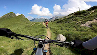
SaveThree very natural trails at the Kitzsteinhorn.
source: Kitzsteinhorn
Primary Trail Type: All-Mountain & Downhill
 google parking directions
 Access Info:
Bottom station gondola "Gletscherjet/Panoramabahn"
Links
This region uses the Uk/Euro style trail grading system.
Activities Click to view
- Mountain Bike
4 trails
- E-Bike
4 trails
- Hike
1 trails
- Trail Running
1 trails
Bike Park Details
- 1
- 1
- 2
Region Status
Caution as of Jun 25, 2021- Day Ticket
- 41 EUR
- Uplift Type
- Gondola
Stats
- Avg Trail Rating
- Trails (view details)
- 4
- Trails Mountain Bike
- 4
- Trails E-Bike
- 4
- Trails Hike
- 1
- Trails Trail Running
- 1
- Total Distance
- 21 miles
- Total Descent Distance
- 9 miles
- Total Descent
- 8,031 ft
- Total Vertical
- 5,451 ft
- Highest Trailhead
- 7,973 ft
- Reports
- 18
- Photos
- 7
- Ridden Counter
- 135
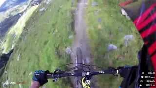
Popular Kitzsteinhorn Mountain Biking Trails
| status | title | difficulty | rating |
|---|---|---|---|
| Geißstein Trail | |||
| Wüstlau Trail | |||
| Bachler Trail | |||
| Kaprun Uphill to Alpincenter |
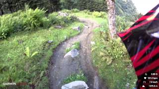
Photos of Kitzsteinhorn Mountain Bike
trail: Wüstlau Trail
105 |
Jun 25, 2021 @ 3:02am
Jun 25, 2021
trail: Wüstlau Trail
179 |
Jul 28, 2019 @ 9:44pm
Jul 28, 2019
trail: Wüstlau Trail
218 |
Jul 28, 2019 @ 9:44pm
Jul 28, 2019Videos of Kitzsteinhorn Mountain Bike
trail: Geißstein Trail
6:45 |
392 |
Aug 13, 2020
trail: Geißstein Trail
1000 |
Mar 21, 2016 , Kaprun
trail: Wüstlau Trail
1518 |
Mar 21, 2016 , Kaprun
Recent Trail Reports
| status | trail | date | condition | info | user |
|---|---|---|---|---|---|
| Bachler Trail | Sep 25, 2021 @ 2:47pm Sep 25, 2021 | Variable | acyclist | ||
| Geißstein Trail | Aug 21, 2021 @ 1:14pm Aug 21, 2021 | Variable | ChrisPosch | ||
| Wüstlau Trail | Aug 21, 2021 @ 1:10pm Aug 21, 2021 | Variable | ChrisPosch | ||
| Kaprun Uphill to Alpincenter | Dec 19, 2019 @ 11:08pm Dec 19, 2019 | Snow Covered | kyleluvsdh |
Activity Feed
| username | action | type | title | date | |
|---|---|---|---|---|---|
 | Msteine1 | wishlist | trail | Geißstein Trail | Jun 23, 2022 @ 1:50pm Jun 23, 2022 |
 | muerte | ridden | trail | Bachler Trail and 2 more | Apr 17, 2022 @ 9:00am Apr 17, 2022 |
| All-Star | ridden | trail | Kaprun Uphill to Alpincenter | Apr 3, 2022 @ 12:00am Apr 3, 2022 |
| Slin3 | wishlist | trail | Kaprun Uphill to Alpincenter and 2 more | Mar 31, 2022 @ 12:47am Mar 31, 2022 |
| C4quattro | wishlist | trail | Bachler Trail | Feb 4, 2022 @ 11:22am Feb 4, 2022 |
Recent Comments
| username | type | title | comment | date | |
|---|---|---|---|---|---|
| trail | Nicely traii that is a lot less technical than... | Aug 17, 2021 @ 7:05am Aug 17, 2021 | ||
| trail | Beautiful views, technical descent, "natural... | Aug 17, 2021 @ 7:02am Aug 17, 2021 | ||
 | trail | trail momentan gesperrt - wurde durch die... | Jul 22, 2021 @ 11:21pm Jul 22, 2021 | ||
 | trail | Nicht völlig gesperrt – nur fürs heurige... | Oct 5, 2020 @ 1:38am Oct 5, 2020 | ||
| trail | Nicht völlig gesperrt – nur fürs heurige... | Oct 5, 2020 @ 1:37am Oct 5, 2020 |
Nearby Areas
| name | distance | ||||
|---|---|---|---|---|---|
| Bike-Circus - Saalbach Hinterglemm | 6 | 11.9 km | |||
| The epic Bikepark Leogang | 2 | 2 | 13.6 km | ||
| Großglockner Resort | 1 | 1 | 15.7 km | ||
| Bike Area Streuböden | 1 | 2 | 18.3 km | ||
| KitzSki Biketrails | 2 | 22.5 km |
Activity Type Stats
| activitytype | trails | distance | descent | descent distance | total vertical | rating | global rank | state rank | photos | reports | routes | ridelogs |
|---|---|---|---|---|---|---|---|---|---|---|---|---|
| Mountain Bike | 4 | 21 miles | 8,031 ft | 9 miles | 5,453 ft | #3,982 | #29 | 7 | 18 | 105 | ||
| E-Bike | 4 | 21 miles | 8,031 ft | 9 miles | 5,453 ft | #1,503 | #23 | 14 | 5 | |||
| Hike | 1 | 14 miles | 1,148 ft | 2 miles | 5,453 ft | #39 | 5 | 23 | ||||
| Trail Running | 1 | 14 miles | 1,148 ft | 2 miles | 5,453 ft | #40 | 5 |
- By lines
 TRAILFORKS & contributors
 - Admins: apply
- #13525 - 3,705 views
- kitzsteinhorn activity log | embed map of Kitzsteinhorn mountain bike trails | kitzsteinhorn mountain biking points of interest
-
- subscribe
- 3d map
Downloading of trail gps tracks in kml & gpx formats is enabled for Kitzsteinhorn.
You must login to download files.