close
Trail Conditions
- Unknown
- Snow Groomed
- Snow Packed
- Snow Covered
- Snow Cover Inadequate
- Freeze/thaw Cycle
- Icy
- Prevalent Mud
- Wet
- Variable
- Ideal
- Dry
- Very Dry
Trail Flow (Ridden Direction)
Trailforks scans users ridelogs to determine the most popular direction each trail is ridden. A good flowing trail network will have most trails flowing in a single direction according to their intension.
The colour categories are based on what percentage of riders are riding a trail in its intended direction.
The colour categories are based on what percentage of riders are riding a trail in its intended direction.
- > 96%
- > 90%
- > 80%
- > 70%
- > 50%
- < 50%
- bi-directional trail
- no data
Trail Last Ridden
Trailforks scans ridelogs to determine the last time a trail was ridden.
- < 2 days
- < 1 week
- < 2 weeks
- < 1 month
- < 6 months
- > 6 months
Trail Ridden Direction
The intended direction a trail should be ridden.
- Downhill Only
- Downhill Primary
- Both Directions
- Uphill Primary
- Uphill Only
- One Direction
Contribute Details
Colors indicate trail is missing specified detail.
- Description
- Photos
- Description & Photos
- Videos
Trail Popularity ?
Trailforks scans ridelogs to determine which trails are ridden the most in the last 9 months.
Trails are compared with nearby trails in the same city region with a possible 25 colour shades.
Think of this as a heatmap, more rides = more kinetic energy = warmer colors.
- most popular
- popular
- less popular
- not popular
ATV/ORV/OHV Filter
Max Vehicle Width
inches
Radar Time
x
Activity Recordings
Trailforks users anonymized public ridelogs from the past 6 months.
- mountain biking recent
- mountain biking (>6 month)
- hiking (1 year)
- moto (1 year)
Activity Recordings
Trailforks users anonymized public skilogs from the past 12 months.
- Downhill Ski
- Backcountry Ski
- Nordic Ski
Jump Magnitude Heatmap
Heatmap of where riders jump on trails. Zoom in to see individual jumps, click circles to view jump details.
Trails Deemphasized
Trails are shown in grey.
Only show trails with NO bikes.
Save the current map location and zoom level as your default home location whenever this page is loaded.
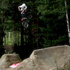
SaveSmall and cozy bikepark in the heart of Porvoo. Nice combination of natural and machine built trails and jumps.
source: Kokonniemi Bike Park
Primary Trail Type: All-Mountain & Downhill
eBikes Allowed:
Yes
Land Status: Ski Resort
Disclaimer:
Note about trail difficulty: Local trail difficult markings aren't according international standard. Their red is black, and black is double black!
Links
This region uses the Uk/Euro style trail grading system.
Activities Click to view
- Mountain Bike
10 trails
- E-Bike
2 trails
- Hike
0 trails
- Trail Running
0 trails
Bike Park Details
- 3
- 3
- 2
Region Status
Open as of May 9, 2020- Day Ticket
- 25 EUR
- Uplift Type
- T-Bar
- Season start
- May 1
- Season end
- Sep 29
Stats
- Avg Trail Rating
- Trails (view details)
- 10
- Trails Mountain Bike
- 10
- Trails E-Bike
- 2
- Total Distance
- 2 miles
- Total Descent
- 1,612 ft
- Total Vertical
- 177 ft
- Highest Trailhead
- 186 ft
- Reports
- 25
- Ridden Counter
- 331
Popular Kokonniemi Bike Park Mountain Biking Trails
| status | title | difficulty | rating |
|---|---|---|---|
| Start Me Up | |||
| Jail Brake | |||
| Sweet Dreams | |||
| More is More | |||
| Wild Child | |||
| Malmsteen | |||
| Keiner Boogie | |||
| Sixx |
Recent Trail Reports
| status | trail | date | condition | info | user |
|---|---|---|---|---|---|
| Malmsteen | Jul 2, 2020 @ 9:12am Jul 2, 2020 | Variable | sokantoivo | ||
| Wham w | Jul 2, 2020 @ 9:12am Jul 2, 2020 | Variable | sokantoivo | ||
| More is More | Jul 2, 2020 @ 9:12am Jul 2, 2020 | Ideal | sokantoivo | ||
| Wild Child | Jul 2, 2020 @ 9:12am Jul 2, 2020 | Variable | sokantoivo | ||
| Jail Brake | Jul 2, 2020 @ 9:12am Jul 2, 2020 | Variable | sokantoivo | ||
| Keiner Boogie | Jul 2, 2020 @ 9:12am Jul 2, 2020 | Ideal | sokantoivo | ||
| Skid Row w | Jul 2, 2020 @ 9:12am Jul 2, 2020 | Variable | sokantoivo | ||
| Start Me Up | Jul 2, 2020 @ 9:12am Jul 2, 2020 | Ideal | sokantoivo | ||
| Sweet Dreams | Jul 2, 2020 @ 9:12am Jul 2, 2020 | Ideal | sokantoivo | ||
| Sixx | May 9, 2020 @ 2:05am May 9, 2020 | Dry | Thethent |
Activity Feed
| username | action | type | title | date | |
|---|---|---|---|---|---|
 | markholloway | update | trail | Sweet Dreams | Sep 6, 2021 @ 2:40pm Sep 6, 2021 |
 | sokantoivo | add | report | Kokonniemi Bike Park #6.5 and 8 more | Jul 2, 2020 @ 11:27pm Jul 2, 2020 |
 | lkar | wishlist | trail | Start Me Up and 2 more | Jun 8, 2020 @ 2:04pm Jun 8, 2020 |
| lkar | ridden | trail | Start Me Up and 2 more | Jun 8, 2020 @ 2:04pm Jun 8, 2020 |
| Jaybeberg | ridden | trail | Kokonniemi Bike Park #1 and 1 more | May 17, 2020 @ 11:04am May 17, 2020 |
Nearby Areas
| name | distance | ||||
|---|---|---|---|---|---|
| Kivisniemi | 4 | 1 | 9.7 km | ||
| Hyötinmäki | 4 | 10.9 km | |||
| Söderkulla | 9 | 12.8 km |
Activity Type Stats
| activitytype | trails | distance | descent | descent distance | total vertical | rating | global rank | state rank | photos | reports | routes | ridelogs |
|---|---|---|---|---|---|---|---|---|---|---|---|---|
| Mountain Bike | 10 | 2 miles | 1,611 ft | 2 miles | 177 ft | #3,594 | #1 | 25 | 477 | |||
| E-Bike | 2 | 2,467 ft | 295 ft | 2,159 ft | 154 ft | #2,554 | #10 | 22 | 2 |
- By brenthillier
 NSMBA TRAILFORKS & contributors
 - Admins: apply
- #12774 - 3,817 views
- kokonniemi bike park activity log | embed map of Kokonniemi Bike Park mountain bike trails |
-
- subscribe
- 3d map
Downloading of trail gps tracks in kml & gpx formats is enabled for Kokonniemi Bike Park.
You must login to download files.