close
Trail Conditions
- Unknown
- Snow Groomed
- Snow Packed
- Snow Covered
- Snow Cover Inadequate
- Freeze/thaw Cycle
- Icy
- Prevalent Mud
- Wet
- Variable
- Ideal
- Dry
- Very Dry
Trail Flow (Ridden Direction)
Trailforks scans users ridelogs to determine the most popular direction each trail is ridden. A good flowing trail network will have most trails flowing in a single direction according to their intension.
The colour categories are based on what percentage of riders are riding a trail in its intended direction.
The colour categories are based on what percentage of riders are riding a trail in its intended direction.
- > 96%
- > 90%
- > 80%
- > 70%
- > 50%
- < 50%
- bi-directional trail
- no data
Trail Last Ridden
Trailforks scans ridelogs to determine the last time a trail was ridden.
- < 2 days
- < 1 week
- < 2 weeks
- < 1 month
- < 6 months
- > 6 months
Trail Ridden Direction
The intended direction a trail should be ridden.
- Downhill Only
- Downhill Primary
- Both Directions
- Uphill Primary
- Uphill Only
- One Direction
Contribute Details
Colors indicate trail is missing specified detail.
- Description
- Photos
- Description & Photos
- Videos
Trail Popularity ?
Trailforks scans ridelogs to determine which trails are ridden the most in the last 9 months.
Trails are compared with nearby trails in the same city region with a possible 25 colour shades.
Think of this as a heatmap, more rides = more kinetic energy = warmer colors.
- most popular
- popular
- less popular
- not popular
ATV/ORV/OHV Filter
Max Vehicle Width
inches
Radar Time
x
Activity Recordings
Trailforks users anonymized public ridelogs from the past 6 months.
- mountain biking recent
- mountain biking (>6 month)
- hiking (1 year)
- moto (1 year)
Activity Recordings
Trailforks users anonymized public skilogs from the past 12 months.
- Downhill Ski
- Backcountry Ski
- Nordic Ski
Jump Magnitude Heatmap
Heatmap of where riders jump on trails. Zoom in to see individual jumps, click circles to view jump details.
Trails Deemphasized
Trails are shown in grey.
Only show trails with NO bikes.
Save the current map location and zoom level as your default home location whenever this page is loaded.
Save
No description for Kope has been added yet!
Login or register to submit one.
Primary Trail Type: All-Mountain & Downhill
eBikes Allowed:
Yes
Shuttleable: YES
Land Status: Ski Resort
Links
This region uses the Uk/Euro style trail grading system.
Activities Click to view
- Mountain Bike
1 trails
- Hike
0 trails
- Trail Running
0 trails
- Snowmobile
0 trails
- Snowshoe
0 trails
- Downhill Ski
0 trails
- Backcountry Ski
0 trails
- Nordic Ski
0 trails
Region Details
- 1
Region Status
Caution as of Aug 22, 2021- Day Ticket
- 14 EUR
- Uplift Type
- Chair Lift
Stats
- Trails (view details)
- 1
- Trails Mountain Bike
- 1
- Total Distance
- 4,905 ft
- Total Descent Distance
- 4,573 ft
- Total Descent
- 489 ft
- Total Vertical
- 485 ft
- Highest Trailhead
- 5,020 ft
- Reports
- 8
- Photos
- 13
- Ridden Counter
- 48
Popular Kope Mountain Biking Trails
| status | title | difficulty | rating |
|---|---|---|---|
| Flow |
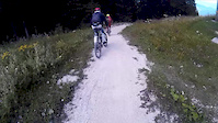
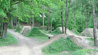
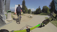
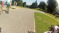
Photos of Kope Mountain Bike
trail: Flow
88 |
Jun 16, 2017 @ 3:16am
Jun 16, 2017
trail: Flow
209 |
Aug 14, 2015 @ 9:46am
Aug 14, 2015
trail: Flow
597 | | 1 comments
Nov 28, 2013 @ 6:55am
Nov 28, 2013
trail: Flow
438 |
Nov 28, 2013 @ 6:54am
Nov 28, 2013
trail: Flow
87 |
Sep 4, 2013 @ 2:04pm
Sep 4, 2013
trail: Flow
72 |
Jul 14, 2013 @ 2:11pm
Jul 14, 2013
trail: Flow
74 |
Jul 14, 2013 @ 2:10pm
Jul 14, 2013
trail: Flow
88 |
Jul 14, 2013 @ 2:09pm
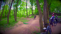
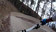
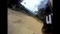
Jul 14, 2013Videos of Kope Mountain Bike
trail: Flow
4:18 |
69 |
Aug 19, 2016
trail: Flow
0:16 |
151 |
Jun 4, 2016
trail: Flow
0:06 |
67 |
Jun 10, 2015
trail: Flow
3:37 |
338 |
Oct 22, 2014
trail: Flow
8:55 |
184 |
May 29, 2014

trail: Flow
3:15 |
203 |
May 25, 2014
trail: Flow
1:00 |
240 |
Jan 8, 2014
trail: Flow
10:54 |
118 |
Nov 22, 2012
Recent Trail Reports
| status | trail | date | condition | info | user |
|---|---|---|---|---|---|
| Flow | Aug 21, 2021 @ 6:02am Aug 21, 2021 | Very Dry | Gugi79 |
Activity Feed
| username | action | type | title | date | |
|---|---|---|---|---|---|
 | nasumman | ridden | trail | Flow | Jun 25, 2022 @ 3:57am Jun 25, 2022 |
 | ZiggyAMG | ridden | trail | Flow | Jun 19, 2022 @ 2:27pm Jun 19, 2022 |
| Pitboss666 | ridden | trail | Flow | Aug 23, 2021 @ 2:04am Aug 23, 2021 |
| Pitboss666 | wishlist | trail | Flow | Aug 23, 2021 @ 2:04am Aug 23, 2021 |
| Gugi79 | add | report | Flow | Aug 22, 2021 @ 6:19am Aug 22, 2021 |
Nearby Areas
| name | distance | ||||
|---|---|---|---|---|---|
| Bike Park Rogla | 1 | 2 | 7 km | ||
| Lovrenc Na Pohorju | 3 | 7.6 km | |||
| Vodemla Trails | 9 km | ||||
| Uršlja gora | 11 km | ||||
| Bike Park Poseka | 1 | 1 | 11.9 km |
- By karampampoli
 & contributors
 - Admins: VjekoslavKrsanac, zocknroll, ridgelinetrails
- #21175 - 2,896 views
- kope activity log | embed map of Kope mountain bike trails |
Downloading of trail gps tracks in kml & gpx formats is enabled for Kope.
You must login to download files.