close
Trail Conditions
- Unknown
- Snow Groomed
- Snow Packed
- Snow Covered
- Snow Cover Inadequate
- Freeze/thaw Cycle
- Icy
- Prevalent Mud
- Wet
- Variable
- Ideal
- Dry
- Very Dry
Trail Flow (Ridden Direction)
Trailforks scans users ridelogs to determine the most popular direction each trail is ridden. A good flowing trail network will have most trails flowing in a single direction according to their intension.
The colour categories are based on what percentage of riders are riding a trail in its intended direction.
The colour categories are based on what percentage of riders are riding a trail in its intended direction.
- > 96%
- > 90%
- > 80%
- > 70%
- > 50%
- < 50%
- bi-directional trail
- no data
Trail Last Ridden
Trailforks scans ridelogs to determine the last time a trail was ridden.
- < 2 days
- < 1 week
- < 2 weeks
- < 1 month
- < 6 months
- > 6 months
Trail Ridden Direction
The intended direction a trail should be ridden.
- Downhill Only
- Downhill Primary
- Both Directions
- Uphill Primary
- Uphill Only
- One Direction
Contribute Details
Colors indicate trail is missing specified detail.
- Description
- Photos
- Description & Photos
- Videos
Trail Popularity ?
Trailforks scans ridelogs to determine which trails are ridden the most in the last 9 months.
Trails are compared with nearby trails in the same city region with a possible 25 colour shades.
Think of this as a heatmap, more rides = more kinetic energy = warmer colors.
- most popular
- popular
- less popular
- not popular
ATV/ORV/OHV Filter
Max Vehicle Width
inches
Radar Time
x
Activity Recordings
Trailforks users anonymized public ridelogs from the past 6 months.
- mountain biking recent
- mountain biking (>6 month)
- hiking (1 year)
- moto (1 year)
Activity Recordings
Trailforks users anonymized public skilogs from the past 12 months.
- Downhill Ski
- Backcountry Ski
- Nordic Ski
Jump Magnitude Heatmap
Heatmap of where riders jump on trails. Zoom in to see individual jumps, click circles to view jump details.
Trails Deemphasized
Trails are shown in grey.
Only show trails with NO bikes.
Save the current map location and zoom level as your default home location whenever this page is loaded.
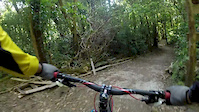
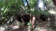
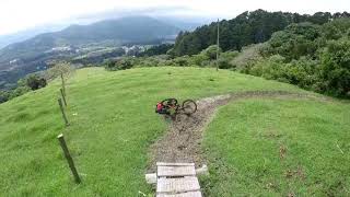
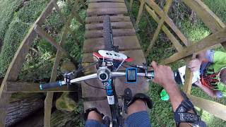
SaveMountain bike park in Ochomogo, Cartago, Costa Rica. The park offers a great combination of single track trails for all-mountain, enduro and downhill riding.
Primary Trail Type: All-Mountain & Downhill
Shuttleable: YES
Land Status: Private Property
 google parking directions
Links
Activities Click to view
- Mountain Bike
37 trails
- E-Bike
31 trails
- Hike
36 trails
- Trail Running
35 trails
Bike Park Details
- 3
- 12
- 12
- 6
- 4
Region Status
Open as of Jun 25, 2022- Day Ticket
- $8 USD
- Uplift Type
- Shuttle
Stats
- Avg Trail Rating
- Trails (view details)
- 39
- Trails Mountain Bike
- 37
- Trails E-Bike
- 31
- Trails Hike
- 36
- Trails Trail Running
- 35
- Total Distance
- 12 miles
- Total Descent
- 4,929 ft
- Total Vertical
- 1,002 ft
- Highest Trailhead
- 6,192 ft
- Reports
- 553
- Photos
- 53
- Ridden Counter
- 3,079
Popular La Angelina Mountain Biking Trails
La Angelina Mountain Bike Routes
| title | rating | distance |
|---|---|---|
| Ruta Azul-Vuelta Larga | 5 miles | |
| Ruta Morada - Vuelta Intermedia | 4 miles | |
| Ruta Verde-Vuelta Primerizos | 2 miles | |
| Ruta Amarilla-Caminata Corta | 3 miles | |
| race | 6 miles |
Photos of La Angelina Mountain Bike
trail: Brincos de La P
30 |
Dec 18, 2021 @ 8:24pm
Dec 18, 2021
trail: E.N.U.
53 |
Jun 6, 2020 @ 3:51pm
Jun 6, 2020
trail: E.N.U.
59 |
Jun 6, 2020 @ 3:51pm
Jun 6, 2020
trail: Los Abitos
68 |
Sep 30, 2019 @ 8:14am
Sep 30, 2019
trail: Los Abitos
66 |
Sep 30, 2019 @ 8:13am
Sep 30, 2019
trail: Los Abitos
83 |
Sep 30, 2019 @ 6:24am
Sep 30, 2019
trail: Calle Ancha
45 |
Feb 8, 2019 @ 6:37pm
Feb 8, 2019
trail: Calle Ancha
38 |
Sep 1, 2018 @ 11:46am
Sep 1, 2018Videos of La Angelina Mountain Bike
trail: Enduro
10:58 |
478 |
Feb 8, 2014
trail: Enduro
9:47 |
303 |
Feb 7, 2014

trail: Principiantes
6:46 |
474 |
May 2, 2011
trail: Los Primos
0:06 |
332 |
Sep 24, 2018 , My City
trail: Tio Teto
6:15 |
320 |
Sep 24, 2018 , My City

trail: Checho
6:01 |
355 |
Sep 24, 2018 , My City

trail: Zig Zag
3:41 |
259 |
Sep 24, 2018 , My City

trail: La Guerra
3:41 |
189 |
Sep 24, 2018 , My City
Recent Trail Reports
| status | trail | date | condition | info | user |
|---|---|---|---|---|---|
| Las Raíces | Jun 25, 2022 @ 9:21am Jun 25, 2022 | Variable | V1c70r | ||
| El Limón | Jun 25, 2022 @ 9:21am Jun 25, 2022 | Variable | V1c70r | ||
| Gabs | Jun 25, 2022 @ 9:21am Jun 25, 2022 | Wet | V1c70r | ||
| Porton-Tajo | Jun 18, 2022 @ 9:05am Jun 18, 2022 | Variable | Mario-84 | ||
| Recta de Entrada | Jun 18, 2022 @ 9:05am Jun 18, 2022 | Ideal | Mario-84 | ||
| La Vereda | Jun 4, 2022 @ 8:27am Jun 4, 2022 | Variable | V1c70r | ||
| Los Coyotes | Jun 4, 2022 @ 8:27am Jun 4, 2022 | Variable | V1c70r | ||
| Brincos de La P | Jun 4, 2022 @ 8:27am Jun 4, 2022 | Ideal | V1c70r | ||
| Los Abitos | May 28, 2022 @ 9:54am May 28, 2022 | Variable | V1c70r | ||
| Los Porós | May 28, 2022 @ 9:54am May 28, 2022 | Variable | V1c70r |
Activity Feed
| username | action | type | title | date | |
|---|---|---|---|---|---|
 | V1c70r | add | report | Las Raíces and 2 more | Jun 25, 2022 @ 2:16pm Jun 25, 2022 |
 | Mario-84 | add | report | Porton-Tajo and 1 more | Jun 19, 2022 @ 7:35am Jun 19, 2022 |
| V1c70r | add | report | La Vereda and 2 more | Jun 6, 2022 @ 5:52am Jun 6, 2022 |
| Sotochuz | add | report | Los Coyotes | May 29, 2022 @ 11:17am May 29, 2022 |
| Sotochuz | ridden | trail | Los Coyotes and 2 more | May 29, 2022 @ 11:16am May 29, 2022 |
Recent Comments
| username | type | title | comment | date | |
|---|---|---|---|---|---|
| trail | 9 días | Nov 3, 2019 @ 8:29am Nov 3, 2019 |
Nearby Areas
| name | distance | ||||
|---|---|---|---|---|---|
| Parque De La Libertad | 1 | 6 km | |||
| El Iral Bosque Nuboso | 1 | 1 | 6.1 km | ||
| Destinos La Lucha | 12.6 km | ||||
| Adventure Park | 4 | 2 | 16 km | ||
| Rio Perdido | 17.5 km |
Local Badges
-

Completionist3 awarded
Bike & Skill Parks
| name | type | city | rating |
|---|---|---|---|
| Pump Track La Angelina | skill park |
Upcoming Local Events
Local Trail Supporters
- Juan Onetto
Local Trail Supporters
- Juan Onetto
Activity Type Stats
| activitytype | trails | distance | descent | descent distance | total vertical | rating | global rank | state rank | photos | reports | routes | ridelogs |
|---|---|---|---|---|---|---|---|---|---|---|---|---|
| Mountain Bike | 37 | 11 miles | 4,311 ft | 6 miles | 1,001 ft | #2,326 | #2 | 35 | 553 | 5 | 1,257 | |
| E-Bike | 31 | 10 miles | 3,711 ft | 5 miles | 965 ft | #1,105 | #1 | 552 | 3 | 53 | ||
| Hike | 36 | 11 miles | 4,452 ft | 6 miles | 1,001 ft | #2,495 | #2 | 17 | 553 | 4 | 65 | |
| Trail Running | 35 | 11 miles | 4,058 ft | 5 miles | 1,001 ft | #2,563 | #3 | 1 | 553 | 4 | 40 |
- By castpack
 LSC & contributors
 - Admins: castpack, castpack
- #7274 - 16,710 views
- la angelina activity log | embed map of La Angelina mountain bike trails | la angelina mountain biking points of interest
-
- subscribe
- 3d map
Downloading of trail gps tracks in kml & gpx formats is enabled for La Angelina.
You must login to download files.