close
Trail Conditions
- Unknown
- Snow Groomed
- Snow Packed
- Snow Covered
- Snow Cover Inadequate
- Freeze/thaw Cycle
- Icy
- Prevalent Mud
- Wet
- Variable
- Ideal
- Dry
- Very Dry
Trail Flow (Ridden Direction)
Trailforks scans users ridelogs to determine the most popular direction each trail is ridden. A good flowing trail network will have most trails flowing in a single direction according to their intension.
The colour categories are based on what percentage of riders are riding a trail in its intended direction.
The colour categories are based on what percentage of riders are riding a trail in its intended direction.
- > 96%
- > 90%
- > 80%
- > 70%
- > 50%
- < 50%
- bi-directional trail
- no data
Trail Last Ridden
Trailforks scans ridelogs to determine the last time a trail was ridden.
- < 2 days
- < 1 week
- < 2 weeks
- < 1 month
- < 6 months
- > 6 months
Trail Ridden Direction
The intended direction a trail should be ridden.
- Downhill Only
- Downhill Primary
- Both Directions
- Uphill Primary
- Uphill Only
- One Direction
Contribute Details
Colors indicate trail is missing specified detail.
- Description
- Photos
- Description & Photos
- Videos
Trail Popularity ?
Trailforks scans ridelogs to determine which trails are ridden the most in the last 9 months.
Trails are compared with nearby trails in the same city region with a possible 25 colour shades.
Think of this as a heatmap, more rides = more kinetic energy = warmer colors.
- most popular
- popular
- less popular
- not popular
ATV/ORV/OHV Filter
Max Vehicle Width
inches
Radar Time
x
Activity Recordings
Trailforks users anonymized public ridelogs from the past 6 months.
- mountain biking recent
- mountain biking (>6 month)
- hiking (1 year)
- moto (1 year)
Activity Recordings
Trailforks users anonymized public skilogs from the past 12 months.
- Downhill Ski
- Backcountry Ski
- Nordic Ski
Jump Magnitude Heatmap
Heatmap of where riders jump on trails. Zoom in to see individual jumps, click circles to view jump details.
Trails Deemphasized
Trails are shown in grey.
Only show trails with NO bikes.
Save the current map location and zoom level as your default home location whenever this page is loaded.
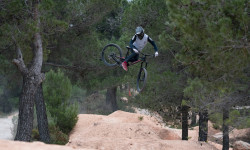
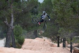
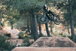
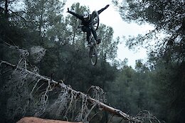
SaveLa Fenasosa is a private property located in the Nature Park of Sierra Mariola in the province of Alicante, with rides distributed within its 1000 acres of land and marked by different colours depending on the levels of difficulty. More than 20 km. of rides of Downhill, Freeride, Wood Park, Four Cross,... rides of different types and for all levels, where you’ll find all kind of tracks from high difficulty only for experts to very funny and smooth ones for all riders.
OPEN EVERY WEEKEND OF THE YEAR, EXCEPT IN AUGUST
The Mediterranean climate gives us many hours of sunshine each day. Why not take advantage of them to enjoy yourselves on two wheels, surrounded by nature?
OPEN EVERY WEEKEND OF THE YEAR, EXCEPT IN AUGUST
The Mediterranean climate gives us many hours of sunshine each day. Why not take advantage of them to enjoy yourselves on two wheels, surrounded by nature?
source: bikepark website
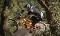
Primary Trail Type: All-Mountain & Downhill
Shuttleable: YES
Land Status: Private Property
Access Info:
La Fenasosa Bike Park is located in the Alicante town of Banyeres de Mariola, near to Alcoi, Ontinyent and Villena.
GPS Coordinates: 38º 40' 50'' N - 0º 38' 20'' W
Contact Phone: 607 303 570
GPS Coordinates: 38º 40' 50'' N - 0º 38' 20'' W
Contact Phone: 607 303 570
Links
This region uses the Uk/Euro style trail grading system.
Activities Click to view
- Mountain Bike
9 trails
- E-Bike
9 trails
Bike Park Details
- 2
- 3
- 2
- 2
Region Status
Open as of Nov 7, 2021- Day Ticket
- 16 EUR
- Uplift Type
- Shuttle
- Season start
- Jan 1
- Season end
- Dec 31
Stats
- Avg Trail Rating
- Trails (view details)
- 9
- Trails Mountain Bike
- 9
- Trails E-Bike
- 9
- Trails Hike
- 9
- Trails Trail Running
- 9
- Total Distance
- 7 miles
- Total Descent Distance
- 4 miles
- Total Descent
- 2,780 ft
- Total Vertical
- 1,149 ft
- Highest Trailhead
- 3,836 ft
- Reports
- 7
- Photos
- 4
- Ridden Counter
- 307
 Articles
Video: Oscar Härnström’s Rides the New Intense 279 Tracer at La Fenasosa Bike Park
Apr 7, 2022 from pinkbike.com
Riding Nico Vink's creations on a new bike.
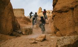
The CPGANG Takes a Freeride Road Trip to Spain
Nov 3, 2021 from pinkbike.com
The landscape around Teruel reminds us of Utah's iconic landscapes.

Video: Spain's Next Generation of Freeriders
Jan 28, 2021 from pinkbike.com
9-year-old Emric 9 and 12-year old Raoul go big beyond their years La Fenasosa.
Video: Mario Morata Shreds the New Lines at La Fenasosa Bike Park
Jul 8, 2020 from pinkbike.com
Taking a spin through Alicante's Nico Vink designed trails.
Popular La Fenasosa Mountain Biking Trails
| status | title | difficulty | rating |
|---|---|---|---|
| Remonte hasta La Cruz | |||
| La Cruz | |||
| Wood Park | |||
| Remonte de la 8 | |||
| Media 8 | |||
| Four Cross | |||
| DH8 | |||
| Clancy's line a 8 | |||
| Clancy's inferior |
Videos of La Fenasosa Mountain Bike
trail: La Cruz
4:03 |
156 |
Jan 20, 2018
Recent Trail Reports
| status | trail | date | condition | info | user |
|---|---|---|---|---|---|
| Media 8 | Sep 11, 2020 @ 7:27am Sep 11, 2020 | Dry | xaibeeh | ||
| Remonte de la 8 | Sep 11, 2020 @ 7:27am Sep 11, 2020 | Dry | xaibeeh | ||
| La Cruz | Sep 11, 2020 @ 7:27am Sep 11, 2020 | Dry | xaibeeh | ||
| Wood Park | Sep 11, 2020 @ 7:27am Sep 11, 2020 | Dry | xaibeeh | ||
| Remonte hasta La Cruz | Sep 11, 2020 @ 7:27am Sep 11, 2020 | Dry | xaibeeh | ||
| Four Cross | Sep 11, 2020 @ 7:27am Sep 11, 2020 | Dry | xaibeeh | ||
| DH8 | Nov 27, 2017 @ 8:33am Nov 27, 2017 | Dry | elyari TRAILFORKS |
Activity Feed
| username | action | type | title | date | |
|---|---|---|---|---|---|
 | erox22 | ridden | trail | Remonte hasta La Cruz | Mar 11, 2022 @ 3:33am Mar 11, 2022 |
| erox22 | wishlist | trail | Remonte hasta La Cruz | Mar 11, 2022 @ 3:32am Mar 11, 2022 |
| pedrojoseclimbing | checkin | trail | Clancy's line a 8 | Jan 9, 2022 @ 6:20am Jan 9, 2022 |
| pedrojoseclimbing | ridden | trail | Clancy's line a 8 | Jan 9, 2022 @ 6:20am Jan 9, 2022 |
| MathieuI3SCd9 | ridden | trail | La Cruz | Dec 20, 2021 @ 11:07am Dec 20, 2021 |
Nearby Areas
| name | distance | ||||
|---|---|---|---|---|---|
| Sierra Mariola | 1 | 16 | 5.4 km | ||
| Castalla | 6.3 km | ||||
| Sierra de Peña Rubia | 2 | 2 | 8.5 km | ||
| Sierra de la Villa | 3 | 1 | 9.2 km | ||
| El Morrón | 2 | 10.1 km |
Pinkbike Articles
Apr 7, 2022
 Video: Oscar Härnström’s Rides the New Intense 279 Tracer at La Fenasosa Bike Park
Riding Nico Vink's creations on a new bike.
Mar 28, 2022
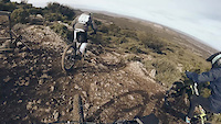
 Video: Smooth Style on a Winter Escape to La Fenasosa, Spain
Living slow and riding fast in La Fenaososa.
Feb 17, 2022
 Video: Freeriding in the South of Spain with Vinny T
Good times with friends on the DH bike.
Activity Type Stats
| activitytype | trails | distance | descent | descent distance | total vertical | rating | global rank | state rank | photos | reports | routes | ridelogs |
|---|---|---|---|---|---|---|---|---|---|---|---|---|
| Mountain Bike | 9 | 7 miles | 2,779 ft | 4 miles | 1,148 ft | #8,587 | #317 | 4 | 7 | 764 | ||
| E-Bike | 9 | 7 miles | 2,779 ft | 4 miles | 1,148 ft | #3,174 | #251 | 7 | 32 | |||
| Hike | 9 | 7 miles | 2,779 ft | 4 miles | 1,148 ft | 7 | ||||||
| Trail Running | 9 | 7 miles | 2,779 ft | 4 miles | 1,148 ft | 7 | 1 |
- By elyari
 TRAILFORKS & contributors
 - Admins: JavierRives
- #21174 - 3,873 views
- la fenasosa activity log | embed map of La Fenasosa mountain bike trails |
-
- subscribe
- 3d map
Downloading of trail gps tracks in kml & gpx formats is disabled for La Fenasosa.