close
Trail Conditions
- Unknown
- Snow Groomed
- Snow Packed
- Snow Covered
- Snow Cover Inadequate
- Freeze/thaw Cycle
- Icy
- Prevalent Mud
- Wet
- Variable
- Ideal
- Dry
- Very Dry
Trail Flow (Ridden Direction)
Trailforks scans users ridelogs to determine the most popular direction each trail is ridden. A good flowing trail network will have most trails flowing in a single direction according to their intension.
The colour categories are based on what percentage of riders are riding a trail in its intended direction.
The colour categories are based on what percentage of riders are riding a trail in its intended direction.
- > 96%
- > 90%
- > 80%
- > 70%
- > 50%
- < 50%
- bi-directional trail
- no data
Trail Last Ridden
Trailforks scans ridelogs to determine the last time a trail was ridden.
- < 2 days
- < 1 week
- < 2 weeks
- < 1 month
- < 6 months
- > 6 months
Trail Ridden Direction
The intended direction a trail should be ridden.
- Downhill Only
- Downhill Primary
- Both Directions
- Uphill Primary
- Uphill Only
- One Direction
Contribute Details
Colors indicate trail is missing specified detail.
- Description
- Photos
- Description & Photos
- Videos
Trail Popularity ?
Trailforks scans ridelogs to determine which trails are ridden the most in the last 9 months.
Trails are compared with nearby trails in the same city region with a possible 25 colour shades.
Think of this as a heatmap, more rides = more kinetic energy = warmer colors.
- most popular
- popular
- less popular
- not popular
ATV/ORV/OHV Filter
Max Vehicle Width
inches
Radar Time
x
Activity Recordings
Trailforks users anonymized public ridelogs from the past 6 months.
- mountain biking recent
- mountain biking (>6 month)
- hiking (1 year)
- moto (1 year)
Activity Recordings
Trailforks users anonymized public skilogs from the past 12 months.
- Downhill Ski
- Backcountry Ski
- Nordic Ski
Jump Magnitude Heatmap
Heatmap of where riders jump on trails. Zoom in to see individual jumps, click circles to view jump details.
Trails Deemphasized
Trails are shown in grey.
Only show trails with NO bikes.
Save the current map location and zoom level as your default home location whenever this page is loaded.
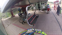
SaveBike Park. Open only on weekends.One of the best in Spain, technical natural trails and trails built with table jumps and double, big coners, very beautiful surrounding area, trails in open area, many trails in forest area, in summer the cable car is priced at 20 euros, has Hostel well Equipped with a private bathroom right next to the cable car, for dinner, you have to go to the small village 5 minutes by car, Riaza, because in the area of Bike park closes everything before 18h.
18 trails, All with very good maintenance throughout the season.
18 trails, All with very good maintenance throughout the season.
Primary Trail Type: All-Mountain & Downhill
Shuttleable: YES
Land Status: Ski Resort
 google parking directions
Links
This region uses the Uk/Euro style trail grading system.
Activities Click to view
- Mountain Bike
20 trails
- Hike
0 trails
- Trail Running
0 trails
Bike Park Details
- 1
- 12
- 2
- 2
Region Status
Open as of Jul 3, 2020- Day Ticket
- 20 EUR
- Uplift Type
- Chair Lift
Stats
- Avg Trail Rating
- Trails (view details)
- 20
- Trails Mountain Bike
- 20
- Total Distance
- 8 miles
- Total Descent
- 6,722 ft
- Total Vertical
- 1,115 ft
- Highest Trailhead
- 6,076 ft
- Reports
- 144
- Photos
- 117
- Ridden Counter
- 2,080
Popular La Pinilla Bikepark Mountain Biking Trails
La Pinilla Bikepark Mountain Bike Routes
| title | rating | distance |
|---|---|---|
| Hayedo de la Pedrosa (II) | 2 miles | |
| Red Bull HolyBike 2021: day 1 race | 7 miles | |
| Red Bull HolyBike 2021: day 2 race | 7 miles | |
| 27 mile La Pinilla Bikepark Ride | popular ridelog | 27 miles |
| 19 mile La Pinilla Bikepark Ride | popular ridelog | 19 miles |
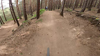
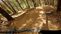
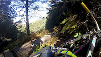
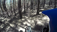
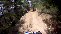
Photos of La Pinilla Bikepark Mountain Bike
trail: Hadas
113 |
May 14, 2018 @ 8:16am
May 14, 2018
trail: Holy Bike
68 |
Jun 15, 2017 @ 4:34am
Jun 15, 2017
trail: Holy Bike
58 |
Jun 15, 2017 @ 4:28am
Jun 15, 2017
trail: SX
443 |
Oct 14, 2016 @ 4:27am
Oct 14, 2016
trail: SX
144 |
Oct 11, 2016 @ 5:21am
Oct 11, 2016
trail: SX
333 |
Oct 11, 2016 @ 5:20am
Oct 11, 2016
trail: Exit
329 |
Aug 21, 2012 @ 1:01pm
Aug 21, 2012
trail: Exit
1,501 |
Jun 24, 2010 @ 1:48am
Jun 24, 2010Videos of La Pinilla Bikepark Mountain Bike
trail: Bike Patrol
52 |
Jun 17, 2022
trail: Bike Patrol
74 |
Aug 1, 2021
trail: Retorno
0:08 |
208 |
Jan 5, 2020

trail: Holy Bike
4:26 |
54 |
Oct 30, 2018
trail: Holy Bike
2:15 |
44 |
Nov 12, 2017
trail: Iniciación
0:54 |
30 |
Oct 30, 2017
trail: Bike Patrol
3:14 |
69 |
Jun 25, 2017
trail: Holy Bike
4:10 |
197 |
Dec 27, 2016
Recent Trail Reports
| status | trail | date | condition | info | user |
|---|---|---|---|---|---|
| SX | Jun 11, 2021 @ 5:57pm Jun 11, 2021 | Ideal | Pablice | ||
| Retorno | Jun 11, 2021 @ 5:57pm Jun 11, 2021 | Ideal | Pablice | ||
| Vertical | Jun 11, 2021 @ 5:57pm Jun 11, 2021 | Ideal | Pablice | ||
| Iniciación | Jun 11, 2021 @ 5:57pm Jun 11, 2021 | Ideal | Pablice | ||
| Flow Line | Jun 11, 2021 @ 5:57pm Jun 11, 2021 | Ideal | Pablice | ||
| Holy Bike | Sep 26, 2020 @ 1:22am Sep 26, 2020 | Ideal | Ramonudo | ||
| Campeonato de España | Sep 26, 2020 @ 1:22am Sep 26, 2020 | Ideal | Ramonudo | ||
| Secret | Sep 26, 2020 @ 1:22am Sep 26, 2020 | Ideal | Ramonudo | ||
| The River | Sep 26, 2020 @ 1:22am Sep 26, 2020 | Ideal | Ramonudo | ||
| Bike Patrol | Sep 26, 2020 @ 1:22am Sep 26, 2020 | Ideal | Ramonudo |
Activity Feed
| username | action | type | title | date | |
|---|---|---|---|---|---|
 | allmountrailmtb | add | video | ♀️ El Mirador | La Pinilla Bike Park (Segovia) | Enduro MTB l ORBEA OCCAM | Jun 17, 2022 @ 11:22pm Jun 17, 2022 |
 | MiguelSousa | add | video | Big crash at La Pinilla Bike Park | Jun 17, 2022 @ 3:58am Jun 17, 2022 |
 | agrey71 | ridden | trail | Ardillas and 11 more | May 9, 2022 @ 1:02pm May 9, 2022 |
| Bikingo | ridden | trail | Holy Bike and 3 more | Apr 23, 2022 @ 9:58am Apr 23, 2022 |
 | Josetom4s | vote | trail | Holy Bike and 2 more | Feb 7, 2022 @ 5:43am Feb 7, 2022 |
Recent Comments
| username | type | title | comment | date | |
|---|---|---|---|---|---|
 | trail | buenos peraltes tiene desde luego :P | May 20, 2019 @ 12:47am May 20, 2019 | ||
| trail | Una maravilla el estado en el que está, y de... | May 20, 2019 @ 12:47am May 20, 2019 |
Nearby Areas
| name | distance | ||||
|---|---|---|---|---|---|
| Sierra Norte de Guadalajara | 21 | 51 | 13.4 km | ||
| El Atazar | 2 | 17.8 km | |||
| Patones | 6 | 15 | 21.9 km | ||
| Sierra de La Cabrera | 4 | 27 | 25.4 km | ||
| Puerto de la Morcuera | 1 | 32.1 km |
- By coletassoft
 & contributors
 - Admins: apply
- #5745 - 5,960 views
- la pinilla bikepark activity log | embed map of La Pinilla Bikepark mountain bike trails | la pinilla bikepark mountain biking points of interest
-
- subscribe
- 3d map
Downloading of trail gps tracks in kml & gpx formats is enabled for La Pinilla Bikepark.
You must login to download files.