close
Trail Conditions
- Unknown
- Snow Groomed
- Snow Packed
- Snow Covered
- Snow Cover Inadequate
- Freeze/thaw Cycle
- Icy
- Prevalent Mud
- Wet
- Variable
- Ideal
- Dry
- Very Dry
Trail Flow (Ridden Direction)
Trailforks scans users ridelogs to determine the most popular direction each trail is ridden. A good flowing trail network will have most trails flowing in a single direction according to their intension.
The colour categories are based on what percentage of riders are riding a trail in its intended direction.
The colour categories are based on what percentage of riders are riding a trail in its intended direction.
- > 96%
- > 90%
- > 80%
- > 70%
- > 50%
- < 50%
- bi-directional trail
- no data
Trail Last Ridden
Trailforks scans ridelogs to determine the last time a trail was ridden.
- < 2 days
- < 1 week
- < 2 weeks
- < 1 month
- < 6 months
- > 6 months
Trail Ridden Direction
The intended direction a trail should be ridden.
- Downhill Only
- Downhill Primary
- Both Directions
- Uphill Primary
- Uphill Only
- One Direction
Contribute Details
Colors indicate trail is missing specified detail.
- Description
- Photos
- Description & Photos
- Videos
Trail Popularity ?
Trailforks scans ridelogs to determine which trails are ridden the most in the last 9 months.
Trails are compared with nearby trails in the same city region with a possible 25 colour shades.
Think of this as a heatmap, more rides = more kinetic energy = warmer colors.
- most popular
- popular
- less popular
- not popular
ATV/ORV/OHV Filter
Max Vehicle Width
inches
Radar Time
x
Activity Recordings
Trailforks users anonymized public ridelogs from the past 6 months.
- mountain biking recent
- mountain biking (>6 month)
- hiking (1 year)
- moto (1 year)
Activity Recordings
Trailforks users anonymized public skilogs from the past 12 months.
- Downhill Ski
- Backcountry Ski
- Nordic Ski
Jump Magnitude Heatmap
Heatmap of where riders jump on trails. Zoom in to see individual jumps, click circles to view jump details.
Trails Deemphasized
Trails are shown in grey.
Only show trails with NO bikes.
Save the current map location and zoom level as your default home location whenever this page is loaded.
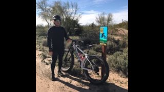
Save100-Acre Wood Bike Park is a partnership between the Sonoran Desert Mountain Bicyclists (501c3), the City of Tucson, and Davis-Monthan Air Force Base. The bike park will be funded through donations, sponsorships, grants, in-kind donations, and a whole bunch of volunteer labor.
Primary Trail Type: Cross-Country
Land Status: City Managed
Land Manager: City of Tucson
 google parking directions
Links
Region Supporters & Maintainers
![IMBA Silver Ride Center]()
IMBA Silver Ride CenterSponsor
Activities Click to view
- Mountain Bike
20 trails
- E-Bike
13 trails
- Hike
7 trails
- Trail Running
7 trails
Region Details
- 4
- 3
- 8
- 3
- 2
Region Status
Open as of Jun 12, 2022Stats
- Avg Trail Rating
- Trails (view details)
- 20
- Trails Mountain Bike
- 20
- Trails E-Bike
- 13
- Trails Hike
- 7
- Trails Trail Running
- 7
- Total Distance
- 20 miles
- Total Descent
- 395 ft
- Total Vertical
- 366 ft
- Highest Trailhead
- 2,747 ft
- Reports
- 108
- Photos
- 15
- Ridden Counter
- 2,658
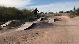
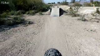
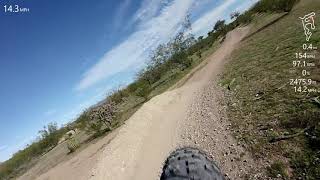
Popular 100-Acre Wood Bike Park Mountain Biking Trails
Photos of 100-Acre Wood Bike Park Mountain Bike
trail: Advanced XC Trail
42 |
Jan 17, 2022 @ 3:17pm
Jan 17, 2022
trail: Intermediate Jump Line
231 |
May 29, 2020 @ 9:38pm
May 29, 2020
trail: Intermediate Jump Line
203 |
Sep 24, 2019 @ 1:47pm
Sep 24, 2019
trail: Intermediate Jump Line
205 |
Sep 24, 2019 @ 1:46pm
Sep 24, 2019
trail: Intermediate Jump Line
461 |
Sep 24, 2019 @ 1:46pm
Sep 24, 2019
trail: Intermediate Jump Line
184 |
Sep 24, 2019 @ 1:44pm
Sep 24, 2019
trail: Intermediate Jump Line
202 |
Aug 1, 2019 @ 1:40pm
Aug 1, 2019
trail: Easy Jump Line
234 |
Aug 1, 2019 @ 1:39pm
Aug 1, 2019Videos of 100-Acre Wood Bike Park Mountain Bike

trail: Intermediate Jump Line
0:11 |
147 |
Sep 24, 2019

trail: #3 Easy Flow Trail
0:32 |
206 |
Sep 24, 2019
trail: Intermediate Jump Line
0:13 |
199 |
Oct 4, 2020 , My City
trail: Easy Jump Line
0:12 |
189 |
Oct 4, 2020 , My City
trail: Intermediate Jump Line
0:28 |
278 |
Oct 4, 2020 , My City

trail: Easy Jump Line
0:28 |
150 |
Oct 4, 2020 , My City
trail: Easy XC Trail
2:33 |
372 |
Oct 4, 2020 , My City
Current Trail Warnings
| status | trail | date | condition | user | info |
|---|---|---|---|---|---|
| Advanced XC Trail | Jun 12, 2022 @ 6:19pm Jun 12, 2022 | Variable | tamalesnatcher3000 | The Advanced XC trail has been overrun by... |
Recent Trail Reports
| status | trail | date | condition | info | user |
|---|---|---|---|---|---|
| The Loop: Pantano Wash | Feb 3, 2022 @ 11:31am Feb 3, 2022 | Ideal | reusserfarm | ||
| Pantano Wash Crossing | Feb 3, 2022 @ 11:31am Feb 3, 2022 | Unknown | reusserfarm | ||
| Intermediate XC Trail | Jan 23, 2022 @ 1:17pm Jan 23, 2022 | Ideal | paddyredbeard | ||
| Easy XC Trail | Jan 23, 2022 @ 1:17pm Jan 23, 2022 | Ideal | paddyredbeard | ||
| The Loop | Nov 6, 2021 @ 7:24am Nov 6, 2021 | Dry | crpocock | ||
| Zone 1 Access Road | Jan 31, 2021 @ 10:23am Jan 31, 2021 | Dry | Maligatork9 | ||
| #3 Easy Flow Trail | Jan 14, 2021 @ 2:33pm Jan 14, 2021 | Dry | judge-shredd | ||
| #2 Intermediate Flow Trail | Jan 14, 2021 @ 2:33pm Jan 14, 2021 | Dry | judge-shredd | ||
| #1 Advanced Flow Trail | Jan 14, 2021 @ 2:33pm Jan 14, 2021 | Dry | judge-shredd | ||
| Easy Jump Line | Jan 14, 2021 @ 2:33pm Jan 14, 2021 | Dry | judge-shredd |
Activity Feed
| username | action | type | title | date | |
|---|---|---|---|---|---|
 | tamalesnatcher3000 | add | report | Advanced XC Trail | Jun 12, 2022 @ 6:21pm Jun 12, 2022 |
| tamalesnatcher3000 | wishlist | trail | Advanced XC Trail | Apr 9, 2022 @ 6:09pm Apr 9, 2022 |
 | BillxvRWuT | wishlist | trail | #1 Advanced Flow Trail | Mar 7, 2022 @ 5:50pm Mar 7, 2022 |
| reusserfarm | add | report | The Loop: Pantano Wash and 1 more | Feb 3, 2022 @ 3:06pm Feb 3, 2022 |
| rcstoddard | ridden | trail | Advanced XC Trail and 9 more | Jan 24, 2022 @ 10:46am Jan 24, 2022 |
Recent Comments
| username | type | title | comment | date | |
|---|---|---|---|---|---|
 | trail | This whole area is surrounded by a giant... | Jan 8, 2022 @ 6:47pm Jan 8, 2022 | ||
 | trail | Kinda fun little trail with some berms and... | Dec 15, 2020 @ 1:50pm Dec 15, 2020 |
Nearby Areas
| name | distance | ||||
|---|---|---|---|---|---|
| PCC West | 21 | 7.3 km | |||
| Fantasy Island | 10 | 11 | 7.4 km | ||
| Enchanted Hills | 9 | 2 | 1 | 1 | 7.7 km |
| Greasewood Park | 16 | 7.7 km | |||
| Painted Hills | 1 | 2 | 4 | 8.7 km |
Bike & Skill Parks
| name | type | city | rating |
|---|---|---|---|
| 100-Acre Wood Bike Park | skill park |
Activity Type Stats
| activitytype | trails | distance | descent | descent distance | total vertical | rating | global rank | state rank | photos | reports | routes | ridelogs |
|---|---|---|---|---|---|---|---|---|---|---|---|---|
| Mountain Bike | 20 | 20 miles | 394 ft | 7 miles | 367 ft | #2,620 | #1,312 | 14 | 108 | 2,636 | ||
| E-Bike | 13 | 6 miles | 128 ft | 2 miles | 79 ft | #885 | #258 | 1 | 107 | 44 | ||
| Hike | 7 | 14 miles | 266 ft | 5 miles | 367 ft | #8,030 | #3,640 | 105 | 10 | |||
| Trail Running | 7 | 14 miles | 266 ft | 5 miles | 367 ft | #8,010 | #3,624 | 105 | 51 |
- By jeffgicklhorn
 SDMB & contributors
 - Admins: SDMB
- #28062 - 7,013 views
- 100-acre wood bike park activity log | embed map of 100-Acre Wood Bike Park mountain bike trails | 100-acre wood bike park mountain biking points of interest
Downloading of trail gps tracks in kml & gpx formats is enabled for 100-Acre Wood Bike Park.
You must login to download files.