close
Trail Conditions
- Unknown
- Snow Groomed
- Snow Packed
- Snow Covered
- Snow Cover Inadequate
- Freeze/thaw Cycle
- Icy
- Prevalent Mud
- Wet
- Variable
- Ideal
- Dry
- Very Dry
Trail Flow (Ridden Direction)
Trailforks scans users ridelogs to determine the most popular direction each trail is ridden. A good flowing trail network will have most trails flowing in a single direction according to their intension.
The colour categories are based on what percentage of riders are riding a trail in its intended direction.
The colour categories are based on what percentage of riders are riding a trail in its intended direction.
- > 96%
- > 90%
- > 80%
- > 70%
- > 50%
- < 50%
- bi-directional trail
- no data
Trail Last Ridden
Trailforks scans ridelogs to determine the last time a trail was ridden.
- < 2 days
- < 1 week
- < 2 weeks
- < 1 month
- < 6 months
- > 6 months
Trail Ridden Direction
The intended direction a trail should be ridden.
- Downhill Only
- Downhill Primary
- Both Directions
- Uphill Primary
- Uphill Only
- One Direction
Contribute Details
Colors indicate trail is missing specified detail.
- Description
- Photos
- Description & Photos
- Videos
Trail Popularity ?
Trailforks scans ridelogs to determine which trails are ridden the most in the last 9 months.
Trails are compared with nearby trails in the same city region with a possible 25 colour shades.
Think of this as a heatmap, more rides = more kinetic energy = warmer colors.
- most popular
- popular
- less popular
- not popular
ATV/ORV/OHV Filter
Max Vehicle Width
inches
Radar Time
x
Activity Recordings
Trailforks users anonymized public ridelogs from the past 6 months.
- mountain biking recent
- mountain biking (>6 month)
- hiking (1 year)
- moto (1 year)
Activity Recordings
Trailforks users anonymized public skilogs from the past 12 months.
- Downhill Ski
- Backcountry Ski
- Nordic Ski
Jump Magnitude Heatmap
Heatmap of where riders jump on trails. Zoom in to see individual jumps, click circles to view jump details.
Trails Deemphasized
Trails are shown in grey.
Only show trails with NO bikes.
Save the current map location and zoom level as your default home location whenever this page is loaded.
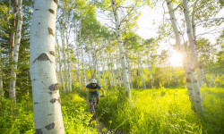
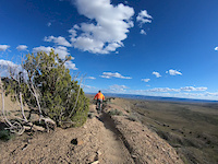
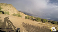
SaveTons of flow and amazing views of the Book Cliffs out at 18 road. Icon trails like Kessel Run and PBR make the dusty drive up the road worth the trip.
AKA: Book Cliffs
 google parking directions
 Activities Click to view
- Mountain Bike
39 trails
- E-Bike
28 trails
- Hike
35 trails
- Trail Running
35 trails
Region Details
- 9
- 5
- 19
- 5
- 1
Region Status
Open as of Nov 28, 2021Stats
- Avg Trail Rating
- Trails (view details)
- 39
- Trails Mountain Bike
- 39
- Trails E-Bike
- 28
- Trails Hike
- 35
- Trails Trail Running
- 35
- Trails Horse
- 1
- Trails Dirtbike/Moto
- 5
- Total Distance
- 101 miles
- Total Descent
- 10,092 ft
- Total Vertical
- 2,594 ft
- Highest Trailhead
- 7,353 ft
- Reports
- 437
- Photos
- 301
- Ridden Counter
- 21,312
 Articles
Colorado's 5 Most Popular Trail Networks According to Trailforks Data
Oct 20, 2021 from pinkbike.com
Colorado is the eighth most expansive of the 50 states by area and is home to 53 different mountain peaks in excess of 14,000 feet above sea level.
Popular 18 Road Mountain Biking Trails
18 Road Mountain Bike Routes
| title | rating | distance |
|---|---|---|
| Roam Fest Fruita 18 Rd Joe's Ridge | 5 miles | |
| Fruita Ultimate Flow at 18 Road | 18 miles | |
| Roam Fest Fruita 18 Rd PBR | 4 miles | |
| Roam Fest Fruita 18 Rd Zippity | 7 miles | |
| Zippity Do Da with Joes and MJoes | 14 miles | |
| Zippity Do Da with Joes and MJoes | 14 miles | |
| Roam Fest Fruita 18 Rd Kessel Run | 4 miles | |
| Kessel Run Laps | 4 miles | |
| The Zippity Loop | 8 miles | |
| PBR Laps | 4 miles |
Photos of 18 Road Mountain Bike
trail: Zippity Do Dah
15 |
Apr 18, 2022 @ 6:34pm
Apr 18, 2022
trail: Frontside
12 |
Apr 18, 2022 @ 6:25pm
Apr 18, 2022
trail: Joes Ridge
52 |
Oct 20, 2021 @ 8:01am
Oct 20, 2021
trail: Joes Ridge
190 |
May 29, 2020 @ 6:17pm
May 29, 2020
trail: Joes Ridge
269 |
Jun 6, 2019 @ 4:39pm
Jun 6, 2019
trail: Zippity Do Dah
642 |
Dec 15, 2015 @ 7:42pm
Dec 15, 2015
trail: Mojoe
661 |
May 13, 2015 @ 7:12pm
May 13, 2015
trail: Mojoe
312 |
Dec 6, 2014 @ 11:35am
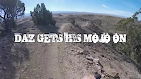
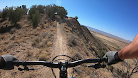
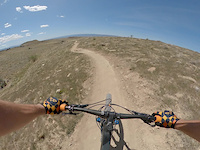
Dec 6, 2014Videos of 18 Road Mountain Bike

trail: Zippity Do Dah
77 |
Sep 17, 2021

trail: 18 Road
38 |
May 24, 2021
trail: Joes Ridge
44 |
Apr 24, 2021
trail: Zippity Do Dah
121 |
Nov 7, 2020
trail: PBR
0:18 |
|
May 15, 2020
trail: Zippity Do Dah
0:21 |
78 |
May 13, 2020
trail: PBR
0:51 |
144 |
Jan 29, 2017
trail: Zippity Do Dah
1:35 |
122 |
Jan 29, 2017
Recent Trail Reports
| status | trail | date | condition | info | user |
|---|---|---|---|---|---|
| Western Zippity | Jul 2, 2022 @ 9:36am Jul 2, 2022 | Dry | ertoo | ||
| Zippity Do Dah | Jul 2, 2022 @ 9:36am Jul 2, 2022 | Dry | ertoo | ||
| Zippity | Jul 2, 2022 @ 9:36am Jul 2, 2022 | Dry | ertoo | ||
| PBR | Jul 2, 2022 @ 9:36am Jul 2, 2022 | Dry | ertoo | ||
| Joes Ridge | Jun 24, 2022 @ 7:58am Jun 24, 2022 | Ideal | WillMatt | ||
| Mojoe | Jun 24, 2022 @ 7:58am Jun 24, 2022 | Ideal | WillMatt | ||
| Down Uppity | Jun 14, 2022 @ 9:01am Jun 14, 2022 | Dry | dwhanson | ||
| Prime Cut | Jun 4, 2022 @ 8:20am Jun 4, 2022 | Dry | dwhanson | ||
| Frontside | May 17, 2022 @ 6:12am May 17, 2022 | Ideal | Lmpicard | ||
| Frontside NW | May 12, 2022 @ 11:45am May 12, 2022 | Dry | sevenoff |
Activity Feed
| username | action | type | title | date | |
|---|---|---|---|---|---|
 | msmcfate | add | trail | Zip Up | Jul 3, 2022 @ 7:26am 3 days |
 | ertoo | add | trail | Zip Up | Jul 3, 2022 @ 7:25am 3 days |
| ertoo | add | report | Western Zippity and 3 more | Jul 2, 2022 @ 3:02pm Jul 2, 2022 |
| Oxente | wishlist | trail | Joes Ridge | Jul 1, 2022 @ 10:03am Jul 1, 2022 |
 | WillMatt | add | report | PBR and 2 more | Jun 26, 2022 @ 1:56pm Jun 26, 2022 |
Recent Comments
| username | type | title | comment | date | |
|---|---|---|---|---|---|
| trail | Super fun trail! | May 21, 2022 @ 7:14pm May 21, 2022 | ||
| trail | Tough climb | May 21, 2022 @ 7:12pm May 21, 2022 | ||
| trail | features are all manageable or have clear... | Dec 12, 2021 @ 12:09pm Dec 12, 2021 | ||
| trail | awesome! views and exposure make this trail a... | Dec 12, 2021 @ 12:06pm Dec 12, 2021 | ||
| trail | first half is super fun, enough steepness to... | Dec 12, 2021 @ 11:15am Dec 12, 2021 |
Nearby Areas
| name | distance | ||||
|---|---|---|---|---|---|
| Highline Lake State Park | 3 | 5 | 9.3 km | ||
| Kokopelli Loops | 6 | 14 | 6 | 2 | 13.4 km |
| McInnis Canyon National Conservation Area | 14.8 km | ||||
| Redlands | 19 | 13 | 1 | 17.9 km | |
| Lunch Loops | 8 | 28 | 18 | 3 | 20.3 km |
Local Badges
-

Completionist0 awarded
Pinkbike Articles
Oct 20, 2021
 Colorado's 5 Most Popular Trail Networks According to Trailforks Data
Colorado is the eighth most expansive of the 50 states by area and is home to 53 different mountain peaks in excess of 14,000 feet above sea level.
Mar 17, 2020
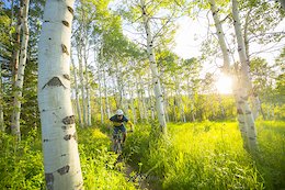
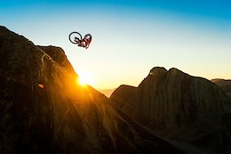
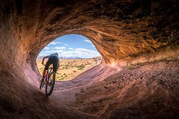 Photo Story: Stunning Images in 'Unsettling - Going Full Nomad'
A year of being houseless and chasing happiness.
Sep 4, 2018
 5 Years of Photography with Niner Bikes' In-House Photographer
Ian Hylands took on a role as full-time in-house photographer for Niner Bikes in 2013. These are his best images from the past five years on the job.
Activity Type Stats
| activitytype | trails | distance | descent | descent distance | total vertical | rating | global rank | state rank | photos | reports | routes | ridelogs |
|---|---|---|---|---|---|---|---|---|---|---|---|---|
| Mountain Bike | 39 | 101 miles | 10,092 ft | 35 miles | 2,595 ft | #207 | #89 | 289 | 434 | 16 | 11,324 | |
| E-Bike | 28 | 82 miles | 6,463 ft | 26 miles | 2,595 ft | #87 | #25 | 12 | 373 | 2 | 87 | |
| Hike | 35 | 97 miles | 9,203 ft | 32 miles | 2,595 ft | #209 | #115 | 411 | 20 | |||
| Trail Running | 35 | 97 miles | 9,203 ft | 32 miles | 2,595 ft | #208 | #112 | 411 | 26 | |||
| Horse | 1 | 7 miles | 1,542 ft | 4 miles | 797 ft | 123 | 2 | |||||
| Dirtbike/Moto | 5 | 23 miles | 3,015 ft | 9 miles | 2,090 ft | 124 | 1 | 7 |
- By brenthillier
 NSMBA TRAILFORKS & contributors
 - Admins: COPMOBA, GVTA, grandvalleydave
- #3485 - 26,239 views
- 18 road activity log | embed map of 18 Road mountain bike trails | 18 road mountain biking points of interest
Downloading of trail gps tracks in kml & gpx formats is enabled for 18 Road.
You must login to download files.