close
Trail Conditions
- Unknown
- Snow Groomed
- Snow Packed
- Snow Covered
- Snow Cover Inadequate
- Freeze/thaw Cycle
- Icy
- Prevalent Mud
- Wet
- Variable
- Ideal
- Dry
- Very Dry
Trail Flow (Ridden Direction)
Trailforks scans users ridelogs to determine the most popular direction each trail is ridden. A good flowing trail network will have most trails flowing in a single direction according to their intension.
The colour categories are based on what percentage of riders are riding a trail in its intended direction.
The colour categories are based on what percentage of riders are riding a trail in its intended direction.
- > 96%
- > 90%
- > 80%
- > 70%
- > 50%
- < 50%
- bi-directional trail
- no data
Trail Last Ridden
Trailforks scans ridelogs to determine the last time a trail was ridden.
- < 2 days
- < 1 week
- < 2 weeks
- < 1 month
- < 6 months
- > 6 months
Trail Ridden Direction
The intended direction a trail should be ridden.
- Downhill Only
- Downhill Primary
- Both Directions
- Uphill Primary
- Uphill Only
- One Direction
Contribute Details
Colors indicate trail is missing specified detail.
- Description
- Photos
- Description & Photos
- Videos
Trail Popularity ?
Trailforks scans ridelogs to determine which trails are ridden the most in the last 9 months.
Trails are compared with nearby trails in the same city region with a possible 25 colour shades.
Think of this as a heatmap, more rides = more kinetic energy = warmer colors.
- most popular
- popular
- less popular
- not popular
ATV/ORV/OHV Filter
Max Vehicle Width
inches
Radar Time
x
Activity Recordings
Trailforks users anonymized public ridelogs from the past 6 months.
- mountain biking recent
- mountain biking (>6 month)
- hiking (1 year)
- moto (1 year)
Activity Recordings
Trailforks users anonymized public skilogs from the past 12 months.
- Downhill Ski
- Backcountry Ski
- Nordic Ski
Jump Magnitude Heatmap
Heatmap of where riders jump on trails. Zoom in to see individual jumps, click circles to view jump details.
Trails Deemphasized
Trails are shown in grey.
Only show trails with NO bikes.
Save the current map location and zoom level as your default home location whenever this page is loaded.
SaveNew York State subdivided into official 11 Tourism Regions as per official state website https://esd.ny.gov/regions
Region Details
- 789
- 179
- 1,145
- 1,722
- 530
- 53
- 3
Local Trail Association
Stats
- Avg Trail Rating
- Trails (view details)
- 9,043
- Trails Mountain Bike
- 4,431
- Trails E-Bike
- 426
- Trails Hike
- 5,939
- Trails Trail Running
- 5,499
- Trails Horse
- 476
- Trails Dirtbike/Moto
- 7
- Trails Observed Trials
- 9
- Trails ATV/ORV/OHV
- 3
- Trails Snowmobile
- 2,442
- Trails Snowshoe
- 1,011
- Trails Downhill Ski
- 305
- Trails Backcountry Ski
- 162
- Trails Nordic Ski
- 971
- Total Distance
- 16,796 miles
- Total Descent
- 1,698,576 ft
- Total Vertical
- 5,333 ft
- Highest Trailhead
- 5,333 ft
- Reports
- 34,813
- Photos
- 7,615
- Ridden Counter
- 403,863
 Articles
See the Country's Finest Fall Colors on this Catskills Overnight
Sep 20, 2021 from backpacker.com
This 12.1-mile overnight bags a Catskills Peak on the way to your lean-to camp spot.
The Ultimate Road-Trip Guide to New York’s Finger Lakes
Aug 30, 2021 from outsideonline.com
From towering waterfalls to long-distance trails, this 90-mile stretch of Route 20 packs the region’s best adventures into one trip
Whiteface Mountain Bike Park Will Not Open for the 2020 Season
May 11, 2020 from pinkbike.com
Following a decision by the Olympic Regional Development Authority the Whiteface Mountain Bike Park won't open this year.
Video & Race Report: A Steep, Raw and Rowdy Finale to the ESC Downhill Series - Plattekill, NY
Oct 23, 2019 from pinkbike.com
Maxxis ESC Intense Downhill Series Finals took place on a track that was quintessentially Platty
Popular Trail Networks
view all areas »Sub Regions
- Capital Region (735)
- Albany County (107)
- Columbia County (75)
- Greene County (165)
- Rensselaer County (88)
- Saratoga County (136)
- Schenectady County (49)
- Warren County (115)
- Central New York Region (260)
- Cortland County (28)
- Madison County (36)
- Onondaga County (155)
- Oswego County (41)
- Finger Lakes Region (251)
- Genesee County (4)
- Livingston County (46)
- Monroe County (59)
- Ontario County (119)
- Seneca County (6)
- Wayne County (1)
- Wyoming County (5)
- Yates County (2)
- Long Island Region (585)
- Nassau County (80)
- Queens County (24)
- Suffolk County (485)
- Mid Hudson Valley Region (888)
- Dutchess County (97)
- Orange County (213)
- Putnam County (120)
- Rockland County (74)
- Sullivan County (34)
- Ulster County (182)
- Westchester County (162)
- Mohawk Valley Region (454)
- Fulton County (39)
- Herkimer County (132)
- Oneida County (67)
- Otsego County (187)
- New York City Region (94)
- Kings County (36)
- New York County (10)
- Richmond County (20)
- North Country Region (497)
- Clinton County (69)
- Essex County (238)
- Franklin County (7)
- Hamilton County (30)
- Jefferson County (14)
- Lewis County (4)
- Saint Lawrence County (135)
- Southern Tier Region (442)
- Broome County (78)
- Chenango County (49)
- Delaware County (52)
- Schuyler County (30)
- Steuben County (69)
- Tioga County (50)
- Tompkins County (114)
- Western New York Region (277)
- Cattaraugus County (147)
- Chautauqua County (56)
- Erie County (67)
- Niagara County (7)
Popular New York State Mountain Biking Trails
| status | title | difficulty | rating |
|---|---|---|---|
| Outerloops North Elm Ridge Wild Forest | |||
| UpDraft - Crank Cycles - WMBA Trail Hunt Graham Hills Park | |||
| Floworks 17 Sterling Forest State Park | |||
| Ridges Loop Glacier Ridge | |||
| Palisades 18 Sterling Forest State Park | |||
| I See Dead People Stillwell Woods Park | |||
| Ewok Forest Stillwell Woods Park | |||
| Coaster Gurney Lane | |||
| Twisted Sister Stillwell Woods Park | |||
| CR83 N 2 Sidewinder Glacier Ridge | |||
| Sidewinder Glacier Ridge | |||
| CR83 South Glacier Ridge | |||
| Blue Loop Glacier Ridge | |||
| Double Black Diamond Glacier Ridge | |||
| What Goes Up Must Come Down Glacier Ridge |
New York State Mountain Bike Routes
| title | rating | distance |
|---|---|---|
| Meadowlark Complete Meadowlark Park | 5 miles | |
| Glacier Ridge, Overton & Cathedral Pines - LI Triple Crown Glacier Ridge | 49 miles | |
| Eastport Complete Eastport Conservation Area | 8 miles | |
| Stillwell Woods Complete Stillwell Woods Park | 6 miles | |
| HHW South Side Moderate Hempstead Harbor Woods | 3 miles | |
| Hidden Pond Complete Hidden Pond Park | 6 miles | |
| Calverton Complete Otis Pike Preserve (Calverton) | 9 miles | |
| HHW North Side Hempstead Harbor Woods | 1 mile | |
| Edgewood Green Edgewood Oak Brush Plains Reserve | 5 miles | |
| HHW South Side Hard Hempstead Harbor Woods | 4 miles |
Photos of New York State Mountain Bike
trail: Thriller
158 |
Nov 3, 2020 @ 9:10am
Nov 3, 2020
trail: Upper SIS - WMBA
445 |
Apr 23, 2020 @ 1:12pm
Apr 23, 2020
trail: Eric's Over the Log
121 |
Jan 25, 2020 @ 11:33am
Jan 25, 2020
trail: Eric's Over the Log
99 |
Jan 25, 2020 @ 11:33am
Jan 25, 2020
trail: North Bethlehem Park Trail
139 |
Dec 23, 2019 @ 8:59pm
Dec 23, 2019
trail: Slalom Course
691 |
May 4, 2009 @ 7:01am
May 4, 2009Videos of New York State Mountain Bike
trail: Y1
7 |
Jun 2, 2022

trail: The Phoenix (Red Trail)
14 |
May 17, 2022
trail: Bethpage Bikeway
|
Jan 2, 2022
trail: Log Ride
61 |
Dec 6, 2021
trail: Lower North Red
77 |
Aug 11, 2021
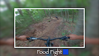
trail: Food Fight
49 |
Jul 22, 2021
trail: Batavia Skill
87 |
Jun 9, 2021

trail: Trail View To Stillwell
57 |
Jan 16, 2021
Activity Feed
| username | action | type | title | date | |
|---|---|---|---|---|---|
 | saford16 | wishlist | region | Rocky Point Conservation Area | Jul 5, 2022 @ 9:44pm 4 hours |
| davps2 | vote | trail | Elm Ridge Trail and 7 more | Jul 5, 2022 @ 6:40pm 7 hours |
| davps2 | add | report | Elm Ridge Trail and 15 more | Jul 5, 2022 @ 6:33pm 7 hours |
| davps2 | ridden | trail | Elm Ridge Trail and 15 more | Jul 5, 2022 @ 6:32pm 7 hours |
 | Jpmche | update | route | CTP Ridge Side - Intermediate Full Loop (Black Arrow) | Jul 5, 2022 @ 6:28pm 8 hours |
Recent Comments
| username | type | title | comment | date | |
|---|---|---|---|---|---|
| trail | This trail is currently open. | Jul 5, 2022 @ 5:29pm 9 hours | ||
| trail | Lots of bugs on the back side of the lake. Out... | Jul 2, 2022 @ 2:02pm Jul 2, 2022 | ||
| trail | Tried to treat this as an "enduro run" and... | Jun 30, 2022 @ 10:50am Jun 30, 2022 | ||
| report | Overgrown but rideable. | Jun 30, 2022 @ 9:45am Jun 30, 2022 | ||
| trail | Super fun “groomer” trail. Fast and flowy. | Jun 26, 2022 @ 4:37pm Jun 26, 2022 |
Local Badges
-

Trail Explorer 1001,982 awarded -

Top 10 Trails2,239 awarded -

10 Blue Trails402 awarded -
10 Blue Trails326 awarded -

Completionist2 awarded -
10 Blue Trails215 awarded
National Scenic Trails & Official Routes
-
Interloken Trail
- Mountain Bike
- Hike
- Horse
- Snowshoe
- Nordic Ski
-
Letchworth Trail/FLT
- Mountain Bike
- Hike

Bike & Skill Parks
| name | type | city | rating |
|---|---|---|---|
| Cascade Cross Country Ski Center | bike park | Lake Placid | |
| Greek Peak Mountain Resort | bike park | Cortland | |
| Holiday Valley | bike park | Ellicottville | |
| HoliMont Bike Park | bike park | Ellicottville | |
| Lapland Lake Cross Country Ski Center | bike park | Benson |
Activity Type Stats
| activitytype | trails | distance | descent | descent distance | total vertical | rating | global rank | state rank | photos | reports | routes | ridelogs |
|---|---|---|---|---|---|---|---|---|---|---|---|---|
| Mountain Bike | 4,431 | 3,903 miles | 470,722 ft | 1,568 mile | 3,976 ft | #14 | 7,447 | 34,567 | 260 | 402,731 | ||
| E-Bike | 426 | 419 miles | 31,883 ft | 167 miles | 2,510 ft | #24 | 5 | 21,849 | 18 | 3,094 | ||
| Hike | 5,939 | 6,694 miles | 796,417 ft | 2,488 miles | 5,335 ft | #10 | 146 | 34,144 | 65 | 18,379 | ||
| Trail Running | 5,499 | 6,380 miles | 769,551 ft | 2,360 miles | 5,335 ft | #10 | 1 | 34,182 | 30 | 5,517 | ||
| Horse | 476 | 1,299 mile | 106,850 ft | 386 miles | 5,322 ft | #24 | 1 | 7,372 | 34 | |||
| Dirtbike/Moto | 7 | 16 miles | 1,683 ft | 8 miles | 1,470 ft | #31 | 3 | 7,142 | 85 | |||
| Observed Trials | 9 | 7 miles | 374 ft | 2 miles | 413 ft | #20 | 1 | 15 | 93 | |||
| ATV/ORV/OHV | 3 | 5 miles | 420 ft | 2 miles | 1,316 ft | #38 | 7,137 | 98 | ||||
| Snowmobile | 2,442 | 10,046 miles | 784,843 ft | 3,715 miles | 3,507 ft | #10 | 353 | 64 | ||||
| Snowshoe | 1,011 | 1,621 mile | 141,237 ft | 444 miles | 4,610 ft | #18 | 6 | 6,594 | 3 | 1,102 | ||
| Downhill Ski | 305 | 109 miles | 73,409 ft | 88 miles | 3,068 ft | 1 | 94 | 3,659 | ||||
| Backcountry Ski | 162 | 180 miles | 23,858 ft | 74 miles | 4,068 ft | #7 | 289 | 1 | 1,079 | |||
| Nordic Ski | 971 | 1,348 mile | 123,327 ft | 433 miles | 4,357 ft | #13 | 4 | 735 | 5 | 3,252 |
- By canadaka
 Trailforks & contributors
 - Admins: Map Team, chuktA, msmcfate, WillieJacobsz, PlumbBobM, ReckitRolley, cmo-mtb, PlumbBobM
- #3147 - 59,410 views
- new york state activity log | embed map of New York State mountain bike trails | new york state mountain biking points of interest polygons
-
- subscribe
- 3d map
Downloading of trail gps tracks in kml & gpx formats is enabled for New York State.
You must login to download files.