close
Trail Conditions
- Unknown
- Snow Groomed
- Snow Packed
- Snow Covered
- Snow Cover Inadequate
- Freeze/thaw Cycle
- Icy
- Prevalent Mud
- Wet
- Variable
- Ideal
- Dry
- Very Dry
Trail Flow (Ridden Direction)
Trailforks scans users ridelogs to determine the most popular direction each trail is ridden. A good flowing trail network will have most trails flowing in a single direction according to their intension.
The colour categories are based on what percentage of riders are riding a trail in its intended direction.
The colour categories are based on what percentage of riders are riding a trail in its intended direction.
- > 96%
- > 90%
- > 80%
- > 70%
- > 50%
- < 50%
- bi-directional trail
- no data
Trail Last Ridden
Trailforks scans ridelogs to determine the last time a trail was ridden.
- < 2 days
- < 1 week
- < 2 weeks
- < 1 month
- < 6 months
- > 6 months
Trail Ridden Direction
The intended direction a trail should be ridden.
- Downhill Only
- Downhill Primary
- Both Directions
- Uphill Primary
- Uphill Only
- One Direction
Contribute Details
Colors indicate trail is missing specified detail.
- Description
- Photos
- Description & Photos
- Videos
Trail Popularity ?
Trailforks scans ridelogs to determine which trails are ridden the most in the last 9 months.
Trails are compared with nearby trails in the same city region with a possible 25 colour shades.
Think of this as a heatmap, more rides = more kinetic energy = warmer colors.
- most popular
- popular
- less popular
- not popular
ATV/ORV/OHV Filter
Max Vehicle Width
inches
Radar Time
x
Activity Recordings
Trailforks users anonymized public ridelogs from the past 6 months.
- mountain biking recent
- mountain biking (>6 month)
- hiking (1 year)
- moto (1 year)
Activity Recordings
Trailforks users anonymized public skilogs from the past 12 months.
- Downhill Ski
- Backcountry Ski
- Nordic Ski
Jump Magnitude Heatmap
Heatmap of where riders jump on trails. Zoom in to see individual jumps, click circles to view jump details.
Trails Deemphasized
Trails are shown in grey.
Only show trails with NO bikes.
Save the current map location and zoom level as your default home location whenever this page is loaded.
SaveThe 4R Ranch trail system is located north of Muenster, Texas on 4R Ranch. By virtue of the fact that the 1,132 acre ranch encompasses land that transitions from the shortgrass prairie to the Red River Valley, the ranch is blessed with magnificent vistas, multiple ridge lines, ravines and rocky terrain. These attributes make it an ideal site for mountain biking.
 google parking directions
 Disclaimer:
$10 fee per person per day
Links
Activities Click to view
- Mountain Bike
1 trails
- E-Bike
0 trails
- Hike
1 trails
- Trail Running
1 trails
Region Details
- 1
Region Status
Open as of May 9, 2022Stats
- Avg Trail Rating
- Trails (view details)
- 1
- Trails Mountain Bike
- 1
- Trails Hike
- 1
- Trails Trail Running
- 1
- Total Distance
- 9 miles
- Total Descent Distance
- 3 miles
- Total Descent
- 803 ft
- Total Vertical
- 241 ft
- Highest Trailhead
- 1,200 ft
- Reports
- 2
- Photos
- 11
- Ridden Counter
- 38
Popular 4R Ranch Mountain Biking Trails
| status | title | difficulty | rating |
|---|---|---|---|
| Brambles Mountain Biking Trail |
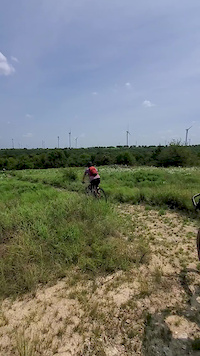
Photos of 4R Ranch Mountain Bike
Videos of 4R Ranch Mountain Bike
0:12 |
220 |
Sep 9, 2020
Recent Trail Reports
| status | trail | date | condition | info | user |
|---|---|---|---|---|---|
| Brambles Mountain Biking Trail | May 9, 2022 @ 1:31pm May 9, 2022 | Ideal | RyanB23 |
Activity Feed
| username | action | type | title | date | |
|---|---|---|---|---|---|
 | Rblair0512 | wishlist | trail | Brambles Mountain Biking Trail | Jun 24, 2022 @ 9:44pm Jun 24, 2022 |
| GTMB | wishlist | trail | Brambles Mountain Biking Trail | May 12, 2022 @ 7:33pm May 12, 2022 |
| RyanB23 | add | report | Brambles Mountain Biking Trail | May 9, 2022 @ 5:26pm May 9, 2022 |
| LDJBaxter | ridden | trail | Brambles Mountain Biking Trail | Apr 19, 2022 @ 10:48am Apr 19, 2022 |
| mrbreadman | wishlist | trail | Brambles Mountain Biking Trail | Mar 21, 2022 @ 9:40pm Mar 21, 2022 |
Recent Comments
| username | type | title | comment | date | |
|---|---|---|---|---|---|
| trail | Fun trail that provides a great workout to... | Mar 19, 2022 @ 2:36pm Mar 19, 2022 |
Nearby Areas
| name | distance | ||||
|---|---|---|---|---|---|
| Lake Murray State Park | 6 | 30 km | |||
| Ray Roberts Lake Johnson Branch Unit | 3 | 2 | 1 | 30.8 km | |
| Ray Roberts Lake Isle De Bois Unit | 2 | 5 | 2 | 34 km | |
| Ray Roberts Greenbelt Corridor | 38.6 km | ||||
| Hartlee Field Mountain Bike Trails | 1 | 38.7 km |
Local Products
Activity Type Stats
| activitytype | trails | distance | descent | descent distance | total vertical | rating | global rank | state rank | photos | reports | routes | ridelogs |
|---|---|---|---|---|---|---|---|---|---|---|---|---|
| Mountain Bike | 1 | 9 miles | 804 ft | 3 miles | 243 ft | #4,222 | #1,896 | 11 | 2 | 45 | ||
| Hike | 1 | 9 miles | 804 ft | 3 miles | 243 ft | #3,507 | #1,756 | 2 | ||||
| Trail Running | 1 | 9 miles | 804 ft | 3 miles | 243 ft | #3,514 | #1,755 | 2 | 1 |
- By Turntex
 TRAILFORKS SMGA & contributors
 - Admins: DORBA
- #40598 - 1,651 views
- 4r ranch activity log | embed map of 4R Ranch mountain bike trails | 4r ranch mountain biking points of interest
Downloading of trail gps tracks in kml & gpx formats is enabled for 4R Ranch.
You must login to download files.