close
Trail Conditions
- Unknown
- Snow Groomed
- Snow Packed
- Snow Covered
- Snow Cover Inadequate
- Freeze/thaw Cycle
- Icy
- Prevalent Mud
- Wet
- Variable
- Ideal
- Dry
- Very Dry
Trail Flow (Ridden Direction)
Trailforks scans users ridelogs to determine the most popular direction each trail is ridden. A good flowing trail network will have most trails flowing in a single direction according to their intension.
The colour categories are based on what percentage of riders are riding a trail in its intended direction.
The colour categories are based on what percentage of riders are riding a trail in its intended direction.
- > 96%
- > 90%
- > 80%
- > 70%
- > 50%
- < 50%
- bi-directional trail
- no data
Trail Last Ridden
Trailforks scans ridelogs to determine the last time a trail was ridden.
- < 2 days
- < 1 week
- < 2 weeks
- < 1 month
- < 6 months
- > 6 months
Trail Ridden Direction
The intended direction a trail should be ridden.
- Downhill Only
- Downhill Primary
- Both Directions
- Uphill Primary
- Uphill Only
- One Direction
Contribute Details
Colors indicate trail is missing specified detail.
- Description
- Photos
- Description & Photos
- Videos
Trail Popularity ?
Trailforks scans ridelogs to determine which trails are ridden the most in the last 9 months.
Trails are compared with nearby trails in the same city region with a possible 25 colour shades.
Think of this as a heatmap, more rides = more kinetic energy = warmer colors.
- most popular
- popular
- less popular
- not popular
ATV/ORV/OHV Filter
Max Vehicle Width
inches
Radar Time
x
Activity Recordings
Trailforks users anonymized public ridelogs from the past 6 months.
- mountain biking recent
- mountain biking (>6 month)
- hiking (1 year)
- moto (1 year)
Activity Recordings
Trailforks users anonymized public skilogs from the past 12 months.
- Downhill Ski
- Backcountry Ski
- Nordic Ski
Jump Magnitude Heatmap
Heatmap of where riders jump on trails. Zoom in to see individual jumps, click circles to view jump details.
Trails Deemphasized
Trails are shown in grey.
Only show trails with NO bikes.
Save the current map location and zoom level as your default home location whenever this page is loaded.
SaveSmall in-town trail network with a variety of riding difficulties.
Primary Trail Type: Cross-Country
eBikes Allowed:
No
Land Status: State Park
 google parking directions
 Activities Click to view
- Mountain Bike
12 trails
- Hike
11 trails
- Trail Running
11 trails
Region Details
- 2
- 1
- 3
- 5
- 1
Region Status
Open as of May 3, 2022Local Trail Association
Stats
- Avg Trail Rating
- Trails (view details)
- 12
- Trails Mountain Bike
- 12
- Trails Hike
- 11
- Trails Trail Running
- 11
- Total Distance
- 9 miles
- Total Descent
- 1,129 ft
- Total Vertical
- 364 ft
- Highest Trailhead
- 3,265 ft
- Reports
- 68
- Photos
- 15
- Ridden Counter
- 576
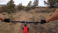
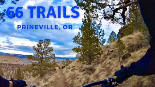
Popular 66 Trails Mountain Biking Trails
Photos of 66 Trails Mountain Bike
trail: The Crossing
94 |
Mar 21, 2021 @ 8:54am
Mar 21, 2021
trail: Rim Trail
151 |
Jun 16, 2019 @ 6:24am
Jun 16, 2019Videos of 66 Trails Mountain Bike

trail: Let 'er Buck
1:20 |
346 |
Nov 6, 2019
trail: The Crossing
2:25 |
105 |
Nov 5, 2019
trail: Rocky Raccoon
8:06 |
44 |
Dec 1, 2021 , Prineville

trail: Brewer's Choice
8:06 |
60 |
Dec 1, 2021 , Prineville

trail: Antiques Roadshow
8:06 |
217 |
Dec 1, 2021 , Prineville

trail: Trashalanche!
8:06 |
43 |
Dec 1, 2021 , Prineville

trail: Rim Trail
8:06 |
87 |
Dec 1, 2021 , Prineville
Recent Trail Reports
| status | trail | date | condition | info | user |
|---|---|---|---|---|---|
| Sporty Berms DH | Feb 5, 2022 @ 10:43pm Feb 5, 2022 | Prevalent Mud | kingdoj1 | ||
| Trashalanche! | Feb 5, 2022 @ 10:42pm Feb 5, 2022 | Prevalent Mud | kingdoj1 | ||
| The Crossing | Feb 5, 2022 @ 10:41pm Feb 5, 2022 | Prevalent Mud | kingdoj1 | ||
| Pebbles | Feb 5, 2022 @ 10:41pm Feb 5, 2022 | Variable | kingdoj1 | ||
| Rim Trail | Feb 5, 2022 @ 10:40pm Feb 5, 2022 | Variable | kingdoj1 | ||
| Antiques Roadshow | Nov 21, 2020 @ 5:17pm Nov 21, 2020 | Ideal | casmith9 | ||
| Let 'er Buck | Nov 21, 2020 @ 5:15pm Nov 21, 2020 | Ideal | casmith9 | ||
| Brewer's Choice | Nov 21, 2020 @ 5:14pm Nov 21, 2020 | Ideal | casmith9 | ||
| 66 Trails - Trail Unknown | Oct 17, 2019 @ 11:51am Oct 17, 2019 | Very Dry | |||
| Seth's Highway | Jul 15, 2019 @ 3:33pm Jul 15, 2019 | Dry | Ambertoomey |
Activity Feed
| username | action | type | title | date | |
|---|---|---|---|---|---|
 | freeride-shawn | wishlist | region | 66 Trails | Jun 1, 2022 @ 6:38pm Jun 1, 2022 |
 | mackerl | vote | trail | Rim Trail | May 11, 2022 @ 3:50pm May 11, 2022 |
| kingdoj1 | add | report | Rim Trail and 4 more | Feb 5, 2022 @ 10:40pm Feb 5, 2022 |
| MLockrem77 | add | video | 66 Trail System | Prineville, Oregon and 4 more | Dec 1, 2021 @ 11:26am Dec 1, 2021 |
| pfchurchill | ridden | trail | Brewer's Choice and 5 more | Oct 10, 2021 @ 7:27am Oct 10, 2021 |
Recent Comments
| username | type | title | comment | date | |
|---|---|---|---|---|---|
 | trail | Lots of rocks, but overall fun trail. | Nov 26, 2018 @ 4:52pm Nov 26, 2018 | ||
| trail | Fun, well-maintained trail. | Nov 26, 2018 @ 4:51pm Nov 26, 2018 |
Nearby Areas
| name | distance | ||||
|---|---|---|---|---|---|
| 66 Trails North | 1 | 1 | 1.6 km | ||
| Barnes Butte | 4 | 5 | 3 | 3.1 km | |
| Radlands | 3 | 2 | 13.4 km | ||
| Gray Butte | 5 | 14.1 km | |||
| Smith Rock | 1 | 6 | 1 | 14.3 km |
Local Products
Activity Type Stats
| activitytype | trails | distance | descent | descent distance | total vertical | rating | global rank | state rank | photos | reports | routes | ridelogs |
|---|---|---|---|---|---|---|---|---|---|---|---|---|
| Mountain Bike | 12 | 9 miles | 1,129 ft | 4 miles | 364 ft | #4,820 | #2,121 | 15 | 63 | 442 | ||
| Hike | 11 | 9 miles | 1,010 ft | 4 miles | 364 ft | #3,702 | #1,824 | 62 | 24 | |||
| Trail Running | 11 | 9 miles | 1,010 ft | 4 miles | 364 ft | #3,717 | #1,825 | 62 | 3 |
- By TravisHolman
 COTA Ochoco Trails & contributors
 - Admins: COTA, TravisHolman, bendtrails, n-skinner, Alexbeard9, johannsdad, aiwetir, Wayfinder, sporty-nordy
- #18075 - 3,344 views
- 66 trails activity log | embed map of 66 Trails mountain bike trails | 66 trails mountain biking points of interest
Downloading of trail gps tracks in kml & gpx formats is enabled for 66 Trails.
You must login to download files.