close
Trail Conditions
- Unknown
- Snow Groomed
- Snow Packed
- Snow Covered
- Snow Cover Inadequate
- Freeze/thaw Cycle
- Icy
- Prevalent Mud
- Wet
- Variable
- Ideal
- Dry
- Very Dry
Trail Flow (Ridden Direction)
Trailforks scans users ridelogs to determine the most popular direction each trail is ridden. A good flowing trail network will have most trails flowing in a single direction according to their intension.
The colour categories are based on what percentage of riders are riding a trail in its intended direction.
The colour categories are based on what percentage of riders are riding a trail in its intended direction.
- > 96%
- > 90%
- > 80%
- > 70%
- > 50%
- < 50%
- bi-directional trail
- no data
Trail Last Ridden
Trailforks scans ridelogs to determine the last time a trail was ridden.
- < 2 days
- < 1 week
- < 2 weeks
- < 1 month
- < 6 months
- > 6 months
Trail Ridden Direction
The intended direction a trail should be ridden.
- Downhill Only
- Downhill Primary
- Both Directions
- Uphill Primary
- Uphill Only
- One Direction
Contribute Details
Colors indicate trail is missing specified detail.
- Description
- Photos
- Description & Photos
- Videos
Trail Popularity ?
Trailforks scans ridelogs to determine which trails are ridden the most in the last 9 months.
Trails are compared with nearby trails in the same city region with a possible 25 colour shades.
Think of this as a heatmap, more rides = more kinetic energy = warmer colors.
- most popular
- popular
- less popular
- not popular
ATV/ORV/OHV Filter
Max Vehicle Width
inches
Radar Time
x
Activity Recordings
Trailforks users anonymized public ridelogs from the past 6 months.
- mountain biking recent
- mountain biking (>6 month)
- hiking (1 year)
- moto (1 year)
Activity Recordings
Trailforks users anonymized public skilogs from the past 12 months.
- Downhill Ski
- Backcountry Ski
- Nordic Ski
Jump Magnitude Heatmap
Heatmap of where riders jump on trails. Zoom in to see individual jumps, click circles to view jump details.
Trails Deemphasized
Trails are shown in grey.
Only show trails with NO bikes.
Save the current map location and zoom level as your default home location whenever this page is loaded.
Save!!ATENTION!!! Trails are no longer accessible by car. The forestal road has been blocked to all traffic. Please get in contact with City Hall: info@sanlorenzodeelescorial.org , if you are interested in getting access permission. All kind of biking is legal in the area.
The mountain where the village of San Lorenzo de el Escorial lies. Abantos is a National Park, please respect the nature and remain on the established trails. Your aim is to leave the área the same way you found it, but of course, with the rad feeling your rode it.
La montaña donde se sitúa San Lorenzo de el Escorial.
Primary Trail Type: All-Mountain & Downhill
Land Status: National Forest
 google parking directions
 Access Info:
The car park under the Felipe II center.
El aparcamiento debajo del centro Felipe II
El aparcamiento debajo del centro Felipe II
This region uses the Uk/Euro style trail grading system.
Activities Click to view
- Mountain Bike
57 trails
- E-Bike
46 trails
- Hike
50 trails
- Trail Running
49 trails
Region Details
- 23
- 3
- 19
- 9
Region Status
Caution as of Jan 3, 2022Stats
- Avg Trail Rating
- Trails (view details)
- 54
- Trails Mountain Bike
- 57
- Trails E-Bike
- 46
- Trails Hike
- 50
- Trails Trail Running
- 49
- Total Distance
- 49 miles
- Total Descent
- 14,384 ft
- Total Vertical
- 2,857 ft
- Highest Trailhead
- 5,755 ft
- Reports
- 62
- Photos
- 14
- Ridden Counter
- 816
Popular Abantos Mountain Biking Trails
Photos of Abantos Mountain Bike
trail: Puerto de Abantos
14 |
Jun 3, 2022 @ 9:27am
Jun 3, 2022
trail: Pozos de Nieve
2 |
Jun 3, 2022 @ 9:27am
Jun 3, 2022
trail: La Solana Cortafuegos Alta
1 |
Jun 3, 2022 @ 9:27am
Jun 3, 2022
trail: La Solana Cortafuegos Alta
0 |
Jun 3, 2022 @ 9:27am
Jun 3, 2022
trail: La Solana Cortafuegos Alta
0 |
Jun 3, 2022 @ 9:27am
Jun 3, 2022
trail: Solana del Barrancón
2 |
Jun 3, 2022 @ 9:27am
Jun 3, 2022
trail: Los Vascos I
122 |
Jan 15, 2020 @ 2:26pm
Jan 15, 2020
trail: Los Corzos
62 |
Jan 15, 2020 @ 2:26pm
Jan 15, 2020Videos of Abantos Mountain Bike
youtuber
![ESCORIAL EXTREME ⛰️ | Buscando senderos...]()
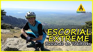
trail: Los Vascos II
7:19 |
18 |
May 23, 2022 , San Lorenzo del Escorial
youtuber
![ESCORIAL EXTREME ⛰️ | Buscando senderos...]()

trail: Los Corzos
7:19 |
21 |
May 23, 2022 , San Lorenzo del Escorial


trail: Del Cielo Alta
13:51 |
57 |
Jan 16, 2022 , San Lorenzo del Escorial

trail: Solana de Enmedio
13:51 |
45 |
Jan 16, 2022 , San Lorenzo del Escorial
trail: Los Vascos II
8:55 |
62 |
Sep 2, 2021 , San Lorenzo del Escorial
Recent Trail Reports
| status | trail | date | condition | info | user |
|---|---|---|---|---|---|
| Los Vascos I | May 5, 2022 @ 1:17pm May 5, 2022 | Ideal | kobino | ||
| Los Vascos II | May 5, 2022 @ 1:17pm May 5, 2022 | Ideal | kobino | ||
| Cerro de la Cabeza | Feb 13, 2022 @ 9:41am Feb 13, 2022 | Unknown | Pablice | ||
| Los Corzos | Feb 13, 2022 @ 2:01am Feb 13, 2022 | Dry | Pablice | ||
| Paralela | Feb 13, 2022 @ 2:01am Feb 13, 2022 | Dry | Pablice | ||
| Puerta Verde por Cebadillas | Feb 13, 2022 @ 12:06am Feb 13, 2022 | Dry | Jliarte | ||
| Las Zetas | Feb 5, 2022 @ 12:17am Feb 5, 2022 | Ideal | ElDany | ||
| La Fuente | Oct 3, 2019 @ 11:58pm Oct 3, 2019 | Very Dry | Ingmerino | ||
| Del Cielo Alta | May 7, 2017 @ 4:31am May 7, 2017 | Variable | twistspain |
Activity Feed
| username | action | type | title | date | |
|---|---|---|---|---|---|
 | not-really | add | trail | Hontanillo and 2 more | Jun 27, 2022 @ 12:51pm Jun 27, 2022 |
| not-really | add | trail | Los Corzitos | Jun 26, 2022 @ 12:50am Jun 26, 2022 |
| not-really | comment | trail | La Solana Cortafuegos Alta and 1 more | Jun 24, 2022 @ 8:56am Jun 24, 2022 |
| not-really | vote | trail | Pozos de Nieve and 2 more | Jun 24, 2022 @ 8:54am Jun 24, 2022 |
| not-really | add | photo | at Puerto de Abantos in San Lorenzo del Escorial, Spain and 5 more | Jun 3, 2022 @ 9:29am Jun 3, 2022 |
Recent Comments
| username | type | title | comment | date | |
|---|---|---|---|---|---|
| trail | Aunque está asfaltada, esta cerrada al... | Jun 24, 2022 @ 8:58am Jun 24, 2022 | ||
| trail | Es una manera rápida de ascender hacia el... | Jun 24, 2022 @ 8:56am Jun 24, 2022 | ||
 | trail | Del primer tramo casi ni te enteras, es una... | May 9, 2019 @ 3:54am May 9, 2019 | ||
| trail | ENGLISH-SPANISH It is a harder trail than it... | May 9, 2019 @ 3:20am May 9, 2019 | ||
| trail | A mi juicio más bonita subiendo que bajando.... | Oct 22, 2018 @ 4:12am Oct 22, 2018 |
Nearby Areas
| name | distance | ||||
|---|---|---|---|---|---|
| Embalse de Valmayor | 8 | 6.5 km | |||
| La Jarosa | 5 | 17 | 6.7 km | ||
| El Espinar | 10 | 29 | 8.6 km | ||
| Cerro del telegrafo | 6 | 4 | 10.9 km | ||
| Hoyo de Manzanares | 14 | 10 | 2 | 11.9 km |
Activity Type Stats
| activitytype | trails | distance | descent | descent distance | total vertical | rating | global rank | state rank | photos | reports | routes | ridelogs |
|---|---|---|---|---|---|---|---|---|---|---|---|---|
| Mountain Bike | 57 | 49 miles | 14,383 ft | 26 miles | 2,858 ft | #4,869 | #145 | 14 | 62 | 929 | ||
| E-Bike | 46 | 39 miles | 9,491 ft | 20 miles | 2,858 ft | #2,299 | #159 | 60 | 128 | |||
| Hike | 50 | 45 miles | 13,035 ft | 24 miles | 2,858 ft | #3,973 | #117 | 60 | 42 | |||
| Trail Running | 49 | 44 miles | 12,687 ft | 23 miles | 2,858 ft | #3,985 | #117 | 60 | 5 |
- By Irosideways & contributors
- Admins: apply
- #12538 - 2,832 views
- abantos activity log | embed map of Abantos mountain bike trails | abantos mountain biking points of interest
Downloading of trail gps tracks in kml & gpx formats is enabled for Abantos.
You must login to download files.