close
Trail Conditions
- Unknown
- Snow Groomed
- Snow Packed
- Snow Covered
- Snow Cover Inadequate
- Freeze/thaw Cycle
- Icy
- Prevalent Mud
- Wet
- Variable
- Ideal
- Dry
- Very Dry
Trail Flow (Ridden Direction)
Trailforks scans users ridelogs to determine the most popular direction each trail is ridden. A good flowing trail network will have most trails flowing in a single direction according to their intension.
The colour categories are based on what percentage of riders are riding a trail in its intended direction.
The colour categories are based on what percentage of riders are riding a trail in its intended direction.
- > 96%
- > 90%
- > 80%
- > 70%
- > 50%
- < 50%
- bi-directional trail
- no data
Trail Last Ridden
Trailforks scans ridelogs to determine the last time a trail was ridden.
- < 2 days
- < 1 week
- < 2 weeks
- < 1 month
- < 6 months
- > 6 months
Trail Ridden Direction
The intended direction a trail should be ridden.
- Downhill Only
- Downhill Primary
- Both Directions
- Uphill Primary
- Uphill Only
- One Direction
Contribute Details
Colors indicate trail is missing specified detail.
- Description
- Photos
- Description & Photos
- Videos
Trail Popularity ?
Trailforks scans ridelogs to determine which trails are ridden the most in the last 9 months.
Trails are compared with nearby trails in the same city region with a possible 25 colour shades.
Think of this as a heatmap, more rides = more kinetic energy = warmer colors.
- most popular
- popular
- less popular
- not popular
ATV/ORV/OHV Filter
Max Vehicle Width
inches
Radar Time
x
Activity Recordings
Trailforks users anonymized public ridelogs from the past 6 months.
- mountain biking recent
- mountain biking (>6 month)
- hiking (1 year)
- moto (1 year)
Activity Recordings
Trailforks users anonymized public skilogs from the past 12 months.
- Downhill Ski
- Backcountry Ski
- Nordic Ski
Jump Magnitude Heatmap
Heatmap of where riders jump on trails. Zoom in to see individual jumps, click circles to view jump details.
Trails Deemphasized
Trails are shown in grey.
Only show trails with NO bikes.
Save the current map location and zoom level as your default home location whenever this page is loaded.
SaveThe Future Hub
Abenaki is the town-run, rope-tow serviced, ski area in Wolfeboro. The Friend's of Abenaki and the Town have allowed Wolfeboro Singletrack Alliance to use the lodge during the summer. It's a great place to park and will eventually be home to more bike related amenities.
Along with the lodge, there are over 200 acres of land that will be used to build out new singletrack trails and a pump track.
Skill Level: Expert
Parking: 390 Pine Hill Rd, Wolfeboro, NH 03894
Primary Trail Type: Cross-Country
eBikes Allowed:
No
Land Status: City Managed
 google parking directions
Links
Activities Click to view
- Mountain Bike
17 trails
- Hike
17 trails
- Trail Running
17 trails
- Snowshoe
0 trails
- Downhill Ski
0 trails
- Nordic Ski
9 trails
Region Details
- 15
- 2
Region Status
Open as of Apr 29, 2021Stats
- Avg Trail Rating
- Trails (view details)
- 24
- Trails Mountain Bike
- 17
- Trails Hike
- 17
- Trails Trail Running
- 17
- Trails Nordic Ski
- 9
- Total Distance
- 17 miles
- Total Descent
- 2,464 ft
- Total Vertical
- 313 ft
- Highest Trailhead
- 851 ft
- Reports
- 10
- Photos
- 2
- Ridden Counter
- 675
Popular Abenaki Trail Network Mountain Biking Trails
Abenaki Trail Network Mountain Bike Routes
| title | rating | distance |
|---|---|---|
| Abenaki From Downtown | 8 miles | |
| Summer Race Series #3 Sport and Expert race | 4 miles |
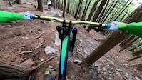
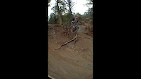
Photos of Abenaki Trail Network Mountain Bike
trail: Grand View
5 |
Jun 20, 2022 @ 10:14am
Jun 20, 2022
trail: Lower Bog Hill Run
73 |
Oct 16, 2021 @ 6:21am
Oct 16, 2021


Recent Trail Reports
| status | trail | date | condition | info | user |
|---|---|---|---|---|---|
| Tomahawk | May 8, 2022 @ 5:36am May 8, 2022 | Dry | drudymeyer | ||
| Blackeye | Jul 5, 2021 @ 4:39pm Jul 5, 2021 | Ideal | agehl310 | ||
| Upper Bog Hill Run | Jul 3, 2021 @ 10:51am Jul 3, 2021 | Dry | Twhitezzz |
Activity Feed
| username | action | type | title | date | |
|---|---|---|---|---|---|
 | granitegrowler | add | photo | in My City | Jun 20, 2022 @ 10:14am Jun 20, 2022 |
| mehmeddiken | wishlist | route | Abenaki From Downtown | May 28, 2022 @ 10:25am May 28, 2022 |
| mattsolar | wishlist | trail | Blackeye | May 26, 2022 @ 7:16am May 26, 2022 |
| drudymeyer | add | report | Tomahawk | May 8, 2022 @ 5:36am May 8, 2022 |
 | CaliGoldRush | wishlist | trail | Blackeye | May 2, 2022 @ 11:51am May 2, 2022 |
Recent Comments
| username | type | title | comment | date | |
|---|---|---|---|---|---|
| trail | Very loose gravel makes for a difficult ride... | May 26, 2021 @ 7:04am May 26, 2021 | ||
| trail | Flowy more mellow downhill with two big ~5-6ft... | May 26, 2021 @ 7:03am May 26, 2021 | ||
| trail | Very steep, loamy downhill with a few rock... | May 26, 2021 @ 7:00am May 26, 2021 |
Nearby Areas
| name | distance | ||||
|---|---|---|---|---|---|
| Sewall Woods Trail Network | 11 | 11 | 5 | 1.5 km | |
| Fernald Station Trail Network | 7 | 6 | 3.7 km | ||
| Alton Trail Network | 14 | 39 | 32 | 11 | 6.7 km |
| Gunstock Mountain Resort | 3 | 1 | 4 | 1 | 7.7 km |
| Belknap Range Trails | 5 | 26 | 8 | 9 km |
Activity Type Stats
| activitytype | trails | distance | descent | descent distance | total vertical | rating | global rank | state rank | photos | reports | routes | ridelogs |
|---|---|---|---|---|---|---|---|---|---|---|---|---|
| Mountain Bike | 17 | 12 miles | 1,906 ft | 4 miles | 312 ft | #8,018 | #3,368 | 2 | 10 | 2 | 355 | |
| Hike | 17 | 12 miles | 1,906 ft | 4 miles | 312 ft | #7,062 | #3,213 | 8 | 2 | |||
| Trail Running | 17 | 12 miles | 1,906 ft | 4 miles | 312 ft | #7,053 | #3,204 | 8 | 7 | |||
| Nordic Ski | 9 | 6 miles | 584 ft | 3 miles | 276 ft | #509 | #304 | 2 | 12 |
- By WillieJacobsz
 TRAILFORKS NEMBA & contributors
 - Admins: CNH NEMBA, WSA
- #28633 - 2,003 views
- abenaki trail network activity log | embed map of Abenaki Trail Network mountain bike trails | abenaki trail network mountain biking points of interest polygons
Downloading of trail gps tracks in kml & gpx formats is enabled for Abenaki Trail Network.
You must login to download files.