close
Trail Conditions
- Unknown
- Snow Groomed
- Snow Packed
- Snow Covered
- Snow Cover Inadequate
- Freeze/thaw Cycle
- Icy
- Prevalent Mud
- Wet
- Variable
- Ideal
- Dry
- Very Dry
Trail Flow (Ridden Direction)
Trailforks scans users ridelogs to determine the most popular direction each trail is ridden. A good flowing trail network will have most trails flowing in a single direction according to their intension.
The colour categories are based on what percentage of riders are riding a trail in its intended direction.
The colour categories are based on what percentage of riders are riding a trail in its intended direction.
- > 96%
- > 90%
- > 80%
- > 70%
- > 50%
- < 50%
- bi-directional trail
- no data
Trail Last Ridden
Trailforks scans ridelogs to determine the last time a trail was ridden.
- < 2 days
- < 1 week
- < 2 weeks
- < 1 month
- < 6 months
- > 6 months
Trail Ridden Direction
The intended direction a trail should be ridden.
- Downhill Only
- Downhill Primary
- Both Directions
- Uphill Primary
- Uphill Only
- One Direction
Contribute Details
Colors indicate trail is missing specified detail.
- Description
- Photos
- Description & Photos
- Videos
Trail Popularity ?
Trailforks scans ridelogs to determine which trails are ridden the most in the last 9 months.
Trails are compared with nearby trails in the same city region with a possible 25 colour shades.
Think of this as a heatmap, more rides = more kinetic energy = warmer colors.
- most popular
- popular
- less popular
- not popular
ATV/ORV/OHV Filter
Max Vehicle Width
inches
Radar Time
x
Activity Recordings
Trailforks users anonymized public ridelogs from the past 6 months.
- mountain biking recent
- mountain biking (>6 month)
- hiking (1 year)
- moto (1 year)
Activity Recordings
Trailforks users anonymized public skilogs from the past 12 months.
- Downhill Ski
- Backcountry Ski
- Nordic Ski
Jump Magnitude Heatmap
Heatmap of where riders jump on trails. Zoom in to see individual jumps, click circles to view jump details.
Trails Deemphasized
Trails are shown in grey.
Only show trails with NO bikes.
Save the current map location and zoom level as your default home location whenever this page is loaded.
SaveActivities Click to view
- Mountain Bike
92 trails
- E-Bike
92 trails
- Hike
93 trails
- Trail Running
93 trails
Region Details
- 53
- 8
- 15
- 13
- 3
Region Status
Open as of Jul 2, 2022Stats
- Avg Trail Rating
- Trails (view details)
- 93
- Trails Mountain Bike
- 92
- Trails E-Bike
- 92
- Trails Hike
- 93
- Trails Trail Running
- 93
- Trails Horse
- 3
- Total Distance
- 153 miles
- Total Descent Distance
- 105 miles
- Total Descent
- 52,843 ft
- Total Vertical
- 7,510 ft
- Highest Trailhead
- 7,512 ft
- Reports
- 7
- Photos
- 34
- Ridden Counter
- 64
Popular Abona Mountain Biking Trails
Abona Mountain Bike Routes
| title | rating | distance |
|---|---|---|
| XC Golf Del Sur | 17 miles |
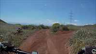
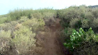
Photos of Abona Mountain Bike
trail: Hermano Pedro
5 |
Apr 24, 2022 @ 9:50am
Apr 24, 2022
trail: Hermano Pedro
5 |
Apr 24, 2022 @ 9:50am
Apr 24, 2022
trail: Barranco los Balos
4 |
Apr 24, 2022 @ 9:48am
Apr 24, 2022
trail: Saltadero
13 |
Apr 24, 2022 @ 2:29am
Apr 24, 2022
trail: Jama
10 |
Apr 22, 2022 @ 9:15am
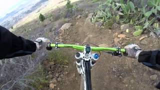
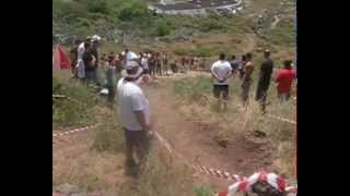
Apr 22, 2022Videos of Abona Mountain Bike
trail: Piconera
2:56 |
6 |
Apr 28, 2016
trail: Jama
10:56 |
68 |
Aug 12, 2013

trail: Jama
0:47 |
98 |
Apr 17, 2011
trail: Jama
11:42 |
20 |
Apr 23, 2022 , Granadilla

trail: Parapentes
11:42 |
15 |
Apr 23, 2022 , Granadilla

trail: Trevejos
11:42 |
26 |
Apr 23, 2022 , Granadilla
trail: Jama
9:07 |
41 |
Apr 22, 2022 , Granadilla
Recent Trail Reports
| status | trail | date | condition | info | user |
|---|---|---|---|---|---|
| Tunel bajo TF-1- Los Cardones | Jan 18, 2022 @ 3:55am Jan 18, 2022 | Ideal | coticj | ||
| Hermano Pedro | Jan 18, 2022 @ 3:55am Jan 18, 2022 | Ideal | coticj | ||
| Cactus | Nov 30, 2021 @ 4:46am Nov 30, 2021 | Variable | Pier82go | ||
| Los Cristianos - Montaña de Guaza | Nov 20, 2021 @ 3:10am Nov 20, 2021 | Dry | Pierewaaier | ||
| Fuente Agria | Oct 28, 2021 @ 2:45am Oct 28, 2021 | Dry | Bruno52 | ||
| San Miguel de Abona - Los Abrigos | Aug 2, 2021 @ 1:42am Aug 2, 2021 | Dry | kai-bcn |
Activity Feed
| username | action | type | title | date | |
|---|---|---|---|---|---|
 | not-really | update | trail | El Contador and 7 more | Jun 28, 2022 @ 10:20am Jun 28, 2022 |
| not-really | add | trail | Barranco El Atajo and 2 more | Jun 25, 2022 @ 7:38am Jun 25, 2022 |
 | Danny69 | wishlist | trail | General de Arico | Jun 23, 2022 @ 1:19pm Jun 23, 2022 |
| not-really | add | trail | Paisaje Lunar | Apr 26, 2022 @ 12:45pm Apr 26, 2022 |
| not-really | update | trail | Hoyo de Los Morteros | Apr 26, 2022 @ 6:29am Apr 26, 2022 |
Nearby Areas
| name | distance | ||||
|---|---|---|---|---|---|
| Parque Nacional del Teide | 2 | 10 km | |||
| Adeje | 1 | 2 | 13.2 km | ||
| Valle De La Orotava | 10 | 21 | 15.3 km | ||
| Valle de Güímar | 2 | 2 | 15.6 km | ||
| Valle de Icod | 16.4 km |
Activity Type Stats
| activitytype | trails | distance | descent | descent distance | total vertical | rating | global rank | state rank | photos | reports | routes | ridelogs |
|---|---|---|---|---|---|---|---|---|---|---|---|---|
| Mountain Bike | 92 | 152 miles | 52,841 ft | 105 miles | 7,510 ft | #12,060 | #421 | 34 | 7 | 1 | 22 | |
| E-Bike | 92 | 152 miles | 52,841 ft | 105 miles | 7,510 ft | #4,297 | #348 | 5 | 1 | 4 | ||
| Hike | 93 | 153 miles | 52,841 ft | 105 miles | 7,510 ft | #11,068 | #382 | 6 | 6 | |||
| Trail Running | 93 | 153 miles | 52,841 ft | 105 miles | 7,510 ft | #11,005 | #381 | 6 | ||||
| Horse | 3 | 15 miles | 2,018 ft | 7 miles | 6,352 ft |
- By not-really
 & contributors
 - Admins: not-really
- #50480 - 162 views
- abona activity log | embed map of Abona mountain bike trails | abona mountain biking points of interest
Downloading of trail gps tracks in kml & gpx formats is enabled for Abona.
You must login to download files.