close
Trail Conditions
- Unknown
- Snow Groomed
- Snow Packed
- Snow Covered
- Snow Cover Inadequate
- Freeze/thaw Cycle
- Icy
- Prevalent Mud
- Wet
- Variable
- Ideal
- Dry
- Very Dry
Trail Flow (Ridden Direction)
Trailforks scans users ridelogs to determine the most popular direction each trail is ridden. A good flowing trail network will have most trails flowing in a single direction according to their intension.
The colour categories are based on what percentage of riders are riding a trail in its intended direction.
The colour categories are based on what percentage of riders are riding a trail in its intended direction.
- > 96%
- > 90%
- > 80%
- > 70%
- > 50%
- < 50%
- bi-directional trail
- no data
Trail Last Ridden
Trailforks scans ridelogs to determine the last time a trail was ridden.
- < 2 days
- < 1 week
- < 2 weeks
- < 1 month
- < 6 months
- > 6 months
Trail Ridden Direction
The intended direction a trail should be ridden.
- Downhill Only
- Downhill Primary
- Both Directions
- Uphill Primary
- Uphill Only
- One Direction
Contribute Details
Colors indicate trail is missing specified detail.
- Description
- Photos
- Description & Photos
- Videos
Trail Popularity ?
Trailforks scans ridelogs to determine which trails are ridden the most in the last 9 months.
Trails are compared with nearby trails in the same city region with a possible 25 colour shades.
Think of this as a heatmap, more rides = more kinetic energy = warmer colors.
- most popular
- popular
- less popular
- not popular
ATV/ORV/OHV Filter
Max Vehicle Width
inches
Radar Time
x
Activity Recordings
Trailforks users anonymized public ridelogs from the past 6 months.
- mountain biking recent
- mountain biking (>6 month)
- hiking (1 year)
- moto (1 year)
Activity Recordings
Trailforks users anonymized public skilogs from the past 12 months.
- Downhill Ski
- Backcountry Ski
- Nordic Ski
Jump Magnitude Heatmap
Heatmap of where riders jump on trails. Zoom in to see individual jumps, click circles to view jump details.
Trails Deemphasized
Trails are shown in grey.
Only show trails with NO bikes.
Save the current map location and zoom level as your default home location whenever this page is loaded.
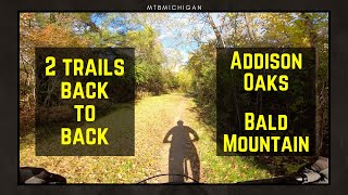
SaveAddison Oaks is a scenic 1,140-acre park in northeast Oakland County with two lakes and spring-fed ponds containing fast, flowing, fun mountain bike trails
Primary Trail Type: Cross-Country
eBikes Allowed:
No
Land Status: Municipal Park
 google parking directions
Links
Files
Region Supporters & Maintainers
- Roger Class JrMaintainer
Activities Click to view
- Mountain Bike
1 trails
- Hike
1 trails
- Trail Running
1 trails
Region Details
- 1
Region Status
Caution as of Jun 10, 2022Stats
- Avg Trail Rating
- Trails (view details)
- 1
- Trails Mountain Bike
- 1
- Trails Hike
- 1
- Trails Trail Running
- 1
- Total Distance
- 6 miles
- Total Descent
- 734 ft
- Total Vertical
- 113 ft
- Highest Trailhead
- 1,087 ft
- Reports
- 61
- Photos
- 4
- Ridden Counter
- 369
Popular Addison Oaks County Park Mountain Biking Trails
| status | title | difficulty | rating |
|---|---|---|---|
| Addison Oaks Loop |
Photos of Addison Oaks County Park Mountain Bike
trail: Addison Oaks Loop
50 |
Aug 6, 2020 @ 7:06pm
Aug 6, 2020
trail: Addison Oaks Loop
51 |
Aug 6, 2020 @ 7:06pm
Aug 6, 2020
trail: Addison Oaks Loop
148 |
May 2, 2018 @ 12:43am
May 2, 2018
trail: Addison Oaks Loop
129 |
May 2, 2018 @ 12:43am
May 2, 2018Videos of Addison Oaks County Park Mountain Bike
trail: Addison Oaks Loop
17:24 |
402 |
May 9, 2020 , Leonard
youtuber
![A Rylo 360 Review - Not quite ready for...]()

trail: Addison Oaks Loop
4:36 |
486 |
Oct 15, 2018 , Leonard

trail: Addison Oaks Loop
13:01 |
695 |
Aug 22, 2018 , Leonard
Recent Trail Reports
| status | trail | date | condition | info | user |
|---|---|---|---|---|---|
| Addison Oaks Loop | Jun 24, 2022 @ 1:30pm Jun 24, 2022 | Dry | Kz44tz |
Activity Feed
| username | action | type | title | date | |
|---|---|---|---|---|---|
 | mhaenni2 | wishlist | trail | Addison Oaks Loop | Jul 1, 2022 @ 10:47am Jul 1, 2022 |
 | makemann | wishlist | region | Addison Oaks County Park | Jun 28, 2022 @ 12:02pm Jun 28, 2022 |
| Kz44tz | add | report | Addison Oaks Loop | Jun 24, 2022 @ 4:08pm Jun 24, 2022 |
| Mykal2 | wishlist | trail | Addison Oaks Loop | Jun 13, 2022 @ 5:29pm Jun 13, 2022 |
| Kz44tz | add | report | Addison Oaks Loop | Jun 10, 2022 @ 12:03pm Jun 10, 2022 |
Recent Comments
| username | type | title | comment | date | |
|---|---|---|---|---|---|
| report | Thanks for the report. Keep it up! | Aug 9, 2020 @ 8:47am Aug 9, 2020 | ||
| trail | Nice trail, flowy in spots, definitely not too... | Jul 18, 2020 @ 2:24pm Jul 18, 2020 | ||
| trail | Beautiful trail, nothing too technical watch... | Apr 24, 2020 @ 1:03pm Apr 24, 2020 |
Nearby Areas
| name | distance | ||||
|---|---|---|---|---|---|
| Bald Mountain Recreation Area (North) | 6 | 2 | 2.2 km | ||
| Lake Orion High School Trail | 1 | 4.8 km | |||
| Bald Mountain Recreation Area (South) | 7 | 2 | 4.9 km | ||
| Stony Creek Metropark | 7 | 3 | 2 | 6.5 km | |
| Orion Oaks County Park | 11 | 7.3 km |
Activity Type Stats
| activitytype | trails | distance | descent | descent distance | total vertical | rating | global rank | state rank | photos | reports | routes | ridelogs |
|---|---|---|---|---|---|---|---|---|---|---|---|---|
| Mountain Bike | 1 | 6 miles | 735 ft | 2 miles | 112 ft | #2,609 | #1,310 | 4 | 61 | 2,897 | ||
| Hike | 1 | 6 miles | 735 ft | 2 miles | 112 ft | #2,041 | #1,172 | 61 | 6 | |||
| Trail Running | 1 | 6 miles | 735 ft | 2 miles | 112 ft | #2,046 | #1,171 | 61 | 1 |
- By markholloway
 Trailforks & contributors
 - Admins: apply
- #11251 - 4,317 views
- addison oaks county park activity log | embed map of Addison Oaks County Park mountain bike trails | addison oaks county park mountain biking points of interest
Downloading of trail gps tracks in kml & gpx formats is enabled for Addison Oaks County Park.
You must login to download files.