close
Trail Conditions
- Unknown
- Snow Groomed
- Snow Packed
- Snow Covered
- Snow Cover Inadequate
- Freeze/thaw Cycle
- Icy
- Prevalent Mud
- Wet
- Variable
- Ideal
- Dry
- Very Dry
Trail Flow (Ridden Direction)
Trailforks scans users ridelogs to determine the most popular direction each trail is ridden. A good flowing trail network will have most trails flowing in a single direction according to their intension.
The colour categories are based on what percentage of riders are riding a trail in its intended direction.
The colour categories are based on what percentage of riders are riding a trail in its intended direction.
- > 96%
- > 90%
- > 80%
- > 70%
- > 50%
- < 50%
- bi-directional trail
- no data
Trail Last Ridden
Trailforks scans ridelogs to determine the last time a trail was ridden.
- < 2 days
- < 1 week
- < 2 weeks
- < 1 month
- < 6 months
- > 6 months
Trail Ridden Direction
The intended direction a trail should be ridden.
- Downhill Only
- Downhill Primary
- Both Directions
- Uphill Primary
- Uphill Only
- One Direction
Contribute Details
Colors indicate trail is missing specified detail.
- Description
- Photos
- Description & Photos
- Videos
Trail Popularity ?
Trailforks scans ridelogs to determine which trails are ridden the most in the last 9 months.
Trails are compared with nearby trails in the same city region with a possible 25 colour shades.
Think of this as a heatmap, more rides = more kinetic energy = warmer colors.
- most popular
- popular
- less popular
- not popular
ATV/ORV/OHV Filter
Max Vehicle Width
inches
Radar Time
x
Activity Recordings
Trailforks users anonymized public ridelogs from the past 6 months.
- mountain biking recent
- mountain biking (>6 month)
- hiking (1 year)
- moto (1 year)
Activity Recordings
Trailforks users anonymized public skilogs from the past 12 months.
- Downhill Ski
- Backcountry Ski
- Nordic Ski
Jump Magnitude Heatmap
Heatmap of where riders jump on trails. Zoom in to see individual jumps, click circles to view jump details.
Trails Deemphasized
Trails are shown in grey.
Only show trails with NO bikes.
Save the current map location and zoom level as your default home location whenever this page is loaded.
Save
No description for Air Force Academy has been added yet!
Login or register to submit one.
 google parking directions
Primary Trail Type: Cross-Country
Land Status: Private Property
google parking directions Activities Click to view
- Mountain Bike
7 trails
- Hike
10 trails
- Trail Running
10 trails
Region Details
- 3
- 1
- 3
Region Status
Open as of Apr 18, 2022Stats
- Avg Trail Rating
- Trails (view details)
- 10
- Trails Mountain Bike
- 7
- Trails Hike
- 10
- Trails Trail Running
- 10
- Total Distance
- 24 miles
- Total Descent
- 4,357 ft
- Total Vertical
- 2,725 ft
- Highest Trailhead
- 9,372 ft
- Reports
- 65
- Photos
- 14
- Ridden Counter
- 911
Popular Air Force Academy Mountain Biking Trails
| status | title | difficulty | rating |
|---|---|---|---|
| Falcon Loop | |||
| Alt. Line | |||
| B-52 Trail | |||
| Stanley Canyon | |||
| Forest Road | |||
| Stanley Canyon (Upper) | |||
| Forest Road |
Photos of Air Force Academy Mountain Bike
trail: B-52 Trail
38 |
Jun 25, 2020 @ 12:36pm
Jun 25, 2020
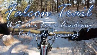
trail: Falcon Loop
168 |
Sep 29, 2019 @ 10:12am
Sep 29, 2019
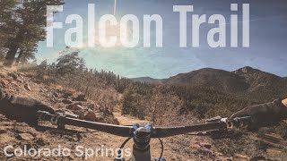
trail: Falcon Loop
190 |
Jul 8, 2019 @ 8:04am
Jul 8, 2019
trail: Falcon Loop
167 |
Jul 8, 2019 @ 8:04am
Jul 8, 2019
trail: Falcon Loop
188 |
Apr 11, 2019 @ 8:50pm
Apr 11, 2019
trail: Falcon Loop
196 |
Apr 11, 2019 @ 8:48pm
Apr 11, 2019
trail: Falcon Loop
198 |
Nov 30, 2018 @ 8:56am
Nov 30, 2018
trail: Falcon Loop
179 |
Nov 30, 2018 @ 8:56am
Nov 30, 2018Videos of Air Force Academy Mountain Bike
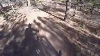
trail: Falcon Loop
9:47 |
276 |
Dec 6, 2020 , Colorado Springs
trail: Falcon Loop
6:11 |
263 |
Nov 21, 2020 , Colorado Springs
youtuber
![Mountain Biking Falcon Trail At The Air Force...]()
trail: Falcon Loop
683 |
Nov 22, 2017 , Colorado Springs

trail: Falcon Loop
813 |
Jul 20, 2017 , Colorado Springs
trail: Falcon Loop
1012 |
Dec 23, 2015 , Colorado Springs
Recent Trail Reports
| status | trail | date | condition | info | user |
|---|---|---|---|---|---|
| Falcon Loop | Jul 5, 2022 @ 7:57am 19 hours | Dry | Wloganb | ||
| Alt. Line | Jun 14, 2022 @ 10:08am Jun 14, 2022 | Dry | Bradvieira | ||
| B-52 Trail | Apr 18, 2022 @ 8:43am Apr 18, 2022 | Ideal | hotpeper |
Activity Feed
| username | action | type | title | date | |
|---|---|---|---|---|---|
 | Wloganb | add | report | Falcon Loop | Jul 5, 2022 @ 4:43pm 10 hours |
 | wv67vRP | ridden | trail | Alt. Line | Jul 2, 2022 @ 1:36pm Jul 2, 2022 |
| Ae24 | wishlist | region | Air Force Academy | Jul 1, 2022 @ 9:30pm Jul 1, 2022 |
| CORunner93 | ridden | trail | Falcon Loop | Jun 20, 2022 @ 5:57pm Jun 20, 2022 |
| Watmatt00 | wishlist | trail | Falcon Loop | Jun 17, 2022 @ 1:42pm Jun 17, 2022 |
Recent Comments
| username | type | title | comment | date | |
|---|---|---|---|---|---|
| trail | Open to public during visiting hours as of 1/17/21 | Jan 17, 2022 @ 1:32pm Jan 17, 2022 | ||
| report | Also, some trail work being done at the... | Oct 21, 2021 @ 7:38pm Oct 21, 2021 | ||
| trail | Closed to non-military for hiking or biking... | Jun 5, 2021 @ 10:22am Jun 5, 2021 | ||
 | trail | Still closed to the public due to COVID19.... | May 16, 2021 @ 5:20pm May 16, 2021 | ||
| trail | Great trail! Some technical parts some places... | Jun 25, 2020 @ 5:51pm Jun 25, 2020 |
Nearby Areas
| name | distance | ||||
|---|---|---|---|---|---|
| Blodgett Peak Open Space | 5 | 5 | 1 | 3.3 km | |
| Woodmen Valley Park | 3 | 1 | 3.4 km | ||
| Ute Valley Park | 13 | 15 | 8 | 5.2 km | |
| Rampart Reservoir | 2 | 1 | 6.4 km | ||
| Farish Recreation Area | 5 | 3 | 6.5 km |
Activity Type Stats
| activitytype | trails | distance | descent | descent distance | total vertical | rating | global rank | state rank | photos | reports | routes | ridelogs |
|---|---|---|---|---|---|---|---|---|---|---|---|---|
| Mountain Bike | 7 | 18 miles | 2,717 ft | 8 miles | 2,415 ft | #6,924 | #2,917 | 14 | 65 | 2,040 | ||
| Hike | 10 | 24 miles | 4,357 ft | 10 miles | 2,726 ft | #6,022 | #2,771 | 65 | 63 | |||
| Trail Running | 10 | 24 miles | 4,357 ft | 10 miles | 2,726 ft | #6,032 | #2,767 | 65 | 18 |
- By brenthillier
 NSMBA TRAILFORKS & contributors
 - Admins: MWTA
- #9770 - 4,257 views
- air force academy activity log | embed map of Air Force Academy mountain bike trails | air force academy mountain biking points of interest
Downloading of trail gps tracks in kml & gpx formats is enabled for Air Force Academy.
You must login to download files.