close
Trail Conditions
- Unknown
- Snow Groomed
- Snow Packed
- Snow Covered
- Snow Cover Inadequate
- Freeze/thaw Cycle
- Icy
- Prevalent Mud
- Wet
- Variable
- Ideal
- Dry
- Very Dry
Trail Flow (Ridden Direction)
Trailforks scans users ridelogs to determine the most popular direction each trail is ridden. A good flowing trail network will have most trails flowing in a single direction according to their intension.
The colour categories are based on what percentage of riders are riding a trail in its intended direction.
The colour categories are based on what percentage of riders are riding a trail in its intended direction.
- > 96%
- > 90%
- > 80%
- > 70%
- > 50%
- < 50%
- bi-directional trail
- no data
Trail Last Ridden
Trailforks scans ridelogs to determine the last time a trail was ridden.
- < 2 days
- < 1 week
- < 2 weeks
- < 1 month
- < 6 months
- > 6 months
Trail Ridden Direction
The intended direction a trail should be ridden.
- Downhill Only
- Downhill Primary
- Both Directions
- Uphill Primary
- Uphill Only
- One Direction
Contribute Details
Colors indicate trail is missing specified detail.
- Description
- Photos
- Description & Photos
- Videos
Trail Popularity ?
Trailforks scans ridelogs to determine which trails are ridden the most in the last 9 months.
Trails are compared with nearby trails in the same city region with a possible 25 colour shades.
Think of this as a heatmap, more rides = more kinetic energy = warmer colors.
- most popular
- popular
- less popular
- not popular
ATV/ORV/OHV Filter
Max Vehicle Width
inches
Radar Time
x
Activity Recordings
Trailforks users anonymized public ridelogs from the past 6 months.
- mountain biking recent
- mountain biking (>6 month)
- hiking (1 year)
- moto (1 year)
Activity Recordings
Trailforks users anonymized public skilogs from the past 12 months.
- Downhill Ski
- Backcountry Ski
- Nordic Ski
Jump Magnitude Heatmap
Heatmap of where riders jump on trails. Zoom in to see individual jumps, click circles to view jump details.
Trails Deemphasized
Trails are shown in grey.
Only show trails with NO bikes.
Save the current map location and zoom level as your default home location whenever this page is loaded.
SaveThe Aja mountain range extends over an area of 100 kilometers to the northeastern side of the region and includes small villages and water sources
Primary Trail Type: Cross-Country
AKA: Aja, Tai
Land Status: City Managed
Access Info:
Al Mu'ayqilat
Disclaimer:
Trails are ridden at day only
Activities Click to view
- Mountain Bike
12 trails
- E-Bike
11 trails
- Hike
12 trails
- Trail Running
12 trails
- Horse
11 trails
- Dirtbike/Moto
11 trails
- ATV/ORV/OHV
11 trails
Region Details
- 5
- 1
- 2
- 4
Region Status
Open as of May 17, 2022Stats
- Avg Trail Rating
- Trails (view details)
- 12
- Trails Mountain Bike
- 12
- Trails E-Bike
- 11
- Trails Hike
- 12
- Trails Trail Running
- 12
- Trails Horse
- 11
- Trails Dirtbike/Moto
- 11
- Trails Observed Trials
- 1
- Trails ATV/ORV/OHV
- 11
- Total Distance
- 79 miles
- Total Descent Distance
- 41 miles
- Total Descent
- 3,328 ft
- Total Vertical
- 1,158 ft
- Highest Trailhead
- 4,245 ft
- Photos
- 3
- Ridden Counter
- 4
Popular Aja Mountains Mountain Biking Trails
Photos of Aja Mountains Mountain Bike
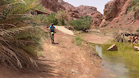
trail: Lama Base Trail
0 |
May 16, 2022 @ 7:00pm
May 16, 2022
trail: Lama Base Trail
5 |
May 16, 2022 @ 7:00pm
May 16, 2022
trail: Lama Base Trail
7 |
May 16, 2022 @ 7:00pm
May 16, 2022Videos of Aja Mountains Mountain Bike

trail: Lama Base Trail
22 |
May 16, 2022
trail: Lama Base Trail
|
May 16, 2022
Activity Feed
| username | action | type | title | date | |
|---|---|---|---|---|---|
 | abunawafjr | add | trail | Sayhan Gravel and 5 more | May 17, 2022 @ 1:36pm May 17, 2022 |
| abunawafjr | vote | trail | Shawshan Aquifer and 4 more | May 17, 2022 @ 1:19pm May 17, 2022 |
| abunawafjr | ridden | trail | Al-Raeelah Base Trail and 3 more | May 16, 2022 @ 8:21pm May 16, 2022 |
| abunawafjr | update | region | Aja Mountains | May 16, 2022 @ 7:45pm May 16, 2022 |
| abunawafjr | add | photo | in Hofuf, Saudi Arabia and 2 more | May 16, 2022 @ 7:00pm May 16, 2022 |
Activity Type Stats
| activitytype | trails | distance | descent | descent distance | total vertical | rating | global rank | state rank | photos | reports | routes | ridelogs |
|---|---|---|---|---|---|---|---|---|---|---|---|---|
| Mountain Bike | 12 | 79 miles | 3,327 ft | 41 miles | 1,158 ft | #11 | 3 | |||||
| E-Bike | 11 | 74 miles | 2,927 ft | 36 miles | 1,158 ft | #7 | ||||||
| Hike | 12 | 79 miles | 3,327 ft | 41 miles | 1,158 ft | #6 | ||||||
| Trail Running | 12 | 79 miles | 3,327 ft | 41 miles | 1,158 ft | #6 | ||||||
| Horse | 11 | 74 miles | 2,927 ft | 36 miles | 1,158 ft | #6 | ||||||
| Dirtbike/Moto | 11 | 74 miles | 2,927 ft | 36 miles | 1,158 ft | #6 | ||||||
| Observed Trials | 1 | 4 miles | 266 ft | 1 mile | 394 ft | |||||||
| ATV/ORV/OHV | 11 | 74 miles | 2,927 ft | 36 miles | 1,158 ft | #6 |
- By abunawafjr
 DA & contributors
 - Admins: apply
- #50998 - 121 views
- aja mountains activity log | embed map of Aja Mountains mountain bike trails |
Downloading of trail gps tracks in kml & gpx formats is enabled for Aja Mountains.
You must login to download files.