close
Trail Conditions
- Unknown
- Snow Groomed
- Snow Packed
- Snow Covered
- Snow Cover Inadequate
- Freeze/thaw Cycle
- Icy
- Prevalent Mud
- Wet
- Variable
- Ideal
- Dry
- Very Dry
Trail Flow (Ridden Direction)
Trailforks scans users ridelogs to determine the most popular direction each trail is ridden. A good flowing trail network will have most trails flowing in a single direction according to their intension.
The colour categories are based on what percentage of riders are riding a trail in its intended direction.
The colour categories are based on what percentage of riders are riding a trail in its intended direction.
- > 96%
- > 90%
- > 80%
- > 70%
- > 50%
- < 50%
- bi-directional trail
- no data
Trail Last Ridden
Trailforks scans ridelogs to determine the last time a trail was ridden.
- < 2 days
- < 1 week
- < 2 weeks
- < 1 month
- < 6 months
- > 6 months
Trail Ridden Direction
The intended direction a trail should be ridden.
- Downhill Only
- Downhill Primary
- Both Directions
- Uphill Primary
- Uphill Only
- One Direction
Contribute Details
Colors indicate trail is missing specified detail.
- Description
- Photos
- Description & Photos
- Videos
Trail Popularity ?
Trailforks scans ridelogs to determine which trails are ridden the most in the last 9 months.
Trails are compared with nearby trails in the same city region with a possible 25 colour shades.
Think of this as a heatmap, more rides = more kinetic energy = warmer colors.
- most popular
- popular
- less popular
- not popular
ATV/ORV/OHV Filter
Max Vehicle Width
inches
Radar Time
x
Activity Recordings
Trailforks users anonymized public ridelogs from the past 6 months.
- mountain biking recent
- mountain biking (>6 month)
- hiking (1 year)
- moto (1 year)
Activity Recordings
Trailforks users anonymized public skilogs from the past 12 months.
- Downhill Ski
- Backcountry Ski
- Nordic Ski
Jump Magnitude Heatmap
Heatmap of where riders jump on trails. Zoom in to see individual jumps, click circles to view jump details.
Trails Deemphasized
Trails are shown in grey.
Only show trails with NO bikes.
Save the current map location and zoom level as your default home location whenever this page is loaded.
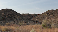
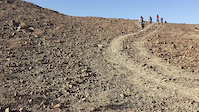
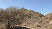
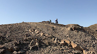
SaveThe mini hills around Al Khoud Village are home to natural and man made singletrack suitable for all abilities
Primary Trail Type: Cross-Country
AKA: Trailz in da Khoud
Land Status: Unmanaged Wilderness Area
 google parking directions
 Region Supporters & Maintainers
![]()
Joe BunnBuilder
Activities Click to view
- Mountain Bike
49 trails
- E-Bike
3 trails
- Hike
44 trails
- Trail Running
44 trails
Region Details
- 5
- 12
- 23
- 7
- 2
Region Status
Caution as of Oct 15, 2021Local Trail Association
Stats
- Avg Trail Rating
- Trails (view details)
- 50
- Trails Mountain Bike
- 49
- Trails E-Bike
- 3
- Trails Hike
- 44
- Trails Trail Running
- 44
- Trails Dirtbike/Moto
- 1
- Total Distance
- 55 miles
- Total Descent
- 3,082 ft
- Total Vertical
- 602 ft
- Highest Trailhead
- 738 ft
- Reports
- 199
- Photos
- 132
- Ridden Counter
- 2,379
Popular Al Khoud Mountain Biking Trails
Al Khoud Mountain Bike Routes
| title | rating | distance |
|---|---|---|
| Khoud you believe it? | 20 miles | |
| HVT | 3 miles | |
| Jurassic World Loop | 10 miles | |
| Al Khoud Trail Centre | 16 miles | |
| Jurassic World Route | 5 miles | |
| Tomb Raider Time Trial Kids 7-9 route | 3,081 ft | |
| It's all Khoud | 12 miles | |
| Khoud it be Magic? | 30 miles | |
| Kidz in da Khoud Race Route | 2,293 ft | |
| Trailz in da Khoud XC Race route race | 3 miles |
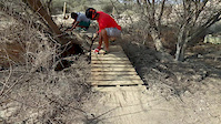
Photos of Al Khoud Mountain Bike
trail: Wonderful Winding Wadi
18 |
Dec 29, 2021 @ 2:38am
Dec 29, 2021
trail: Tomb Raider
33 |
Sep 17, 2021 @ 6:33pm
Sep 17, 2021
trail: Tomb Raider
18 |
Sep 17, 2021 @ 5:59pm
Sep 17, 2021
trail: Tomb Raider
26 |
Sep 17, 2021 @ 5:59pm
Sep 17, 2021
trail: Tomb Raider
28 |
Sep 17, 2021 @ 5:59pm
Sep 17, 2021
trail: Tomb Raider
44 |
Dec 5, 2020 @ 12:04am
Dec 5, 2020
trail: Trailz in da Khoud 1
191 |
Dec 17, 2017 @ 8:35pm
Dec 17, 2017
trail: Trailz in da Khoud 1
49 |
Oct 27, 2017 @ 10:14am
Oct 27, 2017Videos of Al Khoud Mountain Bike
trail: Hadrosaur Ridge
0:11 |
56 |
Apr 6, 2019
trail: Hadrosaur Ridge
4:02 |
212 |
Apr 22, 2018
trail: Sugar & Jam - 001
0:44 |
143 |
Mar 24, 2018
trail: The Lost World
0:22 |
612 |
Mar 23, 2018
trail: Tomb Raider
6:08 |
676 |
Dec 16, 2017
Recent Trail Reports
| status | trail | date | condition | info | user |
|---|---|---|---|---|---|
| Al Nahal Bees | Jan 5, 2022 @ 4:35am Jan 5, 2022 | Dry | hamed-alwaalmtbteam | ||
| Level Up | Oct 9, 2021 @ 10:16pm Oct 9, 2021 | Ideal | joebunn OTB | ||
| Up-down-left-right-A-B | Oct 9, 2021 @ 10:16pm Oct 9, 2021 | Ideal | joebunn OTB | ||
| Right-Left-Right-Left-Start | Oct 9, 2021 @ 10:16pm Oct 9, 2021 | Ideal | joebunn OTB | ||
| Every Day I Dream About Racing | Oct 9, 2021 @ 10:16pm Oct 9, 2021 | Ideal | joebunn OTB | ||
| Home Invader | Oct 9, 2021 @ 10:16pm Oct 9, 2021 | Ideal | joebunn OTB | ||
| HI-High-Hill | Oct 9, 2021 @ 10:16pm Oct 9, 2021 | Ideal | joebunn OTB | ||
| Wonderful Winding Wadi | Oct 9, 2021 @ 10:16pm Oct 9, 2021 | Ideal | joebunn OTB | ||
| Jurassic Park | Oct 9, 2021 @ 10:16pm Oct 9, 2021 | Ideal | joebunn OTB | ||
| Dragon's Tail | Oct 9, 2021 @ 10:16pm Oct 9, 2021 | Ideal | joebunn OTB |
Activity Feed
| username | action | type | title | date | |
|---|---|---|---|---|---|
 | bader912 | wishlist | trail | Tomb Raider Entrance | Jun 3, 2022 @ 1:17am Jun 3, 2022 |
| ChrisDaniels | ridden | trail | Tomb Raider Entrance | Apr 26, 2022 @ 12:57am Apr 26, 2022 |
| ChrisDaniels | ridden | trail | Tunnel Vision and 11 more | Apr 7, 2022 @ 4:32am Apr 7, 2022 |
| Randallfl3lqH | ridden | trail | Jurassic Park | Mar 2, 2022 @ 4:31am Mar 2, 2022 |
| Lukevclark | wishlist | trail | Tomb Raider and 1 more | Feb 22, 2022 @ 1:11am Feb 22, 2022 |
Recent Comments
| username | type | title | comment | date | |
|---|---|---|---|---|---|
| report | Excellent job appreciate the hard work :) | Nov 26, 2020 @ 12:10am Nov 26, 2020 | ||
| trail | In | Oct 30, 2020 @ 2:30am Oct 30, 2020 | ||
| trail | Very good place for practicing | Oct 21, 2020 @ 3:14am Oct 21, 2020 | ||
| trail | Was a little wet in the middle near the... | Oct 20, 2020 @ 11:45am Oct 20, 2020 | ||
| report | Great efforts | Sep 1, 2020 @ 1:53am Sep 1, 2020 |
Nearby Areas
| name | distance | ||||
|---|---|---|---|---|---|
| Jiffnain Trails | 5 | 8 | 11.3 km | ||
| Bousher | 9 | 9 | 1 | 1 | 16.1 km |
| Hamriya | 3 | 14 | 6 | 29.8 km |
Local Badges
-

Completionist0 awarded
Activity Type Stats
| activitytype | trails | distance | descent | descent distance | total vertical | rating | global rank | state rank | photos | reports | routes | ridelogs |
|---|---|---|---|---|---|---|---|---|---|---|---|---|
| Mountain Bike | 49 | 47 miles | 3,084 ft | 16 miles | 604 ft | #1,419 | #1 | 131 | 199 | 18 | 4,261 | |
| E-Bike | 3 | 9 miles | 20 ft | 2,500 ft | 436 ft | #4 | 178 | 1 | 8 | |||
| Hike | 44 | 53 miles | 2,835 ft | 15 miles | 604 ft | #1,199 | #1 | 193 | 4 | 58 | ||
| Trail Running | 44 | 53 miles | 2,835 ft | 15 miles | 604 ft | #1,208 | #1 | 193 | 4 | 49 | ||
| Dirtbike/Moto | 1 | 7 miles | 7 ft | 1,306 ft | 420 ft | 1 | 60 | 1 |
- By joebunn
 OTB & contributors
 - Admins: joebunn, whitedp, OTB
- #19436 - 4,474 views
- al khoud activity log | embed map of Al Khoud mountain bike trails | al khoud mountain biking points of interest
Downloading of trail gps tracks in kml & gpx formats is enabled for Al Khoud.
You must login to download files.