close
Trail Conditions
- Unknown
- Snow Groomed
- Snow Packed
- Snow Covered
- Snow Cover Inadequate
- Freeze/thaw Cycle
- Icy
- Prevalent Mud
- Wet
- Variable
- Ideal
- Dry
- Very Dry
Trail Flow (Ridden Direction)
Trailforks scans users ridelogs to determine the most popular direction each trail is ridden. A good flowing trail network will have most trails flowing in a single direction according to their intension.
The colour categories are based on what percentage of riders are riding a trail in its intended direction.
The colour categories are based on what percentage of riders are riding a trail in its intended direction.
- > 96%
- > 90%
- > 80%
- > 70%
- > 50%
- < 50%
- bi-directional trail
- no data
Trail Last Ridden
Trailforks scans ridelogs to determine the last time a trail was ridden.
- < 2 days
- < 1 week
- < 2 weeks
- < 1 month
- < 6 months
- > 6 months
Trail Ridden Direction
The intended direction a trail should be ridden.
- Downhill Only
- Downhill Primary
- Both Directions
- Uphill Primary
- Uphill Only
- One Direction
Contribute Details
Colors indicate trail is missing specified detail.
- Description
- Photos
- Description & Photos
- Videos
Trail Popularity ?
Trailforks scans ridelogs to determine which trails are ridden the most in the last 9 months.
Trails are compared with nearby trails in the same city region with a possible 25 colour shades.
Think of this as a heatmap, more rides = more kinetic energy = warmer colors.
- most popular
- popular
- less popular
- not popular
ATV/ORV/OHV Filter
Max Vehicle Width
inches
Radar Time
x
Activity Recordings
Trailforks users anonymized public ridelogs from the past 6 months.
- mountain biking recent
- mountain biking (>6 month)
- hiking (1 year)
- moto (1 year)
Activity Recordings
Trailforks users anonymized public skilogs from the past 12 months.
- Downhill Ski
- Backcountry Ski
- Nordic Ski
Jump Magnitude Heatmap
Heatmap of where riders jump on trails. Zoom in to see individual jumps, click circles to view jump details.
Trails Deemphasized
Trails are shown in grey.
Only show trails with NO bikes.
Save the current map location and zoom level as your default home location whenever this page is loaded.
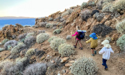
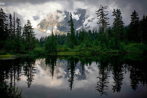
SaveWashington State has one of the most diverse climates of all of the fifty states. Within a relatively short amount of time, one can roll down trails lined with thousands of wildflowers, open fields of grass, or through pine scented forests of the central cascades. Year round riding occurs throughout the state, but perhaps there's nothing like the transition from the daily winter deluge in Western Washington to the day when the right amount of sunshine and moisture in the soil comes into equilibrium and the term "Hero dirt" or "Velcro" comes out of the mouth of every mountain biker.
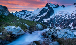
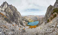
Washington is an outstanding place to bring your mountain bike with and visit as much as it is to live here. With well developed trail networks like Galbraith, Duthie Hill, Leavenworth, Black Diamond Open Space and Beacon Hill to areas being developed by the Evergreen Mountain Bike Alliance and volunteers like the Raging River Network, Squilchuck, Towns to Teanaway and beyond, Washington welcomes mountain bikers
Washington Trail Areas: https://www.trailforks.com/region/washington/ridingareas/
Washington's Favorite Trails: https://www.trailforks.com/region/washington/trails/
Fantastic camping, mountain climbing, fishing, bike packing and of course fine brewery's can be found throughout Washington. Come and explore the great Pacific Northwest!
Stats
- Avg Trail Rating
- Trails (view details)
- 9,689
- Trails Mountain Bike
- 6,618
- Trails E-Bike
- 1,950
- Trails Hike
- 8,743
- Trails Trail Running
- 8,641
- Trails Horse
- 1,684
- Trails Dirtbike/Moto
- 723
- Trails Observed Trials
- 335
- Trails ATV/ORV/OHV
- 428
- Trails Snowmobile
- 81
- Trails Snowshoe
- 517
- Trails Downhill Ski
- 355
- Trails Backcountry Ski
- 211
- Trails Nordic Ski
- 315
- Total Distance
- 16,482 miles
- Total Descent
- 3,103,501 ft
- Total Vertical
- 14,397 ft
- Highest Trailhead
- 14,397 ft
- Reports
- 66,625
- Photos
- 23,106
- Ridden Counter
- 1,103,533
 Articles
The Ethics of Thru-Hiking with Kids
Jun 13, 2022 from outsideonline.com
Each year, more families seem to earn attention by taking to long trails with small children. What are their motivations, and is it bad for the kids?

Recommended Routes: Hoh Rainforest Route - CyclingTips
May 27, 2022 from cyclingtips.com
Our Recommended Routes series continues in the moody Pacific Northwest.
The Country's Most Beautiful Mountaineering Route
May 21, 2022 from outsideonline.com
The Ptarmigan Traverse in Washington State’s North Cascades has had the word “classic” pinned to it nearly from the time it was pioneered in...
The Best Hikes in Washington
Apr 6, 2022 from backpacker.com
Backpacker presents the best hikes in Washington. From dayhikes to overnights, Backpacker's experts explore the best trails in Washington.
Popular Trail Networks
view all areas »Sub Regions
- Central (439)
- Central Cascades (478)
- Pilchuck (9)
- Snohomish County (476)
- Columbia River Gorge National Scenic Area (50)
- Colville National Forest (53)
- Kettle Crest (84)
- Coyote Bowl (0)
- East Washington (290)
- Gifford Pinchot National Forest (278)
- Highway 410 (West) (87)
- Island County (48)
- Camano Island (6)
- Whidbey Island (132)
- King County (1,243)
- Mercer Island (0)
- Kittitas County (576)
- Kachess Ridge (26)
- Teanaway (192)
- Klickitat County (9)
- Lake Wenatchee (115)
- Lopez Island (2)
- Mount Rainier National Park (2)
- Mt. Baker-Snoqualmie National Forest (40)
- Northeastern Washington (286)
- Okanogan County (182)
- Methow Valley (149)
- Okanogan-Wenatchee National Forest (58)
- Olympic Peninsula (542)
- Orcas Island (30)
- Pacific Coast South (10)
- San Juan Island (18)
- Skagit County (209)
- South Puget Sound (171)
- Pierce County (186)
- Thurston County (54)
- Southeastern Washington (33)
- Southwest (231)
- Clark County (60)
- Cowlitz County (12)
- The North Cascades - EAST (1)
- The Palouse (21)
- Tri-Cities (2)
- West Sound (303)
- Kitsap County (123)
- Whatcom County (466)
- Yakima County (33)
Popular Washington Mountain Biking Trails
| status | title | difficulty | rating |
|---|---|---|---|
| Unemployment Line Galbraith | |||
| Master Link Tiger Mountain State Forest | |||
| Atomic Dog Galbraith | |||
| Quick Link Tiger Mountain State Forest | |||
| Connector Trail Tiger Mountain State Forest | |||
| Evolution Galbraith | |||
| Honey Badger Duthie Hill Mountain Bike Park | |||
| Flow State Upper Raging River State Forest | |||
| Duthie Access Road to Clearing Duthie Hill Mountain Bike Park | |||
| Flow State Lower Raging River State Forest | |||
| Parking lot connector trail Duthie Hill Mountain Bike Park | |||
| Flow Park Walk-up Trail Duthie Hill Mountain Bike Park | |||
| Deuces Wild Duthie Hill Mountain Bike Park | |||
| Upward Mobility Raging River State Forest | |||
| Voodoo Child Duthie Hill Mountain Bike Park |
Washington Mountain Bike Routes
| title | rating | distance |
|---|---|---|
| Tarbell Loop Yacolt Burn State Forest | 23 miles | |
| Climb from Lower to Upper Lot Yacolt Burn State Forest | 4 miles | |
| Shuttle Zone Climb North Mountain | 5 miles | |
| Bike Route from Darrington to the North Mtn Skills Park North Mountain | 3 miles | |
| Bike Route from Darrington to the Lookout North Mountain | 11 miles | |
| Effff'n A, Teanaway Teanaway Community Forest | 20 miles | |
| Shuttle Road Driving Route North Mountain | 8 miles | |
| Up, then Flow Raging River State Forest | 5 miles | |
| OTG to Ebad and out Tiger Mountain State Forest | 10 miles | |
| 2022 CDC: Tiger Mt Enduro - Lite Tiger Mountain State Forest | 7 miles |
Photos of Washington Mountain Bike
trail: Oly
174 |
Sep 29, 2018 @ 5:02pm
Sep 29, 2018
trail: Das Auto Bahn
832 |
Sep 8, 2018 @ 7:35pm
Sep 8, 2018
trail: NOTG
1,109 |
Sep 4, 2018 @ 2:05am
Sep 4, 2018
trail: El Pollo Elastico
237 |
Jul 12, 2017 @ 12:04am
Jul 12, 2017
trail: Master Link
752 |
Apr 13, 2017 @ 10:04pm
Apr 13, 2017
trail: Master Link
984 |
Apr 13, 2017 @ 10:04pm
Apr 13, 2017
trail: Lair of the Bear
653 |
Mar 31, 2017 @ 9:34am
Mar 31, 2017
trail: Irish Death
1,973 | | 3 comments
Mar 31, 2017 @ 9:33am
Mar 31, 2017Videos of Washington Mountain Bike
trail: Over Easy
14 |
Jul 1, 2022
trail: Coffee Tables
5 |
Jul 1, 2022

trail: Melody
7 |
Jul 1, 2022

trail: Gravy Train
48 |
Jun 25, 2022
trail: Cedar Dust Expert Jump Line
65 |
Jun 24, 2022
trail: Cool Runnings
92 |
Jun 21, 2022

trail: Deep Water Horizon
54 |
Jun 20, 2022
trail: Feel The Pain
82 |
Jun 7, 2022
Activity Feed
| username | action | type | title | date | |
|---|---|---|---|---|---|
 | mattmacdonald5784 | wishlist | route | Specialized Galbraith Enduro Presented by Soil Searching | Jul 6, 2022 @ 12:26am 2 hours |
 | p13rr3 | wishlist | route | Specialized Galbraith Enduro Presented by Soil Searching - SPORT* | Jul 6, 2022 @ 12:00am 2 hours |
| bigjimdaniel | wishlist | route | Specialized Galbraith Enduro Presented by Soil Searching | Jul 5, 2022 @ 11:40pm 2 hours |
 | clay-glennon | wishlist | route | Specialized Galbraith Enduro Presented by Soil Searching - SPORT* | Jul 5, 2022 @ 11:36pm 2 hours |
| emptyvoxel | wishlist | route | Specialized Galbraith Enduro Presented by Soil Searching - SPORT* | Jul 5, 2022 @ 11:24pm 3 hours |
Recent Comments
| username | type | title | comment | date | |
|---|---|---|---|---|---|
| trail | If you’re comfortable riding skyline you... | Jul 5, 2022 @ 4:34pm 9 hours | ||
| trail | Great trail. Very fast and float. No mandatory... | Jul 5, 2022 @ 1:55pm 12 hours | ||
| trail | Pretty straightforward road climb to get to... | Jul 5, 2022 @ 7:52am 18 hours | ||
| trail | Perfect shortcut, smooth grade, and an awesome... | Jul 5, 2022 @ 7:49am 18 hours | ||
| trail | The up part of this is very up. You will hike... | Jul 5, 2022 @ 7:46am 18 hours |
Local Badges
-

Evergreen Dirty Dozen 20213 awarded -

Evergreen Dirty Dozen 20201 awarded -

Ride Local: Demo Lap819 awarded -

Tiger Tamed5 awarded -

Sea 2 Sky22 awarded -

Sixth Sense Evergreen SW Flash Membership16 awarded
National Scenic Trails & Official Routes
-
Pacific Northwest Trail
- Mountain Bike
- Hike
- Trail Running
- Horse
Bike & Skill Parks
| name | type | city | rating |
|---|---|---|---|
| Mt. Spokane Cross-Country Ski Park | bike park | Spokane | |
| Snoqualmie Pass Bike Park | bike park | ||
| 360 Pump Track | skill park | ||
| Beacon Hill Bike park | skill park | Spokane | |
| Beginner Pumptrack | skill park | Issaquah |
Upcoming Local Events
Activity Type Stats
| activitytype | trails | distance | descent | descent distance | total vertical | rating | global rank | state rank | photos | reports | routes | ridelogs |
|---|---|---|---|---|---|---|---|---|---|---|---|---|
| Mountain Bike | 6,618 | 10,248 miles | 1,760,295 ft | 4,447 miles | 8,238 ft | #5 | 22,595 | 66,293 | 702 | 776,344 | ||
| E-Bike | 1,950 | 4,484 miles | 777,221 ft | 1,984 mile | 8,071 ft | #11 | 2 | 49,305 | 38 | 12,078 | ||
| Hike | 8,742 | 15,874 miles | 2,808,514 ft | 6,622 miles | 14,396 ft | #8 | 378 | 63,006 | 558 | 44,817 | ||
| Trail Running | 8,641 | 15,663 miles | 2,775,479 ft | 6,558 miles | 12,290 ft | #8 | 43 | 63,007 | 203 | 25,702 | ||
| Horse | 1,684 | 4,552 miles | 716,955 ft | 1,874 mile | 8,727 ft | #9 | 1 | 21,792 | 22 | 225 | ||
| Dirtbike/Moto | 723 | 2,381 miles | 422,159 ft | 1,080 mile | 7,454 ft | #8 | 45 | 20,111 | 13 | 626 | ||
| Observed Trials | 335 | 1,137 mile | 174,544 ft | 536 miles | 7,034 ft | #6 | 12 | 972 | 3 | 59 | ||
| ATV/ORV/OHV | 428 | 1,150 mile | 142,595 ft | 491 miles | 6,775 ft | #11 | 16 | 19,161 | 4 | 233 | ||
| Snowmobile | 81 | 203 miles | 27,605 ft | 64 miles | 6,736 ft | #12 | 8 | 1,171 | 2 | 159 | ||
| Snowshoe | 517 | 1,072 mile | 170,217 ft | 411 miles | 8,488 ft | #23 | 1,572 | 5 | 1,056 | |||
| Downhill Ski | 355 | 172 miles | 165,978 ft | 146 miles | 6,785 ft | #12 | 4 | 229 | 12,043 | |||
| Backcountry Ski | 211 | 527 miles | 105,781 ft | 194 miles | 14,199 ft | #16 | 1 | 664 | 1 | 5,838 | ||
| Nordic Ski | 315 | 450 miles | 53,261 ft | 175 miles | 6,706 ft | #21 | 866 | 1 | 6,301 |
- By canadaka
 Trailforks & contributors
 - Admins: Map Team, chuktA, msmcfate, WillieJacobsz, PlumbBobM, ReckitRolley, EMBA, NMA, codyolsen, boxxerace
- #3051 - 153,744 views
- washington activity log | embed map of Washington mountain bike trails | washington mountain biking points of interest polygons
-
- subscribe
- 3d map
Downloading of trail gps tracks in kml & gpx formats is enabled for Washington.
You must login to download files.