close
Trail Conditions
- Unknown
- Snow Groomed
- Snow Packed
- Snow Covered
- Snow Cover Inadequate
- Freeze/thaw Cycle
- Icy
- Prevalent Mud
- Wet
- Variable
- Ideal
- Dry
- Very Dry
Trail Flow (Ridden Direction)
Trailforks scans users ridelogs to determine the most popular direction each trail is ridden. A good flowing trail network will have most trails flowing in a single direction according to their intension.
The colour categories are based on what percentage of riders are riding a trail in its intended direction.
The colour categories are based on what percentage of riders are riding a trail in its intended direction.
- > 96%
- > 90%
- > 80%
- > 70%
- > 50%
- < 50%
- bi-directional trail
- no data
Trail Last Ridden
Trailforks scans ridelogs to determine the last time a trail was ridden.
- < 2 days
- < 1 week
- < 2 weeks
- < 1 month
- < 6 months
- > 6 months
Trail Ridden Direction
The intended direction a trail should be ridden.
- Downhill Only
- Downhill Primary
- Both Directions
- Uphill Primary
- Uphill Only
- One Direction
Contribute Details
Colors indicate trail is missing specified detail.
- Description
- Photos
- Description & Photos
- Videos
Trail Popularity ?
Trailforks scans ridelogs to determine which trails are ridden the most in the last 9 months.
Trails are compared with nearby trails in the same city region with a possible 25 colour shades.
Think of this as a heatmap, more rides = more kinetic energy = warmer colors.
- most popular
- popular
- less popular
- not popular
ATV/ORV/OHV Filter
Max Vehicle Width
inches
Radar Time
x
Activity Recordings
Trailforks users anonymized public ridelogs from the past 6 months.
- mountain biking recent
- mountain biking (>6 month)
- hiking (1 year)
- moto (1 year)
Activity Recordings
Trailforks users anonymized public skilogs from the past 12 months.
- Downhill Ski
- Backcountry Ski
- Nordic Ski
Jump Magnitude Heatmap
Heatmap of where riders jump on trails. Zoom in to see individual jumps, click circles to view jump details.
Trails Deemphasized
Trails are shown in grey.
Only show trails with NO bikes.
Save the current map location and zoom level as your default home location whenever this page is loaded.
Save
No description for Rockville Hills Regional Park has been added yet!
Login or register to submit one.
 google parking directions
Primary Trail Type: Cross-Country
AKA: Rockville
Land Status: Community Forest
google parking directions Activities Click to view
- Mountain Bike
50 trails
- E-Bike
0 trails
- Hike
50 trails
- Trail Running
50 trails
Region Details
- 10
- 7
- 13
- 17
- 2
- 1
Region Status
Open as of Jun 29, 2022Stats
- Avg Trail Rating
- Trails (view details)
- 50
- Trails Mountain Bike
- 50
- Trails Hike
- 50
- Trails Trail Running
- 50
- Total Distance
- 18 miles
- Total Descent
- 3,773 ft
- Total Vertical
- 449 ft
- Highest Trailhead
- 564 ft
- Reports
- 786
- Photos
- 108
- Ridden Counter
- 22,136
Popular Rockville Hills Regional Park Trails
Mountain Bike Routes
| title | rating | distance |
|---|---|---|
| Chill Rockville Loop | 4 miles | |
| Rockville 10-miler | 10 miles | |
| Rockvile Black Diamond Tour | 7 miles | |
| Rockvile Black Diamond Tour | 7 miles | |
| Rockville 5 Mile Loop | 5 miles | |
| First XC | 3 miles | |
| Rockhopper Enduro race | 10 miles |
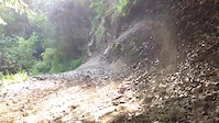
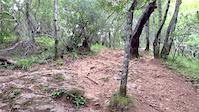
Photos of Rockville Hills Regional Park Mountain Bike
trail: The Outback
50 |
Feb 22, 2021 @ 3:35pm
Feb 22, 2021
trail: Rockville Trail
193 |
Oct 6, 2020 @ 9:11pm
Oct 6, 2020
trail: Quarry
376 |
Apr 20, 2019 @ 9:46pm
Apr 20, 2019
trail: Quarry
462 |
Apr 20, 2019 @ 9:41pm
Apr 20, 2019
trail: Rockville Trail
125 |
Jun 16, 2018 @ 6:25pm
Jun 16, 2018
trail: Rockville Trail
735 |
Oct 30, 2016 @ 12:10pm
Oct 30, 2016Videos of Rockville Hills Regional Park Mountain Bike
trail: Rockville Trail
61 |
Jan 28, 2022

trail: Manzanita Trail
92 |
Nov 15, 2020
trail: Rockville Trail
0:22 |
462 |
May 6, 2019

trail: Fire road
7:11 |
33 |
Aug 22, 2018
trail: Cascade Trail
0:31 |
531 |
Sep 1, 2014
trail: Rock Garden
1:02 |
256 |
Jun 13, 2014
trail: Rock Garden
0:08 |
394 |
Apr 8, 2014
trail: Rock Garden
0:13 |
570 |
Mar 2, 2013
Recent Trail Reports
| status | trail | date | condition | info | user |
|---|---|---|---|---|---|
| Devil's Backbone | Jun 18, 2022 @ 12:09pm Jun 18, 2022 | Dry | Z5Qg8I | ||
| Lake Front | Jun 18, 2022 @ 12:09pm Jun 18, 2022 | Dry | Z5Qg8I | ||
| Upper to Lower Tilley Technical Downhill | Jun 18, 2022 @ 12:07pm Jun 18, 2022 | Dry | Z5Qg8I | ||
| Upper Tilley Trail | Jun 18, 2022 @ 12:07pm Jun 18, 2022 | Dry | Z5Qg8I | ||
| Rockville Trail | Jun 18, 2022 @ 12:06pm Jun 18, 2022 | Dry | Z5Qg8I | ||
| Wild Turkey Run | Jun 18, 2022 @ 12:05pm Jun 18, 2022 | Dry | Z5Qg8I | ||
| Unknown | May 6, 2022 @ 10:37am May 6, 2022 | Ideal | JBlaze24 | ||
| Connector | May 6, 2022 @ 10:37am May 6, 2022 | Ideal | JBlaze24 | ||
| Connector | May 6, 2022 @ 10:37am May 6, 2022 | Ideal | JBlaze24 | ||
| Cave Trail | May 6, 2022 @ 10:37am May 6, 2022 | Ideal | JBlaze24 |
Activity Feed
| username | action | type | title | date | |
|---|---|---|---|---|---|
 | Marshee | vote | trail | Tower Trail | Jul 5, 2022 @ 12:03pm 15 hours |
| Marshee | comment | trail | Cave Trail and 2 more | Jul 5, 2022 @ 11:59am 15 hours |
 | penguino | wishlist | route | Rockvile Black Diamond Tour | Jul 1, 2022 @ 7:10am Jul 1, 2022 |
 | huntsykes | ridden | trail | Rockville Trail and 23 more | Jun 26, 2022 @ 10:54pm Jun 26, 2022 |
| KillerDuck | ridden | trail | Unknown and 1 more | Jun 18, 2022 @ 3:54pm Jun 18, 2022 |
Recent Comments
| username | type | title | comment | date | |
|---|---|---|---|---|---|
| trail | This trail starts at a sort of plateau where... | Jul 5, 2022 @ 12:03pm 15 hours | ||
| trail | There is nothing that technical on this trail... | Jul 5, 2022 @ 12:01pm 15 hours | ||
| trail | Most of the trail is only moderately technical... | Jul 5, 2022 @ 11:59am 15 hours | ||
| trail | Easily the hardest trail at the park for sure,... | Jun 18, 2022 @ 9:16am Jun 18, 2022 | ||
| trail | Loose and steep. There is really no reason... | Apr 27, 2022 @ 10:29am Apr 27, 2022 |
Nearby Areas
| name | distance | ||||
|---|---|---|---|---|---|
| Lynch Canyon Open Space | 4.8 km | ||||
| Skyline Wilderness Park | 3 | 6 | 5 | 5.9 km | |
| Hiddenbrooke | 2 | 6.5 km | |||
| Newell Open Space | 6.6 km | ||||
| Lagoon Valley Park | 4 | 4 | 5 | 9.2 km |
Local Badges
-
Rockville: 20 Miles in One Ride194 awarded -

Rockville's Toughest Tech in One Ride0 awarded -

Rockville: Every Trail in One Ride0 awarded -

Rockville: Ride Every Trail3 awarded
Activity Type Stats
| activitytype | trails | distance | descent | descent distance | total vertical | rating | global rank | state rank | photos | reports | routes | ridelogs |
|---|---|---|---|---|---|---|---|---|---|---|---|---|
| Mountain Bike | 50 | 18 miles | 3,773 ft | 9 miles | 449 ft | #220 | #95 | 100 | 786 | 7 | 7,414 | |
| Hike | 50 | 18 miles | 3,773 ft | 9 miles | 449 ft | #139 | #71 | 1 | 786 | 1 | 91 | |
| Trail Running | 50 | 18 miles | 3,773 ft | 9 miles | 449 ft | #140 | #70 | 786 | 1 | 47 |
- By TheBikeNerd
 NWTA & contributors
 - Admins: BTCEB, bkxc
- #5774 - 17,108 views
- rockville hills regional park activity log | embed map of Rockville Hills Regional Park mountain bike trails | rockville hills regional park mountain biking points of interest
Downloading of trail gps tracks in kml & gpx formats is enabled for Rockville Hills Regional Park.
You must login to download files.